• Welcome to TalkWeather!
    We see you lurking around TalkWeather! Take the extra step and join us today to view attachments, see less ads and maybe even join the discussion.
    CLICK TO JOIN TALKWEATHER
Logo 468x120

Severe Weather 2021

Kory

Member
Messages
4,928
Reaction score
2,119
Location
Tuscaloosa, Alabama
While the Euro itself is a higher end look, a big -NAO plunge in a largely -NAO regime for this month makes me skeptical that the Euro solution has much legs. This one has a long way to go. GFS again isn’t nearly as bullish...matter of fact the latest 18z run is quite tame comparatively.
 

Kory

Member
Messages
4,928
Reaction score
2,119
Location
Tuscaloosa, Alabama
This type of pattern with lots of cut offs tend to reinforce the high latitude blocking we’ve seen definitely hamper this month’s severe wx production.

Add in the recurving typhoon many were speculating were going to get absorbed/phased with a mid latitude system and shake up the pattern...that doesn’t appear to be the case in latest guidance.
 

andyhb

Member
Messages
1,033
Reaction score
2,689
Location
Norman, OK
This type of pattern with lots of cut offs tend to reinforce the high latitude blocking we’ve seen definitely hamper this month’s severe wx production.

Add in the recurving typhoon many were speculating were going to get absorbed/phased with a mid latitude system and shake up the pattern...that doesn’t appear to be the case in latest guidance.
Huh? The TC gets absorbed into the flow on all guidance in the D4-5 period and is partly responsible for the development of the jet extension in the Pacific going into early May.

Add in active MJO progression and it's no surprise there's some shift in mid-range ensemble guidance towards a more favorable pattern relative to the one that has been in place for mid April.
 

Keldeo

Member
Messages
62
Reaction score
42
Location
North Little Rock
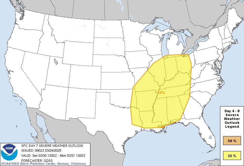
day7prob.gif


Medium-range guidance
remains in fairly good agreement that another large-scale upper
trough will advance eastward from the western CONUS to the Plains in
the Day 6/Monday to Day 7/Tuesday time frame. The past several runs
of the deterministic ECMWF show a very favorable setup for organized
severe thunderstorms capable of producing all severe hazards across
parts of central TX into OK and southern KS, with moderate to strong
instability forecast to overlap rich low-level moisture in the
presence of strong deep-layer shear. There has been a consistent
enough signal in guidance suggesting a substantial severe threat may
develop across these areas next Tuesday to introduce 15% severe
probabilities. Greater probabilities may be needed if current model
trends continue.


Pretty strong wording already from the SPC. Doesn't help that this is happening on a very infamous anniversary.......
 

MattW

Member
Messages
307
Reaction score
206
Location
Decatur, GA
HAM Callsign
KG4GUF
Special Affiliations
  1. SKYWARN® Volunteer
Next weeks looks intense, but let's not forget about this weekend. This sounding is from the NAM (end of its range I know) about 20 miles WSW of Macon, GA at 14:00 EDT.
 

Attachments

  • nam_2021042106_084_32.78--83.96.png
    nam_2021042106_084_32.78--83.96.png
    241.9 KB · Views: 0

Tennie

Member
Messages
935
Reaction score
761
Location
Tennessee
Notice the possible Pds tornado tag at the bottom right

And also note that many of the SARS analogs were cool-season events, whereas this system seems to be more of a warm-season event. Make of that what you will...
 

Brice Wood

Member
Messages
295
Reaction score
181
Location
Virginia
It's far from unheard of, but it's still over quite a large area and it's farther east into parts of Georgia than is usually the case with a lot of systems.
Yea it just breaks my heart to see Alabama, Mississippi, and Georgia dealing with another potential outbreak
 

Clancy

Member
Messages
2,297
Reaction score
3,966
Location
Macland, Georgia
BMX AFD mentions severe potential Saturday but harbors skepticism about the degree of stabilization in the afternoon, as there's supposed to be some of that classic morning precip ahead of the main event.Screenshot_20210421-124026~2.jpg
 

Tennie

Member
Messages
935
Reaction score
761
Location
Tennessee
I just realized:

We've been talking about how there looks to be a severe weather setup forking for the Great Plains on the 27th, and that that date will be a certain 10th anniversary, but it should also be pointed out that that date will also be one day after the 30th anniversary of the tornado outbreak that featured the Andover and Red Rock tornadoes (among others). So keep that in mind.
 

Brice Wood

Member
Messages
295
Reaction score
181
Location
Virginia
I just realized:

We've been talking about how there looks to be a severe weather setup forking for the Great Plains on the 27th, and that that date will be a certain 10th anniversary, but it should also be pointed out that that date will also be one day after the 30th anniversary of the tornado outbreak that featured the Andover and Red Rock tornadoes (among others). So keep that in mind.
Oh my goodness, that’s eerily true
 
Back
Top