National Weather Service Jackson MS
327 PM CDT Tue Apr 6 2021
Edited for emphasis:
In general terms, the latest global guidance continues to come into
better agreement on storm potential as we move into the end of the
week. Yesterday there was more variability and solutions supporting
a couple rounds from later Thu into late
Sat. Now, solutions are
converging more on one main event in the Fri afternoon and night
periods with potential for some pre activity later Thu night into
early Fri. This increased agreement is mainly driven by the energy
moving into the PacNW on Thu then becoming more phased as it drops
into the
mean trough axis on Fri over the central
CONUS. As all of
this occurs, our region will see a return of low level
moisture
later on Thu and into Fri as more response takes shape with the
development of a
sfc low over the Red River Valley.
All this occurs
under cold temps aloft which will promote steep to very steep lapse
rates (VT of 29-31c).
Additionally, the upper jet structure will be
very supportive with strong left exit dynamics in play and quite a
bit of potential vorticity in the upper levels. Additionally,
various cape outputs show energy in the 2500-4000 j/kg range. With
these elements, vigorous updrafts are likely. In terms of kinematics,
low and midlevels are not strong like the upper jet. However, latest
trends have show more of a develop/deepening sfc low which will
likely contribute to increased low level shear. Much of this will
hinge on
sfc front position and magnitude of deep ascent to aid in
the reality of where a
sfc low will track. Finally, the
qpf response
from the global models has quite the intense signal resulting in
large disruptions to the model fields. This is a feedback response
and often wreaks havoc on
downstream forecasts. However, it also is a
signal on on the volatility in the potential environment which is
supported by some of the high end elements.
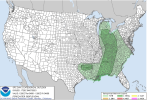
To summarize,
the system for late week looks to be quite potent and
the underlying environment will be primed and supportive of
significant severe storms. Specific timing is too tough to cover,
but a broad window of multiple storms is becoming
likely any time
from late Thu night, Friday and into the early morning hours of
Sat.
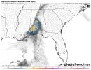
Due to the potential for some high end severe storms, we wanted to
highlight this threat in our HWO and issue a graphic. While we are
starting with a "Slight" risk,
anticipate this to increase along
with locations and timing to adjust as more information is know and
confidence in the specifics increases. Additionally, with multiple
storms, heavy
rainfall and
flash flooding may also become a threat.
This will be something we can focus more on as we get closer and
have a better idea of the complex storm evolution and potential for
where repetitive storms may be more
likely.