
Curious if it’s because MIC in Louisville John Gordon retired recently. Maybe his heir apparent is more conservative.Amazing how two neighboring offices can differ so much.
Navigation
Install the app
How to install the app on iOS
Follow along with the video below to see how to install our site as a web app on your home screen.
Note: This feature may not be available in some browsers.
More options
-
Welcome to TalkWeather! We see you lurking around TalkWeather! Take the extra step and join us today to view attachments, see less ads and maybe even join the discussion. CLICK TO JOIN TALKWEATHER
You are using an out of date browser. It may not display this or other websites correctly.
You should upgrade or use an alternative browser.
You should upgrade or use an alternative browser.
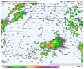
Severe WX Severe threat 3/30-3/31
- Thread starter Bulkshear
- Start date
US_Highway15
Member

Sounding pulled from NW Mississippi near the AR/MS border. Not the hodograph you wanna see at all, especially with it being late into the night.
Tomcats Forever!
Member
It does seem that way. AFDs the last time we had Tors in their CWA didn't mention twisters at all.Curious if it’s because MIC in Louisville John Gordon retired recently. Maybe his heir apparent is more conservative.
I am real curious to see the UH swaths once the CAMs come into range.
US_Highway15
Member

First look at the composite data from NAMNST for this event. I'm pretty concerned with what I'm seeing, particuarly because for the longest time it's felt like it's undersold so many past severe weather events (including 3/14). The fact that it's verifying it to this extent concerns me. I don't know, maybe I'm overreacting. Just my thoughts.
John was the man. Hard to replace that many years of experience.It does seem that way. AFDs the last time we had Tors in their CWA didn't mention twisters at all.
I am real curious to see the UH swaths once the CAMs come into range.
cniemczura
Member
I remember the F4s in Dayton being a slight day with a similar curve. A lot of people didn’t realize there was chance for severe weather that day but you could feel it.ILN doesn't sound overly concerned for the cincinnati area either. however, the later in the night sunday that storms arrive, the less likely it is that they'll have anything to work with.I remember the F4s in Dayton being a slight day with a similar curve. very few people were even aware there was the chance for severe weather that day but you could feel it.
Last edited:
wx_guy
Member
- Messages
- 1,237
- Reaction score
- 4,443
- Location
- United States
- HAM Callsign
- KO4ZGH
- Special Affiliations
- SKYWARN® Volunteer
- ARRL Member
0z HRRR incoming in what, about 60-90 minutes? *waits anxiously* Meanwhile, my WRF-ARW model is taking its dear sweet time (it has like 6 million grid points to calculate, so give my computer a break lol), so I don't think it'll be done til midnight or 1 AM. I'll try to stay up to share the results when it comes out, just FYI.
Cyclonic Paracosm
Member
I have heard that euro p much has an outbreak l, on mobile till tmr so can't view this my self
Your computer watching you prepare another run.0z HRRR incoming in what, about 60-90 minutes? *waits anxiously* Meanwhile, my WRF-ARW model is taking its dear sweet time (it has like 6 million grid points to calculate, so give my computer a break lol), so I don't think it'll be done til midnight or 1 AM. I'll try to stay up to share the results when it comes out, just FYI.

Tomcats Forever!
Member
It's probably a fairly effective space heater right now, too.Your computer watching you prepare another run.
View attachment 37582
jiharris0220
Member
Are the rumors true that you run your model just to cook briskets on your computer?0z HRRR incoming in what, about 60-90 minutes? *waits anxiously* Meanwhile, my WRF-ARW model is taking its dear sweet time (it has like 6 million grid points to calculate, so give my computer a break lol), so I don't think it'll be done til midnight or 1 AM. I'll try to stay up to share the results when it comes out, just FYI.
(Just confirming something here guys)
LoopingHodos
Member
Are the rumors true that you run your model just to cook briskets on your computer?
(Just confirming something here guys)
Runs too hot for brisket lol
KevinH
Member
Lord knows the line doesn't need to get any kinkier.

KevinH
Member
Starting to think his kind of set up should be expected for this areaView attachment 37573
Sounding pulled from NW Mississippi near the AR/MS border. Not the hodograph you wanna see at all, especially with it being late into the night.

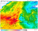
Some very impressive values off the 18Z GEFS for Sunday evening. Additionally, some very impressive SRH off the 18Z NAM for Alabama and Georgia on Monday. With instability being all but certain, the amount of kinematics that may be in place strike me as particularly concerning.


Agreed. With kinematics falling in, Biggest question may move to storm mode now. Regardless, that instability is stunningSome very impressive values off the 18Z GEFS for Sunday evening. Additionally, some very impressive SRH off the 18Z NAM for Alabama and Georgia on Monday. With instability being all but certain, the amount of kinematics that may be in place strike me as particularly concerning.
UpperLevelLOL
Member
Southern MO in the crosshairs again https://bsky.app/profile/mcbeewx.com/post/3lliaqmpyb225
- Thread starter
- #439
Bulkshear
Member
Mid 60’s to 70 dew points, sufficient shear, what could go wrong? Seriously though do you think the cap will hold or is this looking more ominous00z HRRR valid at 7pm Sunday. If that cap breaks earlier, we're gonna have trouble.
Hard to tell at this time how early it breaks. However, I believe that by that timeframe, it should be starting to give way or have already broken. I mean by 7pm, you would have already had a days worth of heating adding more fuel to an already volatile environmentMid 60’s to 70 dew points, sufficient shear, what could go wrong? Seriously though do you think the cap will hold or is this looking more ominous