• Welcome to TalkWeather!
    We see you lurking around TalkWeather! Take the extra step and join us today to view attachments, see less ads and maybe even join the discussion.
    CLICK TO JOIN TALKWEATHER

Severe WX Severe Threat 25 March 2021

One question for me, and maybe it is because of last week's event, I am wondering ifnthe most will back build a bit longer over north Alabama. Upper ridging is weak and that llj really pumping in the low level moisture
 
One question for me, and maybe it is because of last week's event, I am wondering ifnthe most will back build a bit longer over north Alabama. Upper ridging is weak and that llj really pumping in the low level moisture
If it's there at all. A lot of the higher resolution models that are starting to get within range are beginning to say "naw bruh"...

A lot of guidance, including the GFS, is focusing the morning and midday mess to the north of the AL state line.
 
Last edited:
Good lord, we're only in March! It's easy to assume a moderate risk will be issued by the SPC by tomorrow morning, but I wonder if the storm mode would prevent them from pushing an even higher risk. Then again, this system is being provided with much higher wind fields than the last one.
 
This Ukie sounding at 12z from Southwest Mississippi looks more like something from Oklahoma.

ukmet_2021032312_048_31.98--90.31.png


This is a box sounding for most of Mississippi and Alabama except the northern parts of both states.

ukmet_2021032312_048_area_31.0-34.06.-90.88--85.72.png


That's an impressive cap!
 
SREF gives a 70% chance that the STP exceeds 5 in east MS and west AL. The mean location of STP of 5+ on the SREF stretches from south MS/AL up into the Ohio Valley.
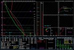
I can't recall seeing a region that large this far out on that, ever.
 
If it's there at all. A lot of the higher resolution models that are starting to get within range are beginning to say "naw bruh"...

A lot of guidance, including the GFS, is focusing the morning and midday mess to the north of the AL state line.
Thinking west tennessee going get another slop fest ? See models still differ some. May have to drive further south to catch best cells .
 
Seeing some rumblings from WXtwitter (not from the weenies, but people that I see as more respected) that this could be another high risk. Pretty crazy we could potentially get 2 high risks in just over a week.
 
BMX hinting at a significant event (last sentence) with their latest afd:


Weakening cold front is still inbound with widespread showers and
a few embedded thunderstorms. Despite its weakening state, looks
like much of the area will see some measurable rainfall. This will
be the case especially south of I20. The front will slow and
stall overnight near the coastline before beginning the track
north as a warm front tomorrow evening. Regardless of a cold,
stationary, and/or warm front, rain chances will continue through
the entire short term period. The retreat northward will mark the
beginning of what may become a robust warm sector ahead of the
stronger system expected on Thursday.
 
Seeing some rumblings from WXtwitter (not from the weenies, but people that I see as more respected) that this could be another high risk. Pretty crazy we could potentially get 2 high risks in just over a week.

It has been a while, but that used to be a semi-regular occurrence. There were four high-risk days in the period May 4-10, 2003, four in the period May 22-30, 2004, and several in a similar timespan in May of 2008.
 
HRRR coming in looking flat out ugly for Thursday afternoon. Capped warm sector, no widespread convection, 60-65kt LLJ by late morning/midday, and instability that looks notably higher than last week.
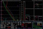
Yes, although it only goes 48 hrs, you can get a very good idea as to what kind of afternoon is in store.
 
Back
Top