
NEVERMIND....Surprised the soundings are not showing more upside down "v"'s near the surface...typically goes along with the cap.
Navigation
Install the app
How to install the app on iOS
Follow along with the video below to see how to install our site as a web app on your home screen.
Note: This feature may not be available in some browsers.
More options
-
Welcome to TalkWeather! We see you lurking around TalkWeather! Take the extra step and join us today to view attachments, see less ads and maybe even join the discussion. CLICK TO JOIN TALKWEATHER
You are using an out of date browser. It may not display this or other websites correctly.
You should upgrade or use an alternative browser.
You should upgrade or use an alternative browser.
Severe WX Severe Threat 25 March 2021
- Thread starter MattPetrulli
- Start date
-
- Tags
- severe wx
David in SW Blount
Member
I'm worried that there will be a lot of public complacency with this event after last week didn't deliver as much as people in many areas expected.
HazardousWx
Member
- Messages
- 99
- Reaction score
- 118
- Location
- Huntsville, AL
- HAM Callsign
- W4SSW
- Special Affiliations
- SKYWARN® Volunteer
Yes, because that one had a LOT of people's attention.I'm worried that there will be a lot of public complacency with this event after last week didn't deliver as much as people in many areas expected.
BraxBanksOKWX
Member
So, the 18z NAM 3k was downright nasty.


And to put the NAM/3km NAM into perspective, compared the all the other models, it is slightly less organized with the trough and low pressure. Despite what the NAM package shows (a higher-end threat), it is on the less bullish side of the possible solutions.
Correct, quite the discrepancy between nam and euro for example.And to put the NAM/3km NAM into perspective, compared the all the other models, it is slightly less organized with the trough and low pressure. Despite what the NAM package shows (a higher-end threat), it is on the less bullish side of the possible solutions.
HRRR is kinematically in the Euro/etc camp. Even the latest GFS now has a 990mb low over south IL Thursday evening that deepens into the 980s as it moves into IN. I am getting the idea more and more that this is one of those cases where the NAM is doing its classic thing of stringing out shortwave energy. The fact that it still promotes what it does is pretty eye opening. Still, I'm waiting to see the 00z models tonight before we change our L-bar and graphics backgrounds to red at the station.Correct, quite the discrepancy between nam and euro for example.

CheeselandSkies
Member
Someone said on another forum that this will be another positively tilted, closed low scenario (like last Wednesday, and thus prone to many of the same potential limiting factors/failure modes). However, looking at the 500mb chart from today's 12Z GFS, I see a big open trough with a slightly negatively tilted shortwave rolling through it (look at the 549 to 558 dam lines from NC KS to NE TX). Either I'm missing something or they are.
Attachments
You are... You're missing having your head up your donkey like where they have theirs firmly placed.Someone said on another forum that this will be another positively tilted, closed low scenario (like last Wednesday, and thus prone to many of the same potential limiting factors/failure modes). However, looking at the 500mb chart from today's 12Z GFS, I see a big open trough with a slightly negatively tilted shortwave rolling through it (look at the 549 to 558 dam lines from NC KS to NE TX). Either I'm missing something or they are.
Bama Ravens
Member
They’ve added this for Wednesday night through Thursday:BMX hinting at a significant event (last sentence) with their latest afd:
.LONG TERM...
/Updated at 0250 PM CDT Tue Mar 23 2021/
Wednesday night and Thursday.
Models are in good agreement with showers and thunderstorms
increasing from south to north Wednesday night as an upper warm
front lifts northward. Localized heavy rainfall possible across
areas north of I-20 Wednesday night. Expect most of the rain
associated with the warm front will be north of central Alabama by
sunrise Thursday. A relative lull in showers and thunderstorms
Thursday morning will allow for surface temperatures to warm and
instability to increase. With surface dewpoints in the middle to
upper 60s, surface based CAPE will likely rise to 1500-2000 J/kg
Thursday afternoon, especially across the western counties. High
0-6km bulk shear and strong low level veering will be favorable
for tornadoes. Highest threat area will reside along and west of
the I-20/59 corridor. Models weaken forcing and low level shear
quickly Thursday evening and expect severe threat to be greatly
diminished by 10 pm. For this reason, will lower severe threat for
areas east of I-65.
58/rose
CheeselandSkies
Member
You are... You're missing having your head up your donkey like where they have theirs firmly placed.
Thanks, Fred but what about the meteorology behind it? Am I accurate in discerning the shortwave axis there?
It's a low amplitude, negative tilt, fully open shortwave trough. I don't see how anybody could possibly say any differently. Even the NAM solution that's a touch more strung out than the others is an open shortwave, not a closed upper low.Thanks, Fred but what about the meteorology behind it? Am I accurate in discerning the shortwave axis there?
Marshal79344
Member
I cannot be the only person who is noticing how the models are uptrending on the intensity of the surface low, which was literally nonexistent on some of those CAM's yesterday. This is going to be another major issue due to a more organized surface low favoring more OWS development.
CheeselandSkies
Member
18Z GFS holds serve with the same general 500mb look as 12Z. Additionally, there appears to be a splitting jet at 300mb. If I understand it correctly, this serves to enhance upper-level divergence/vertical motion?
Attachments
Keldeo
Member
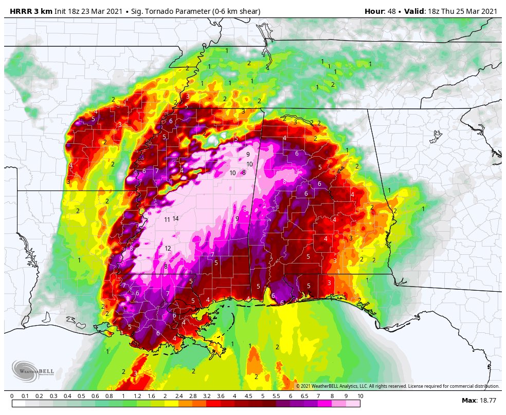
STPs are crazy on the HRRR
A reminder that the wxbell calculation of STP is off due to improper input parameters, it is usually far higher than outputs on any other site.
MNTornadoGuy
Member
Pivotal Weather has a max STP value of ~7 on that same run of HRRR
warneagle
Member
Southern MS/AL could also have some major flooding issues by the end of this, there are some pretty massive rainfall totals down there.
KevinH
Member
To me, Northern/Central Alabama and Mississippi always seem to get the worst of storms. Not just for the past week, but overall. I live in Columbus, Georgia and we do NOT get the kind of storms and threats these parts of Dixie Alley do (yes, I am going to still call Dixie Alley, DIXIE ALLEY. Screw The Weather Channel and Byron Allen).
On Twitter, I suggested that N AL and MS *SPECIFICALLY* have a nickname of their own to distinguish them from the rest of Dixie: #AlabamaAlley
I mean, I am JUST saying *shrug*
On Twitter, I suggested that N AL and MS *SPECIFICALLY* have a nickname of their own to distinguish them from the rest of Dixie: #AlabamaAlley
I mean, I am JUST saying *shrug*