
Kory
Member
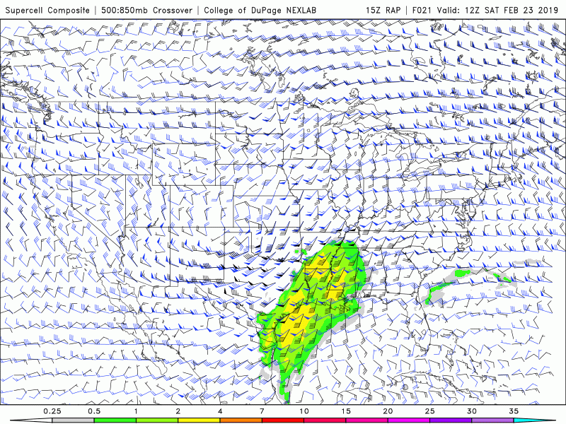
The HRRR is showing a pretty nasty environment across the whole warm sector. Long track supercells in East AR tracking into the bootheel of Missouri. Also showing confluence bands with supercells across MS and AL.
Follow along with the video below to see how to install our site as a web app on your home screen.
Note: This feature may not be available in some browsers.
yea. spc basically scalled back the enhance just off the 0z nam... one model run showed instability wasn't alarming... could be a big mistske... see if they back peddle and add it lunch update...The HRRR is showing a pretty nasty environment across the whole warm sector. Long track supercells in East AR tracking into the bootheel of Missouri. Also showing confluence bands with supercells across MS and AL.
North MS/East AR/and West TN continue to look like the bullseye. I think they could expand the risk more north and west, but overall, looks good to me.
12Z ("long-range") HRRR looks like it really means business, with discrete cells with strong UH streaks from southern IL down to central MS. However, that is at the very end of its range. 12Z 3KM NAM is less impressive (I'm used to that being the great gung-ho severe model).
wow latest 3k nam has dew points in the upper 60s after noon Memphis area...The 3KM NAM has steadily increased the intensity, and number of helicity streaks with each new run. I’d look for that to continue today.
Using today, and the past few days as examples the warm sector instability has been under appreciated by the models.
that was a moderate risk correct? across portions of southern tn north ms and north Alabama?I always get a bit leery when the energy pulls NE very quickly from the Southen Plains to the Great Lakes without significant eastward progression of the trough. Just brings me back to 12/23/15. Not saying that will be the case this time...
I always get a bit leery when the energy pulls NE very quickly from the Southen Plains to the Great Lakes without significant eastward progression of the trough. Just brings me back to 12/23/15. Not saying that will be the case this time...
Yeah, that was the day of the long track EF4 that hit Holly Springs, MSthat was a moderate risk correct? across portions of southern tn north ms and north Alabama?