
Navigation
Install the app
How to install the app on iOS
Follow along with the video below to see how to install our site as a web app on your home screen.
Note: This feature may not be available in some browsers.
More options
-
Welcome to TalkWeather! We see you lurking around TalkWeather! Take the extra step and join us today to view attachments, see less ads and maybe even join the discussion. CLICK TO JOIN TALKWEATHER
You are using an out of date browser. It may not display this or other websites correctly.
You should upgrade or use an alternative browser.
You should upgrade or use an alternative browser.
Severe WX Severe Risk 2/23-2/24
- Thread starter Xenesthis
- Start date
-
- Tags
- severe severe 2/23
Bama Ravens
Member
Off topic, but @WesL I am not seeing this thread when I go to the general weather discussion board. I can only get to it from the TW homepage when it shows up as the most recent post in the general weather discussion board.


rolltide_130
Member
Still awaiting the smaller details, but so far the 12z Euro may be yet another step in a dangerous direction.. trough and sfc low both look even better today.
NWMSGuy
Member
Are the models showing anything now that would give clues to the enhanced risk area being upgraded further?Still awaiting the smaller details, but so far the 12z Euro may be yet another step in a dangerous direction.. trough and sfc low both look even better today.
tennessee storm chaser
Member
- Messages
- 1,871
- Reaction score
- 4,275
- Location
- jackson tennessee
- Special Affiliations
- SKYWARN® Volunteer
I can see it going moderate by Saturday morning spc update swoodyAre the models showing anything now that would give clues to the enhanced risk area being upgraded further?
rolltide_130
Member
Euro is a dangerous setup for MS and even stretching into AL now... multiple supercells fire off a dryline-like feature near the MS river and track northeast throughout the day Saturday without ever really forming into a line inside a highly sheared environment... this is trending in a bad direction.
NWMSGuy
Member
Not liking the sound of that.Euro is a dangerous setup for MS and even stretching into AL now... multiple supercells fire off a dryline-like feature near the MS river and track northeast throughout the day Saturday without ever really forming into a line inside a highly sheared environment... this is trending in a bad direction.
tennessee storm chaser
Member
- Messages
- 1,871
- Reaction score
- 4,275
- Location
- jackson tennessee
- Special Affiliations
- SKYWARN® Volunteer
Memphis west Tennessee look have window to watch also for super cells out ahead the lineEuro is a dangerous setup for MS and even stretching into AL now... multiple supercells fire off a dryline-like feature near the MS river and track northeast throughout the day Saturday without ever really forming into a line inside a highly sheared environment... this is trending in a bad direction.
ECWF also has a much more favorable 700/500mb trough position for an outbreak in Dixie.Euro is a dangerous setup for MS and even stretching into AL now... multiple supercells fire off a dryline-like feature near the MS river and track northeast throughout the day Saturday without ever really forming into a line inside a highly sheared environment... this is trending in a bad direction.
NWMSGuy
Member
Snippet from the Memphis AFD:
Saturday...the aforementioned warm front will shift north of the
area...allowing for a jump in temperatures and dewpoints. Have
lowered rain chances in the morning hours across the southern
counties as they will be much deeper in the warm sector by then.
As the surface low shifts into the Midwest during the day it is
progged to deepen to 993mb by 23/18z and 988mb by 24/00z...so
nearly a millibar per hour. This will only increase the gradient
wind field over the area...with a wind advisory likely. Now for the
severe potential. Models are in good agreement that CAPE amounts
will range between 300-800 j/kg during the afternoon...with
greater disparity in helicity amounts....200 to as much as 600
m^2/s^2. Thus the overall tornado threat for the Midsouth is just
not in focus yet. The straight line winds though are...as a
midlevel jet of 100+kts and a low level jet of 65+kts overspread
the area. Storms will likely fire up on the Pacific cold
front/Pseudo dry- line over central Arkansas midday
Saturday...with models surging these storms to the Tennessee River
by 6pm. That`s a storm motion of nearly 65mph. Bowing segments
are expected with perhaps a fair amount of the Midsouth receiving
wind damage. Confidence of any discrete storms out ahead will
only occur if a few hours of sunshine can be realized...otherwise
the tornado threat will be undercut from the increasing stronger
linear shear along the front. This would provide for weaker
intensity...fast moving and briefer life-spans for any spin-ups.
NWMSGuy
Member
This talk about a dry-line is concerning to me.
Austin Dawg
Member
This talk about a dry-line is concerning to me.
Most of the big weather events happen to my east, we have high DRY winds out of the Pacific/southwest us here in South Central Texas in behind the front, rather than the usual cold fronts with northerly high winds. We get air warming fast with very high winds from the West. I don't want to alarm anyone but that is one thing that sticks in my mind from the 2011 system. We were having 30-45 mph winds out of the West. Saturday's post pacific front forecast is 35 mph West winds and warming temperatures.
There appears to be a sizable weakness in the mid level (2-6 km) storm relative wind concerning this event as forecast by the 18 UTC models. Also, it is quite possible that this will be a rare situation where the 350-250 mb storm relative flow will be too strong, suggesting the possibility of too much precip being shed downwind of storm cores (Thompson 1998). Not for certain, however definitely something to monitor. A meteorologist from my past taught me to pay close attention to details within the storm relative flow, especially in situations where storm relative helicity does not reflect the wind profile as a whole. Often times you can dismiss some of these guidelines when buoyancy is high, however I doubt this will be one of those times. Time will tell..
Last edited:
- Moderator
- #55
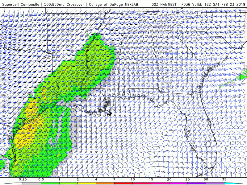
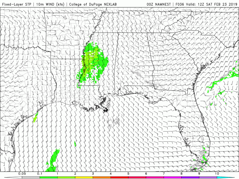
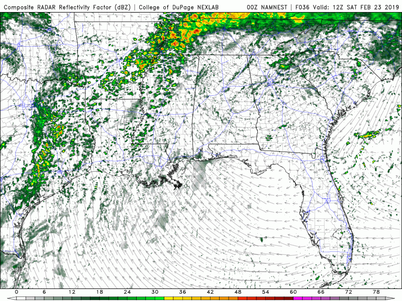
The 00z 3K NAM came in strong. A long string of discrete supercells developing down the Mississippi River valley, and advancing east.
- Admin
- #56
- Messages
- 3,618
- Reaction score
- 3,431
- Location
- Fayetteville, AR
- Special Affiliations
- SKYWARN® Volunteer
Weird, I see it. Just manually kicked off all the cron jobs. Let me know if you see it now. Thanks for letting me know.Off topic, but @WesL I am not seeing this thread when I go to the general weather discussion board. I can only get to it from the TW homepage when it shows up as the most recent post in the general weather discussion board.
Wouldn't this be supportive of a EML? Not that it will make a difference from what we are expecting.Most of the big weather events happen to my east, we have high DRY winds out of the Pacific/southwest us here in South Central Texas in behind the front, rather than the usual cold fronts with northerly high winds. We get air warming fast with very high winds from the West. I don't want to alarm anyone but that is one thing that sticks in my mind from the 2011 system. We were having 30-45 mph winds out of the West. Saturday's post pacific front forecast is 35 mph West winds and warming temperatures.
jmills
Member
Bama Ravens
Member
It still isn’t showing up. It’s there if I look while logged out, but not if I’m logged in.Weird, I see it. Just manually kicked off all the cron jobs. Let me know if you see it now. Thanks for letting me know.
warneagle
Member
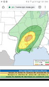
They’ve also removed the strong tornado wording from the outlook for now.