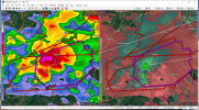
• Welcome to TalkWeather!
    We see you lurking around TalkWeather! Take the extra step and join us today to view attachments, see less ads and maybe even join the discussion.
    CLICK TO JOIN TALKWEATHER

Severe WX Multi-day Severe Weather Threat 3/12-3/14/2019

Not surprised at all that the St. Clair storm has been warned. It was pretty gnarly as it came over here, trying its best to touch down but the conditions weren't right at that time.
 
If they can survive the lack of instability further east, the shear just gets stronger and stronger going to the NE. Wouldn't be shocked to see a couple more touchdowns.
 
That looks very much like a TDS, overlapping the couplet perfectly... which is now several pixels closer, even
 
Obviously not anywhere near the same level, but this is a path very similar to the path taken by the Tuscaloosa-Birmingham-Ohatchee tornado on April 27, 2011.
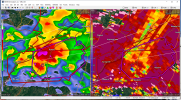
Yep. That one went right over my house here and so did this one. I was driving in from Roebuck when I heard this storm today get mentioned on the police scanner. It was in Gardendale at that time and the clouds and colors of it were extremely ominous as it moved over Pinson and Clay to the north of me.


Just heard confirmation via ham radio. Near Ashville.
 
Hopefully just trees damaged, brief but potent lil touchdown there. if trends continue may lift before hitting Ragland because that's right in the path. Couplet broad now.
 
Reminds me of that Cairo, GA hit on the 3rd. TDS over a town is never good news
 
TDS is less distinct now but still there. On its current track it would pass through Beecher, which was where the F5 in June 1953 hit.
 
Back
Top