- Thread starter
- #321
Yeah. Me neitherI'm a little surprised to get trimmed out of the 30% but i'll take it. However, i'm not confident that'll last all the way
Follow along with the video below to see how to install our site as a web app on your home screen.
Note: This feature may not be available in some browsers.
Yeah. Me neitherI'm a little surprised to get trimmed out of the 30% but i'll take it. However, i'm not confident that'll last all the way

.png")
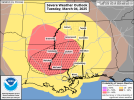
I think they’ll keep it enhanced. This is one of those conditional set ups with a very low floor but if things line up could have a decent ceiling.I think these are fairly reasonable. I think we could still see a moderate risk by the day of, once all the details get ironed out. View attachment 34432View attachment 34433
I definitely could still see a small moderate though.I think they’ll keep it enhanced. This is one of those conditional set ups with a very low floor but if things line up could have a decent ceiling.
You’re seeing a real downtrend of the models over the past few runs.
Definitely the right call with what the models have been showing. Very low floor, especially with the Euro downtrending on the instability.Not even hatched. They are definitely trimming this back some
15z rap is coming out now it's the newest mesoscale model to come on board for this event, I'll be curious to see how it looks in comparison to others currently.I see models have continued their tendency to downtrend significantly nearing the time of the event. #2024ing
Excellent discussion from JAN.NWS Jackson morning discussion
"Tuesday: A potent shortwave will eject across the southern plains
Tuesday, supporting a deepening surface low in southern Kansas. A
large low level jet will overspread the area, accelerating Gulf
moisture northward. Residual low level dry air in the east is
leading to a more pinched off warm sector further north. As a
result, the main threat for severe weather has migrated a bit
south. The enhanced risk in HWO has been adjusted accordingly to
fit this latest development. The jet dynamics aloft will result in
very strong windfields overspreading the warm sector, more than
ample for organized storms. Large, curved hodographs (400-600
m^2/s^ 0-3km helicity) in the midst of mid 60s dewpoints will be
supportive of tornadoes, possibly strong. Moisture appears
maximized along the MS river and south of I-20 and this should
correspond with greatest severe threat. There remains a bit of
uncertainty regarding storm mode and whether or not discrete
supercells will develop ahead of the main squall line. Some early
short range guidance is hinting at this possibility, however,
especially southwest. Should they develop, they would be capable
of all hazards, including tornadoes, maybe even a significant
tornado. The environment will continue to be favorable and
supportive of all hazards as the line pushes through Tuesday
afternoon and evening. Perhaps the most notable development this
forecast update is the possibility for enhancement further south
and east, generally along the HWY 59 corridor Tuesday evening as
the low level jet intensifies with good trajectories and the mid
level speed max arrives. Heights will be favorable in this area
and surface dewpoints should remain in the mid 60s. There appears
to be increased tornado threat for this area as well. Will have to
monitor this for more developments. Expect the forecast to
continue to be fine tuned as get closer."
Maybe early, but I would not want to be in South Mississippi or South Alabama.Not even hatched. They are definitely trimming this back some


I wonder if it's because of storms moving thru quicker due to the fast motion of the mid levels, but even that doesn't make sense. Squall line, impressive shear, and strong gradient winds mean that the winds are gonna be the biggest threat here. That's not to downplay the tornado threat because that's a given in reference to North MS.Not sure what the deal is, but most of the models, the NAM being the best example, have convection well outrunning depicted instability, especially as it moves eastward into AL. Not sure if it's just a weird modelling issue or not; it could certainly happen in theory, but it looks rather unusual.
View attachment 34446View attachment 34447View attachment 34448View attachment 34449