
Austin Dawg
Member
Wow.
Incredible
Follow along with the video below to see how to install our site as a web app on your home screen.
Note: This feature may not be available in some browsers.
Wow.
I can only guess not knowing the floorplan, but modern homes are big on open spaces; this could have been an entrance hall. The missing portion could have been essentially open from floor to roof with a cathedral ceiling. Those are almost always made by stacking two normal-height walls up, leaving a great weakness in the middle. I'm sure more details will emerge with the survey.Can anybody explain how the heck the picture above happened? Satellite tornado..? Or something?
Probably gonna have like...6 or 7 ef3’s when it’s all said and done
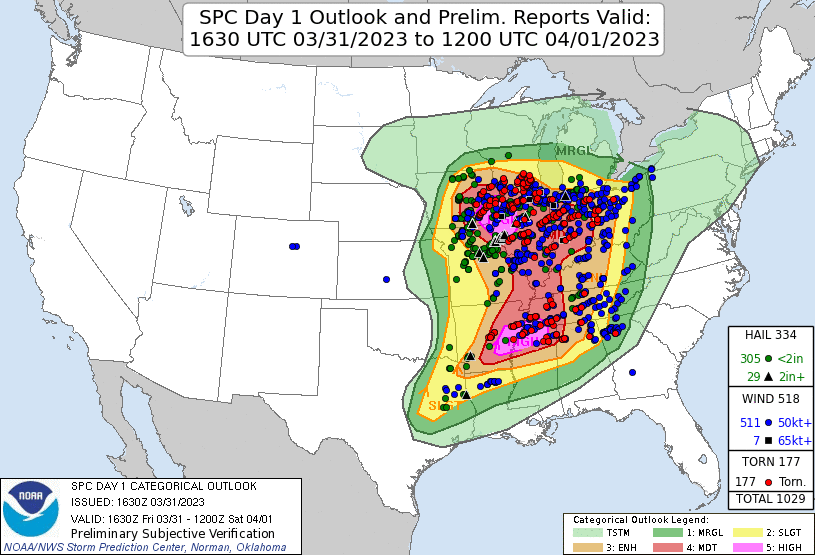
The total will likely reach eight or more once the Ellendale DE event is counted. Adamsville–Clifton and Covington TN, along with Wynne AR, probably produced EF3+ damage somewhere. If the Stinesville IN tornado were rated EF3+ and counted separately from the Sullivan event, the total would certainly be even higher. In all this outbreak likely generated more than twenty EF2+ tornadoes.

Right!!!! smhShe's lucky it wasn't "play stupid games, win stupid prizes."
Oh boy...The Sullivan tornado is being bumped to 165 mph ef3 per damage points just added to the dat this morning
Not expecting an ef4 rating though. As the high end ef3 structures weren’t anchored well at allOh boy...

Yeah, based on my own uneducated guess, we may have one or two more storms from Friday with the chance to be rated EF4. I think there may still be some DIs coming from the southern mode that could yield an upgrade. I mean one EF4 during an outbreak isn’t anything to sneeze at as well.I wonder if one of the tornadoes from the Sullivan storm will eventually be rated EF4. I remember seeing somewhere a two storey house was destroyed, with some significant contextual damage. Can't remember which tornado that was though.
Speaking of the Sullivan tornado, I still haven't seen any damage photos from Robinson, IL - per the DAT it made a direct hit on a cluster of homes (some fairly sizeable) at N 1100th St and Deer Creek Rd. There were also fatalities in that area.I wonder if one of the tornadoes from the Sullivan storm will eventually be rated EF4. I remember seeing somewhere a two storey house was destroyed, with some significant contextual damage. Can't remember which tornado that was though.

