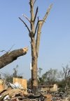
Just catching up this morning, a lot to take in. Aerials from Rolling Fork are horrifying, probably significantly worse than I expected even. Feels like easy low EF4 maybe mid to hid-high EF4 but don't see anything slam dunk structurally or contextually that would bring it higher than that without detailed engineering analysis, though I could easily be wrong. Just hard to have anything in a small town built strongly enough to show off EF5 level DoD without being overbuilt. Lots of obliterated houses but not much clean sweeps or extreme high end vehicle damage like you'd see in 190+
Relieved that Amory fared better than initial reports seemed to indicate, perhaps EF2 to locally EF3 in town itself? But very interested in seeing southwest of town where the signatured seemed most intense, that is a very rural stretch south of New Wren but I'd bet the most intense damage would be there. Not sure if MEG will survey that as the last violent New Wren tornado back on 4/27 got kind of ignored; hopefully it'll be detailed.
As for the meteorology of the event and why only literally one supercell managed to sustain and produce, that will be very interesting to go through in coming days; I think one of the working theories is related to some rather sudden warmth issues in the 850-700mb layer as seen by soundings taken, which really cut lapse rates and low level instability even despite the initially steep low level rates, seems like we have a case of a storm only being able to develop in a different environment over LA and moving into MS with an established meso to take advantage of it; the one cell that developed near Jackson struggled heavily in really marginal instability (brought some lightning and gusty winds here before it died though)