
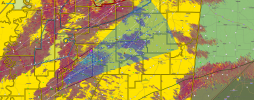
The oxford warning looks pretty bad...
Navigation
Install the app
How to install the app on iOS
Follow along with the video below to see how to install our site as a web app on your home screen.
Note: This feature may not be available in some browsers.
More options
-
Welcome to TalkWeather! We see you lurking around TalkWeather! Take the extra step and join us today to view attachments, see less ads and maybe even join the discussion. CLICK TO JOIN TALKWEATHER
You are using an out of date browser. It may not display this or other websites correctly.
You should upgrade or use an alternative browser.
You should upgrade or use an alternative browser.
Severe WX March 23-25th, 2023
- Thread starter Lake Martin EF4
- Start date
SmokeEater
Member
There's a lot more then just one injury there, that's the only one that has made a storm report so far.People are reportedly trapped in a truck stop near Rolling Fork, with at least one injury reported.
Sent from my SM-S901U using Tapatalk
kcyalater
Member
that tchula cell is an absolute unit
Justin Hindman
Member
- Messages
- 378
- Reaction score
- 1,165
- Location
- Gardendale Alabama
- Special Affiliations
- SKYWARN® Volunteer
- ARRL Member
I don’t see how their won’t be a loss of life  , just searched a mobile home , all that was left was the slab, found a lot of Guns and items, no people, hopefully they were at a shelter
, just searched a mobile home , all that was left was the slab, found a lot of Guns and items, no people, hopefully they were at a shelterAttachments


CheeselandSkies
Member
Yet another bizarre evolution of an event compared to expectations...
Far fewer reports than the outlooks and CAM depictions would have suggested (mainly in AR/LA which are pretty much done for the event), but significant destruction along the path of the "storm of the day."
Far fewer reports than the outlooks and CAM depictions would have suggested (mainly in AR/LA which are pretty much done for the event), but significant destruction along the path of the "storm of the day."
Storm Prediction Center Today's Storm Reports
Severe weather, tornado, thunderstorm, fire weather, storm report, tornado watch, severe thunderstorm watch, mesoscale discussion, convective outlook products from the Storm Prediction Center.
www.spc.noaa.gov
warneagle
Member
New circulation might be forming back near Midnight. IF that produces that's basically the worst scenario you could ask for because it'll be right on the same path.
- Thread starter
- #968
Lake Martin EF4
Member
WAIT WHATtornado/TORNADO EMERGENCY
Definitely looks fishy.New circulation might be forming back near Midnight. IF that produces that's basically the worst scenario you could ask for because it'll be right on the same path.

warneagle
Member
That northern storm is passing right over Oxford. Hopefully it isn't producing.
Very strong rotation on itThat northern storm is passing right over Oxford. Hopefully it isn't producing.
- Moderator
- #972
Anyone heard from Justin?!??
Equus
Member
Original tornado seems to still be down; for a moment looked as though inflow was getting closer again and we had an occlusion failure but still seems like new meso is trying to form

warneagle
Member
Damage in Silver Lake
TH2002
Member
- Messages
- 4,973
- Reaction score
- 11,113
- Location
- California, United States
- Special Affiliations
- SKYWARN® Volunteer
Tchula cell ramping back up.

- Admin
- #977
He responded just a little bit agoAnyone heard from Justin?!??
warneagle
Member
Yeah he posted in this thread a few minutes agoAnyone heard from Justin?!??
Jetstream
Member
Michelle, look a few posts up. He just posted pics
Looks like a potential TDS on oxford or portions of west oxford