
Navigation
Install the app
How to install the app on iOS
Follow along with the video below to see how to install our site as a web app on your home screen.
Note: This feature may not be available in some browsers.
More options
-
Welcome to TalkWeather! We see you lurking around TalkWeather! Take the extra step and join us today to view attachments, see less ads and maybe even join the discussion. CLICK TO JOIN TALKWEATHER
You are using an out of date browser. It may not display this or other websites correctly.
You should upgrade or use an alternative browser.
You should upgrade or use an alternative browser.
Archive March 18-20th, 2018 Severe Weather
- Thread starter Taylor Campbell
- Start date
-
- Tags
- severe weather
SilentShadow87
Member
Yeah it was obviously no 4/27/11, but there have been several damaging tornadoes and large hail which has, in my opinion, verified the moderate risk. The Jacksonville tornado is looking like an EF3 to me (although we said the same thing about the EF2 tornadoes on February 24).
ARCC
Member
You did a great job on pointing out the dry air intrusion you saw on the models. For awhile it looked like it might not come to play, but it did and you were talking about well in advance. Good job.
As always, we were perhaps 1 or 2 things shy of a much higher end event. Thank goodness the storm mode didn't start out completely discrete and endure that was for hours.
I certainly didn't expect the dry air to have this much effect though. I was more in the line of thinking mixing may have am effect on surface dewpoints. I think it added up to multiple problems with the setup away from the few places it come together for. It was easy to see the insane wind fields and instability and as you said, miss the small thing or two that impedes the outbreak. Really shows how rare events like 4/15/11 and 4/27/11 are.
Evan
Member
Yeah it was obviously no 4/27/11, but there have been several damaging tornadoes and large hail which has, in my opinion, verified the moderate risk. The Jacksonville tornado is looking like an EF3 to me (although we said the same thing about the EF2 tornadoes on February 24).
Very possible the worst damage is in a less populated/accessible area as a poster alluded to earlier. So far I haven't seen anything that screams more than an EF-2 to me. Assuming, of course, the wild guesses I'm making about construction quality are in any way accurate. Perhaps the church, if constructed better than a lot of similar churches I've seen, might be on the higher end of EF-2 to low EF-3. But that's just a wild guess because some of those church buildings like that are pretty weak structures.
Suffice to say we won't really know until the survey is complete. EF-3 damage somewhere wouldn't shock me. Neither would not finding damage over an EF-2. I've seen EF-3/EF-4/EF-5 damage up close and personal. EF-3 in Arkansas that we chased as well as an EF-3 down the road from my house on 4/27/11. Also, the EF-4 in Pleasant Grove. Saw my first up close and personal EF-5 damage the night of 04-08-98 (which started my real passion for weather) driving home from church and being unable to pass down Minor Pkwy in, Edgewater, doubling back to close to Pratt City, and then Oak Grove and PG/Sylvan Springs a few days later. Also saw Hackleburg/Phil Campbell in person a few weeks later.
I've also seen EF-0/EF-1/EF-2 damage quite a few times. I say all that to say that even with what I've seen in the past, nothing I've opined about tonight's damage is anything more than a slightly educated guess at best, but definitely nothing more than that. It's incredibly difficult to rate damage by looking at photos as we've all heard/seen a thousand times before. And I'm certainly near the bottom tier of being able to do so myself.
I will say, however, that I'll never be convinced that the Tuscaloosa/PG tornado wasn't an EF-5, but as I said my level of expertise is just slightly better than a random member of the general public.
So, we'll see. I definitely don't disagree with you that an EF-3 is out of the realm of possibilities. It's possible.
Evan
Member
I certainly didn't expect the dry air to have this much effect though. I was more in the line of thinking mixing may have am effect on surface dewpoints. I think it added up to multiple problems with the setup away from the few places it come together for. It was easy to see the insane wind fields and instability and as you said, miss the small thing or two that impedes the outbreak. Really shows how rare events like 4/15/11 and 4/27/11 are.
Still, you saw it and strongly suspected it would be a major issue for certain areas. Kudos on that. I think we are all here to learn! I sure did.
I would like to understand why the storms formed just a little too close to each other and then were rarely able to maintain separation. The Madison storm and the Jacksonville storm to a lesser extent were two of the ones that broke away or initialized away from the blob, and we saw what that led to.
Why did the storms form a little too close to begin with? Why were almost all of them unable to maintain any real separation? What led to all of that, or what was the missing ingredient (or too much of an ingredient perhaps) that prevented us from seeing more discrete storms?
When things calm down it would be great if Matt Grantham ever saw this and stopped by to opine.
ARCC
Member
I'd say low end EF2 on the church. Looks like the roof lifted off and the heavy brick vaneer just folded over.
Evan
Member
I'd say low end EF2 on the church. Looks like the roof lifted off and the heavy brick vaneer just folded over.
If it's constructed like quite a few similar church buildings I've been in I wouldn't disagree at all. The WAY it was damaged and the parts damaged seem to give a lot of credibility to your theory. There always seems to be a pretty sharp line between EF-2 and EF-3 to me. Sure, I've been fooled before, but EF-3 always seems to look a good bit worse to me than an EF-2 unless it's right there at the margins of both.
Well, bed time for me. Seems pretty likely we avoided any fatalities. Thank God for that. Hate it for the people with damage to their homes, businesses, churches, and schools. 4/27/11 left me with around 75k of damage to my 7 year old home if I'm remembering accurately. It really sucked and unfortunately no repair ever brings you back to 100%. Assuming it's repairable, of course.
Edit: was looking at hail pics on Twitter before crashing. I don't know how many people here have experienced Tennis/Baseball size hail, but I don't recommend it. It's nerve racking and not even remotely fun. It's a "WHEN will this end?!" type of experience. I'm hearing there is a lot of hail damage around Cullman. Hail of that size racks up damages in the millions very quickly. Nasty stuff.
Last edited:
barcncpt44
Member
Video from Brett Adair of the Jacksonville damage.
RF16Gold
Member
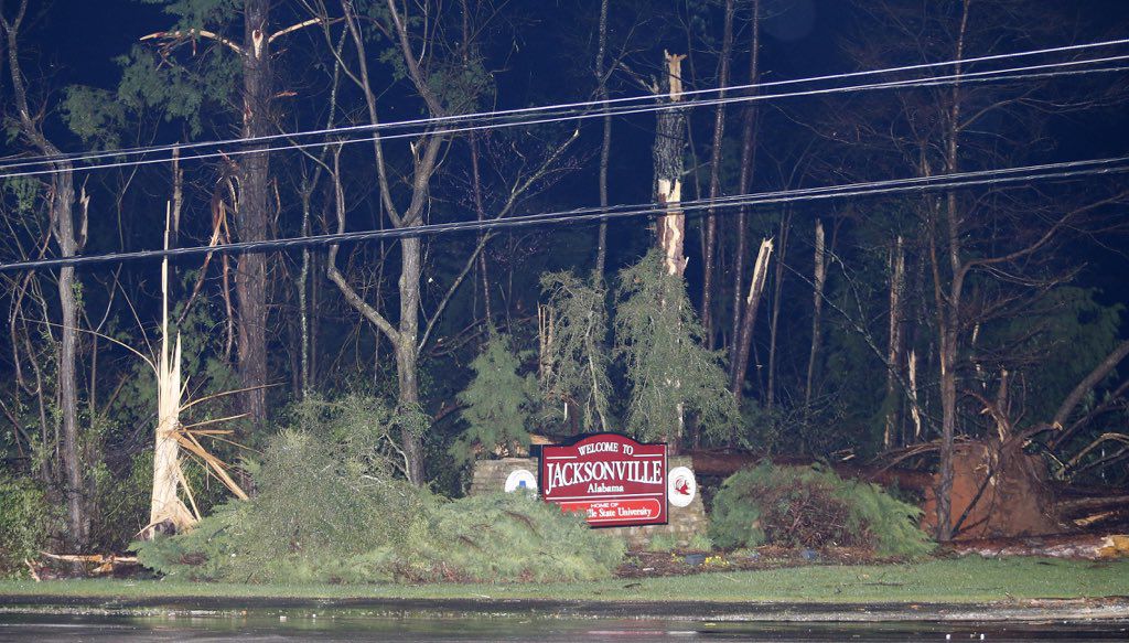
Just returned from Jacksonville. Damage is more widespread than people think. Tons of tree and power line damage/debris in neighborhoods blocks and blocks from campus. Jacksonville Church of Christ also damaged, similar to West Point Baptist. Coliseum, Merrill Hall, Logan, Paterson, and Mason Halls all damaged. Not sure if they are repairable. New baseball stadium was under construction and was hit.
Much damage for miles back down 204 toward Wellington. Many homes destroyed. Also over the mountain in Nances Creek homes damaged. Not to mention what will be found in the mountains in Cleburne County and also in Southside.
Word I am hearing is there may be deaths in Jville. I can tell you that they are still checking door to door . They are using the Wal-Mart in Jville as a staging area. It looks like a war zone in the north end of town. Rescue teams and equipment are coming from all over the state. Thank God this was Spring break week or we would have had a huge amount of injuries and deaths. Morning light is going to surprise folks about what has happened in East Alabama.
Last edited:
Gail
Member
Brett Adair is saying there are fatalities in Jacksonville on Facebook. 
As for the picture, maybe it was captured perfectly with a lightning strike. I’ve seen some that make the sky look like it’s the middle of the day before.
As for the picture, maybe it was captured perfectly with a lightning strike. I’ve seen some that make the sky look like it’s the middle of the day before.
Last edited:
Gail
Member
It will be interesting to see the public's response to how this played out in Central MS and Central AL. Last night and the first half of today it seems the severe threat was really hyped for this area and a lot of places closed early.
As usual, the mets will probably take a lot of heat for it. I hate it, not because I WANT bad weather in my area, but because people will use this as an excuse to not take future threats seriously. The general public doesn't understand the ingredients that have to come together for tornadoes.
I live north of Columbus, MS by the base, and Jackson NWS kept us in the slight risk the entire time, even when the PDS watch went up. They said we had a cap over our area that would be hard to break. That said, I work on the base in a flying squadron, and the base meteorologists had the planes moved to a safe location yesterday.
- Admin
- #992
- Messages
- 2,433
- Reaction score
- 2,270
- Location
- Meridianville, Al
- Special Affiliations
- SKYWARN® Volunteer
Maybe lightning enhanced it some or lights from the college and any nearby fields/stadiums?
I considered lightning but it just didn't look that way to me. I'm not saying for certain that's not the Jacksonville tornado, it just looks odd for the time of day.
- Admin
- #993
- Messages
- 2,433
- Reaction score
- 2,270
- Location
- Meridianville, Al
- Special Affiliations
- SKYWARN® Volunteer
Kory
Member
Yeah, this forecast was nailed. Not a bust at all.
ARCC
Member
Yeah, this forecast was nailed. Not a bust at all.
With all respect to SPC and the places that took damage, I can't agree. While the worst damage took place in the moderate threat area and that area was forecasted pretty well in advance, we can't forget that almost the entire north half of AL was under a high probability PDS watch with strong tornado wording down to Clanton. While obviously not a bust, it was not a nailed forecast. I'll chalk it up somewhere in between much like 3/1/07 and 4/7/06.
Bama Ravens
Member
CheeselandSkies
Member
LOL, Spann has a lot more class than I would.
So far, video on WBRC from the areas they have been able to access in Jacksonville look like EF2 at most. Big chunks of the top level of the buildings gone, but most exterior walls still present and vehicles parked out front battered/totaled but not relocated.
*Edit, later on they showed a couple of cars that were moved/overturned but they are not crushed/stripped to the frame like a car that was thrown a long distance by a violent tornado would be.
No other mentions of possible fatalities, yet.
Last edited:
Kory
Member
The PDS watch on 4/27/2011 extended down to Washington, Clark, and Monroe counties. Most of those places didn’t see a drop of rain, but I would say the overall forecast was nailed.With all respect to SPC and the places that took damage, I can't agree. While the worst damage took place in the moderate threat area and that area was forecasted pretty well in advance, we can't forget that almost the entire north half of AL was under a high probability PDS watch with strong tornado wording down to Clanton. While obviously not a bust, it was not a nailed forecast. I'll chalk it up somewhere in between much like 3/1/07 and 4/7/06.
Same goes for yesterday. We were a cap break away from what happened in East AL across all of Central AL. Even mesoscale guidance, such as the NAM and SREF, were indicating a cap break.
Helicity
Member
I'm no photography expert, but it is possible that the photo of the Jacksonville tornado is a still shot from a video clip. This would make it more likely that whatever is in the photo is being back-lit by lightning. Has anyone seen any video of the storm that the photo might fit into?
ARCC
Member
The PDS watch on 4/27/2011 extended down to Washington, Clark, and Monroe counties. Most of those places didn’t see a drop of rain, but I would say the overall forecast was nailed.
Same goes for yesterday. We were a cap break away from what happened in East AL across all of Central AL. Even mesoscale guidance, such as the NAM and SREF, were indicating a cap break.
While I agree to an extent, 4/27/11 lived up to the term it was billed as a wide scale outbreak. Yesterday at least in my mind will not reach the level of outbreak. If you take the moderate risk area out, you end up with a massive area and population centers where there were very few warnings at all.
Secondly we have to admit, despite the NAM showing the cap breaking, atleast to my memory all four CAMs did not and showed very little at all for the areas where nothing occurred.
Like I said, I can't call yesterday a bust just like I can't call 3/1/07 and 4/6/06 busts. But like those two events, I cannot say the forecast was a complete success based on initial wording.
I can't say they nailed the forecast just as I wouldn't say they Atmospheric Anti-Climax if they forecasted a slight risk and one lone supercell went Jarrell.