• Welcome to TalkWeather!
    We see you lurking around TalkWeather! Take the extra step and join us today to view attachments, see less ads and maybe even join the discussion.
    CLICK TO JOIN TALKWEATHER
  • April 2024 Weather Video of the Month
    Post your nominations now!
Logo 468x120

Archive March 18-20th, 2018 Severe Weather

AL_ham_op

Member
Messages
135
Reaction score
44
Location
Clay, AL
It will be interesting to see the public's response to how this played out in Central MS and Central AL. Last night and the first half of today it seems the severe threat was really hyped for this area and a lot of places closed early.

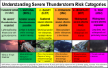
As usual, the mets will probably take a lot of heat for it. I hate it, not because I WANT bad weather in my area, but because people will use this as an excuse to not take future threats seriously. The general public doesn't understand the ingredients that have to come together for tornadoes.
 

Evan

Member
Messages
2,354
Reaction score
1,599
Location
McCalla, AL
Will definitely need more photos and to know exactly where the heaviest damage is, but from those pics *alone* it would be unlikely to be any stronger than an EF3 at most. But that's just a tiny sample and says nothing about damage elsewhere or construction quality, so it's a highly speculative opinion at best. Let's hope those pics represent some of the heavier damage
 

rolltide_130

Member
Messages
828
Reaction score
378
Location
Harvest, Alabama
Special Affiliations
Will definitely need more photos and to know exactly where the heaviest damage is, but from those pics *alone* it would be unlikely to be any stronger than an EF3 at most. But that's just a tiny sample and says nothing about damage elsewhere or construction quality, so it's a highly speculative opinion at best. Let's hope those pics represent some of the heavier damage

What particularly interests me is the valley east of town. After exiting the tornado climbed up a mountain and descended into a valley east of town where it hit peak intensity on velocity and the TDS absolutely exploded. If it hit any structures there I'm thinking that's where the most intense damage occurred.
 

MattW

Member
Messages
325
Reaction score
228
Location
Decatur, GA
HAM Callsign
KG4GUF
Special Affiliations
  1. SKYWARN® Volunteer
Rotation seems to be tightening up on the storm in Stockbridge, GA. Also some broad rotation near Snellville.
 

barcncpt44

Member
Messages
280
Reaction score
154
Location
Anniston, AL
Special Affiliations
  1. SKYWARN® Volunteer
Video of a church destroyed in Jacksonville, AL.
 

ARCC

Member
Messages
503
Reaction score
309
Location
Coosa county
This isn't the look I was referring to in my post above, but it's fairly close. At one point the HRRR accurately had Cullman, St. Clair, Marshall, Etowah, Calhoun, etc painted with highest SIGTOR values.

I wish I could find the exact map, but it is gone. I was messaging someone saying the HRRR said the risk would be NW AL shifting into Cullman and then into Dekalb, Etowah, Marshall, and Calhoun.

I guess if you pick one version of the HRRR you were liable to find one that was somewhat close. But that's the whole issue. It wildly changed its solutions numerous times and had initialization issues.


All the CAMs did fairly well. The WRFs were too hot, but they normally are, and the 3km NAM did alright as well. The NAM itself was far too bullish on the southern exent of the storms.

The SW surface winds likely hampered low level convergence, but the NAM for days has shown the dry air filtering in at 850mb and causing a very shallow moisture layer across central AL.
 

buckeye05

Member
Messages
3,354
Reaction score
5,215
Location
Colorado
Spann just shared a video of the Jacksonville tornado that he says he has vetted and it looks the same as that picture from earlier.
I saw it too. Looked like a backlit towering cumulus cloud in poor lighting to me. They should have looked at that video a little closer.
 

Evan

Member
Messages
2,354
Reaction score
1,599
Location
McCalla, AL
I commend SPC, the NWS offices, and local broadcast mets. They will surely get bashed because a lot of areas lucked out, but I feel that both the moderate risk and the PDS Tornado Watch both verified fairly well.

I agree. I would need to look back at the PDS probabilities, but I think a moderate risk was warranted. I count 8 hail reports in excess of 2" (although some may be dupes), and 3 TOR reports although the Franklin storm near Russellville is listed as a wind report. It may be that it never fully touched down. You normally have a few TORs show up the next day or two once survey teams start checking everywhere over where a potential TOR was thought to have hit. The 3 TOR listed are 2 in Cullman and the Jax St TOR. I think we likely also had 1 or 2 touchdowns in Madison with the Elkmont storm. I don't know if we will end up with any violent TORs unless Jax St qualifies in an area, but could likely see several EF-1/EF-2s and maybe Jax St ends up an EF-3, but just wildly speculating. I think estimating 4-5 TORs right now is probably somewhat accurate. That along with the hail and wind report mean the moderate will likely verify. I think the hail and TOR potential were too great to have gone with an ENH. Just doesn't fit it to me.

  • 4-MDT (red) - Moderate risk - An area where widespread severe weather with several tornado and/or numerous severe thunderstorms is likely, some of which should be intense. This risk is usually reserved for days with several supercells producing intense tornadoes and/or very large hail, or an intense squall line with widespread damaging winds.
 

Attachments

  • understanding_categories.png
    understanding_categories.png
    962.9 KB · Views: 0

Evan

Member
Messages
2,354
Reaction score
1,599
Location
McCalla, AL
All the CAMs did fairly well. The WRFs were too hot, but they normally are, and the 3km NAM did alright as well. The NAM itself was far too bullish on the southern exent of the storms.

The SW surface winds likely hampered low level convergence, but the NAM for days has shown the dry air filtering in at 850mb and causing a very shallow moisture layer across central AL.

You did a great job on pointing out the dry air intrusion you saw on the models. For awhile it looked like it might not come to play, but it did and you were talking about well in advance. Good job.

As always, we were perhaps 1 or 2 things shy of a much higher end event. Thank goodness the storm mode didn't start out completely discrete and endure that was for hours.
 

warneagle

Member
Messages
4,018
Reaction score
3,992
Location
Arlington, VA
Special Affiliations
  1. SKYWARN® Volunteer
Yeah, if we'd been discrete the whole way...don't want to think about that. It's been bad enough.
 

warneagle

Member
Messages
4,018
Reaction score
3,992
Location
Arlington, VA
Special Affiliations
  1. SKYWARN® Volunteer
The pictures in the morning will be “amazing” to see, especially in Jacksonville, AL.

To me, that's one of the worst parts about Dixie Alley events especially: having the worst damage come just before dark and knowing you're going to wake up in the morning to see something awful and having it on your mind all night.
 

Evan

Member
Messages
2,354
Reaction score
1,599
Location
McCalla, AL
I saw it too. Looked like a backlit towering cumulus cloud in poor lighting to me. They should have looked at that video a little closer.

Sunset was supposed to be around 6:55pm. The tornado hit Jacksonville around 8:30pm. Civil twilight ended around 7:18pm and nautical twilight ended around 7:47pm.

It does seem odd to me because of the lighting. I just don't see how there was that much natural light, but I could certainly be wrong as I have zero expertise or experience in this area.
 

Evan

Member
Messages
2,354
Reaction score
1,599
Location
McCalla, AL
Starting to see more impressive damage out of Jacksonville.


Evan

Member
Messages
2,354
Reaction score
1,599
Location
McCalla, AL
Maybe lightning enhanced it some or lights from the college and any nearby fields/stadiums?


Top