• Welcome to TalkWeather!
    We see you lurking around TalkWeather! Take the extra step and join us today to view attachments, see less ads and maybe even join the discussion.
    CLICK TO JOIN TALKWEATHER
  • April 2024 Weather Video of the Month
    Post your nominations now!

Archive March 18-20th, 2018 Severe Weather

warneagle

Member
Messages
3,887
Reaction score
3,601
Location
Arlington, VA
Special Affiliations
  1. SKYWARN® Volunteer
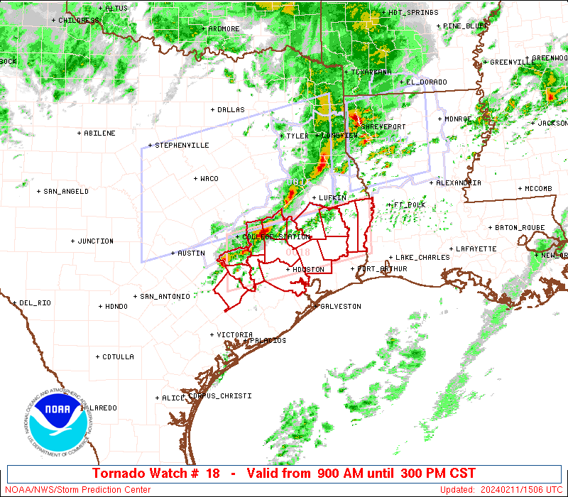
New SC/GA watch is up, 50/30 probs on this one. We might not be quite done with this system yet.

ww0018_radar_init.gif
 

Kory

Member
Messages
4,928
Reaction score
2,119
Location
Tuscaloosa, Alabama
Modified my quoted post a bit. I know at least one poster said veered winds are less of an event-killer in Dixie than in the Plains, but they still obviously have an effect.
We can get away with SSW winds and most outbreaks in Dixie are SSW/S winds. We don't need SE winds like the Plains does to advect moisture. SSW winds in Plains set ups are killer because it would be advecting drier air. Obviously our proximity to the Gulf eliminates the moisture issue associated with any westerly component in surface winds, but if they become too parallel to the boundary, you don't get convergence/it kills any low level rotation. Convergence wasn't much of an issue for last January's Florida event, but low level rotation couldn't sustain itself because of said unidirectional low level winds.

Had we seen more southerly component with low level winds yesterday, capping wouldn't have been much of an issue. I posted earlier in the morning regarding the dry air coming in from the WSW, which ended up capping most of West/Central AL. Mesoscale details/better low level flow didn't preclude a significant tornado threat yesterday in North and East AL and Western GA.
 

ARCC

Member
Messages
503
Reaction score
309
Location
Coosa county
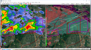
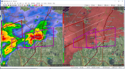
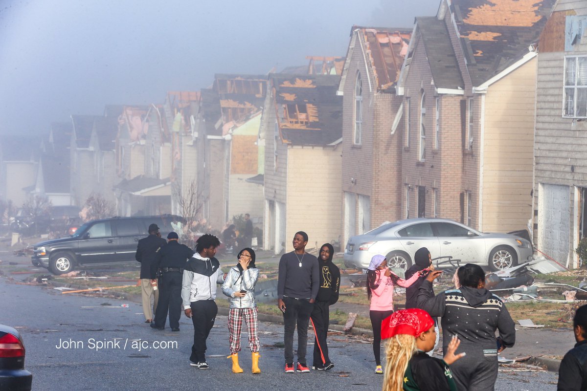
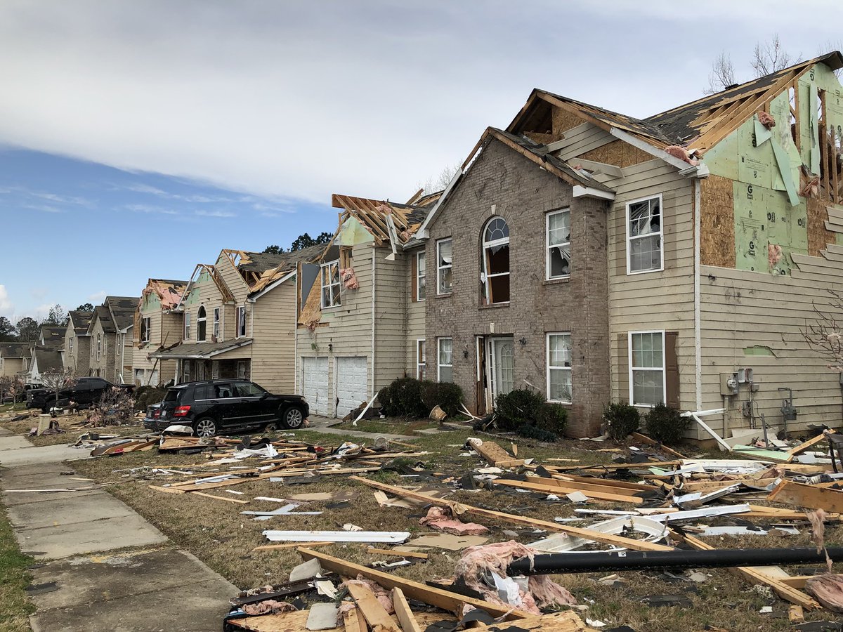
I know the big story seems to be the Jacksonville tornado, though the Atlanta suburbs also got hit pretty hard last night, particularly in Fairburn (southern Fulton County). There was a tight couplet and a significant debris signature in this area. Looks like high-end EF1 to EF2 damage.
DYvM5bVX4AEGKjW.jpg

DYvM5cyW0AA96Ic.jpg
DYvtThXVoAAd6sP.jpg

DYveZrYVoAE45Rv.jpg


One thing weaker tornadoes do is expose how easily things come appart. Lose the roof, and the walls just fall down.
 

ARCC

Member
Messages
503
Reaction score
309
Location
Coosa county
We can get away with SSW winds and most outbreaks in Dixie are SSW/S winds. We don't need SE winds like the Plains does to advect moisture. SSW winds in Plains set ups are killer because it would be advecting drier air. Obviously our proximity to the Gulf eliminates the moisture issue associated with any westerly component in surface winds, but if they become too parallel to the boundary, you don't get convergence/it kills any low level rotation. Convergence wasn't much of an issue for last January's Florida event, but low level rotation couldn't sustain itself because of said unidirectional low level winds.

Had we seen more southerly component with low level winds yesterday, capping wouldn't have been much of an issue. I posted earlier in the morning regarding the dry air coming in from the WSW, which ended up capping most of West/Central AL. Mesoscale details/better low level flow didn't preclude a significant tornado threat yesterday in North and East AL and Western GA.

Yep, and the crazy part is a SE wind can hamper an outbreak in the south by pulling in cooler, drier air from GA. I think Fred and I had this discussion years ago about this.
 

South AL Wx

Member
Meteorologist
Messages
310
Reaction score
315
Location
Wetumpka, AL
Special Affiliations
  1. SKYWARN® Volunteer
Could the hail that fell yesterday be the biggest ever recorded in Alabama? NWS Huntsville posted:

We are looking for the largest hail stone that fell in AL on March 19. Your hail stone could end up in the record books for the largest in Alabama! Please send pics, along with measurement of widest width. If you've saved it, we might even come take a look. #ALwx #HUNwx

I can't find the record for the biggest hail stone in Alabama. Does anybody know?

EDIT: I asked HUN, and they responded:

Good question! So, not every state has an official record for hail size. This has to go through a certification process. Unfortunately, Alabama is one of those states, but we're trying to establish a record.
 
Last edited:

buckeye05

Member
Messages
3,316
Reaction score
5,077
Location
Colorado
Jacksonville tornado rating upgraded to EF-3.


I guess those buildings that sustained exterior wall collapse at and around the university were very well-constructed. Though the assigned wind speed is 140 MPH, so sounds like it was pretty borderline.

Not convinced this was the first EF3 of 2018 though (looking at you OHX).
 

HazardousWx

Member
Messages
92
Reaction score
88
Location
Huntsville, AL
HAM Callsign
W4SSW
Special Affiliations
  1. SKYWARN® Volunteer
Went with NWS personnel today in Madison Co. to do the storm survey. The worst damage was 2 homes with large trees that fell on them and to the pole barns (storage buildings) next to ACE Hardware north of Hazel Green. Other than that, several large trees were uprooted - no doubt assisted by all the saturated soil.
 

Evan

Member
Messages
2,292
Reaction score
1,473
Location
McCalla, AL
I think 4/27 and a few other events have really distorted our perspective as it pertains to severe weather, SPC forecasts, etc. I'm sure as time passes that will calm down and recede into the background like the Super Outbreak did, but video and imagery as well as the overall media attention that 4/27 and other events received have given us a biased perspective.

Just my opinion. I think prior to 4/15, 4/27 and other recent significant events we'd be all feeling like this was a very major event that definitely verified the moderate. I'm not saying anyone is specifically questioning that now, but I definitely think the calculus has changed how we view events due to the fairly recent significant events and ability to see imagery and data from almost every event that transpires nowadays.

Fact is, yesterday was very close to being a truly bad day for a lot more people than it was, and we are lucky it didn't reach the ceiling that some of us thought was possible. I've mentioned this before, but 4/27 turned me off from the weather and chasing for a good while outside of necessity. After living it sometimes you just have a hard time even watching it happen again.

Be interesting to see all the final surveys once they are complete. Just imagine if we had EF-2s/EF-3s as the baseline and an EF-4. Thank God we didn't.
 

Evan

Member
Messages
2,292
Reaction score
1,473
Location
McCalla, AL
I didn't know this...


MichelleH

Moderator
Moderator
Messages
926
Reaction score
1,453
Location
Cullman, AL
I'm very, very thankful it didn't get as bad as we all thought it would. Not only for my own family (where the massive hail damage in Cullman County just barely missed us), but after seeing the damage in Cullman today and some videos from last night, it could have been a disaster with multiple fatalities again.

As most of you know, through the years, tornadoes seem to follow the same certain paths. Where the south Cullman Wal-Mart and surrounding businesses are located is one of those areas. I have been worrying about that for years and last night could very well have been that nightmare scenario if the conditions had been just a little more "perfect."

As it was, businesses in the area, including Wal-Mart, received massive damage from baseball size hail. The thing that REALLY bothers me though, is the fact that after all of the warnings for days ahead of time, the fact that we were in a PDS tornado watch and there were multiple tornado warnings (some with verified damage already)...Wal-Mart was full of customers. Some of them with their children. They took shelter under areas without skylights and watched and recorded on their phones as the hailstones trashed the store. Sigh. Some people are never going to learn, never going to listen, and then when one of their loved ones die...they will say they had no warning.
 

ARCC

Member
Messages
503
Reaction score
309
Location
Coosa county
I think 4/27 and a few other events have really distorted our perspective as it pertains to severe weather, SPC forecasts, etc. I'm sure as time passes that will calm down and recede into the background like the Super Outbreak did, but video and imagery as well as the overall media attention that 4/27 and other events received have given us a biased perspective.

Just my opinion. I think prior to 4/15, 4/27 and other recent significant events we'd be all feeling like this was a very major event that definitely verified the moderate. I'm not saying anyone is specifically questioning that now, but I definitely think the calculus has changed how we view events due to the fairly recent significant events and ability to see imagery and data from almost every event that transpires nowadays.

Fact is, yesterday was very close to being a truly bad day for a lot more people than it was, and we are lucky it didn't reach the ceiling that some of us thought was possible. I've mentioned this before, but 4/27 turned me off from the weather and chasing for a good while outside of necessity. After living it sometimes you just have a hard time even watching it happen .

I don't know, I remember plenty of discussion about how 3/1/07 and 4/6/06 were big time busts compared to forecast and the tornadoes that actually happened we much worse and more numerous than yesterday.

I tend to believe the opposite. Ever since 4/27 it has been quieter across the state and with a stronger tornado hitting a city it's bigger news than it would have been 7-10 years ago.
 

Fred Gossage

Member
Meteorologist
PerryW Project Supporter
Messages
687
Reaction score
2,762
Location
Florence, AL
Here's something interesting...

BMX.gif[

BMX.gif


Here's the 02Z balloon launch from BMX yesterday evening. Note the 0-1 km helicity values and the overall wind/shear profiles. It seems even the most aggressive models underplayed the shear at least a little bit (if not more) leading up to this event. Even in the absolute most aggressive models beforehand, these were the type of values that were projected as the isolated max values near the warm front in far northeast/east Alabama and further east. This is back at the NWS BMX office, deep into central Alabama... at 02Z, when the surface low was definitely starting to pull away.
 
Last edited:
Logo 468x120
Back
Top