rolltide_130
Member
Somebody somewhere said Clipper systems tend to usually underperform on snowfall totals. I don't remember who said it exactly, but they've been proven right before and it looks like that may happen again.
Follow along with the video below to see how to install our site as a web app on your home screen.
Note: This feature may not be available in some browsers.
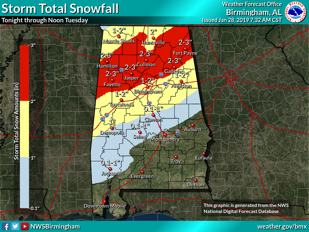
I'm seeing rates of 1-2" an hour in West AL and East MS with changeover. That will easily collect on surfaces.The hrrr is a good bit faster with the cold air.
I'm concerned about ground temps. It's 57 degrees and very sunny here right now. Can they drop fast enough?
The hrrr is a good bit faster with the cold air.
I'm seeing rates of 1-2" an hour in West AL and East MS with changeover. That will easily collect on surfaces.

Which is why runoff will be a problem (with initial rain before changing to snow)...and then temps drop below freezing.Lot of moisture in the ground still.
Yes, the real issue here is how much precip is behind the front. This is based on amount of surface convergence, and divergence aloft that we typically see with a positively tilted trough. This is a very energetic system and that could be underplayed by models.AL_ham, getting the temp down enough to snow should not be an issue except the final accumulation totals. The fact that it is 60 today is not unexpected. The front should be a game changer in and of itself and it will snow. If the bursts are heavy enough it will even accumulate before it reaches freezing(air temp) on some surfaces. The bigger question is where the sub-freezing air temps make it to cause the icing concerns on the roads.
Thanks to all of you posting model updates by the way...
Yes, the real issue here is how much precip is behind the front. This is based on amount of surface convergence, and divergence aloft that we typically see with a positively tilted trough. This is a very energetic system and that could be underplayed by models.


This is what I'm going with. I just don't see the temps getting cold enough quickly enough.18z NAM is running, and it's another bad run for central AL. It is slower with the surface cold, and still has it 37 in Birmingham at 12z as precip is moving out. Shows a few spotty accumulations where the heavier snow changed over, but overall little to nothing.
Oddly, it's slightly faster with the arrival of the cold air aloft, but slower at the surface.