- Admin
- #781
- Messages
- 2,432
- Reaction score
- 2,270
- Location
- Meridianville, Al
- Special Affiliations
- SKYWARN® Volunteer
Regardless of whatever happens here, I'm ready.

Follow along with the video below to see how to install our site as a web app on your home screen.
Note: This feature may not be available in some browsers.
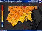
.SHORT TERM...
(Today through Saturday)
Issued at 138 AM EST Fri Jan 23 2026
Quite the temperature gradient is expected today across the
County Warning Area (CWA) with forecast highs in the 40s across
north Georgia and forecast highs in the 60s across central
Georgia. This is indicative of a front across the area, with low-
level moisture driving in a feed of light rain this morning.
Cloudy conditions will persist through the day, with light rain
becoming more isolated as drier air moves in aloft.
Saturday marks the onset of the impending winter storm, which is
covered in great detail in the long term discussion. Moisture
advection will begin in earnest on Saturday morning, overrunning
a cool, relatively dry surface airmass that will be courtesy of
arctic high pressure nudging in from the north and a developing
"wedge" (cold air damming) nudging in from the east. Forecast
soundings (from a mix of global, regional, and even hi-res models)
depict saturation of the dendritic growth zone (the part of the
atmosphere where ice crystal formation is maximized) with
relatively drier air in the mid-levels and low-levels. The result
will be evaporative cooling through the atmospheric column,
leading to a mix of precipitation types (frozen and liquid) across
north Georgia early to mid-morning, before temperatures warm to
above freezing during the late morning to mid-afternoon. As
precipitation falls into the developing wedge airmass across
northeast Georgia in the mid- to late afternoon, sleet and ice
(freezing rain) accumulations will begin.
&&
.LONG TERM...
(Saturday night through Thursday)
Issued at 138 AM EST Fri Jan 23 2026
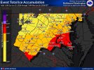
Ice Storm Overview
The primary change to the forecast overnight was the issuance of
an Ice Storm Warning for several counties in northeast Georgia.
The portion of the Winter Storm Watch upgraded to the Ice Storm
Warning represents the area were we are most confident in
major/prolonged impacts from ice accumulation. This area may
experience widespread power outages and treacherous travel
conditions by Sunday morning. Confidence in the timing and degree
of icing in Atlanta, along Interstate 75 north of Atlanta, and
Interstate 20 east of Atlanta was lower. Thus these areas and
their surrounding counties were left in a Winter Storm Watch for
now. We will reevaluate the current Watches and Warnings later
this morning and provide updates by early this afternoon. An
expansion to the Ice Storm Warning is probable at some point.
Wedge Intensity Saturday Evening & Sunday
Moderate to heavy precipitation is a virtual slam dunk (>99%
chance) during this period. Thus the areal extent and intensity of
the ice storm will be dictated by the strength of the wedge. An
intense surface high (near 1046 mb) over the Great Lakes and a
developing surface low along the Carolinas coast will ensure that
a strong wedge is in place by Saturday night across most of north
Georgia. Meanwhile within the wedge, northeast winds will lead to
strong CAA and dry advection. As precipitation falls into this
cool dry air, it will lead to strong evaporative cooling and
reinforce the wedge. It should also help keep temperatures below
freezing within the core of the wedge and lead to extensive ice
accumulations (especially along Interstate 85 and HWY 23 in
northeast Georgia) by Sunday morning. Model guidance continues
with significant erosion of the wedge on Sunday as a secondary
surface low developing along the Gulf Coast enhances southerly
flow in the mid-levels. Experience with past events suggests that
this is a common bias for the models and thus our forecast
continues to favor a stronger and more expansive wedge through
Sunday. As the low moves into Georgia during the day on Sunday
temperature gradients should tighten. Southerly warm air advection
may lead to temperatures in the 70s south of Macon, while
continued evaporative cooling should keep northeast Georgia in the
and lower 30s. It wouldn`t be surprising if the north to south
temperature spread over a 3 to 4 county distance reached 30
degrees at times Sunday afternoon. Given this thinking, freezing
rain should remain a hazard in northeast Georgia through the day
on Sunday.
Gusty Northwest Winds Sunday Night & Monday
An Arctic front will surge through Georgia Sunday night. This
feature will bring much drier air, sharp temperature falls and
gusty northwest winds to the region. The initial concern will be
the wind gusts that could increase the potential of downed trees
and power lines in areas that receive significant icing (mainly
northeast Georgia). Current guidance from the NBM suggests a 40 to
60% chance of 25 mph gusts Monday afternoon, while the odds of 35
mph gusts are lower (~10%).
Hazardous Cold Monday & Tuesday
The aforementioned front will usher very cold temperatures into
Georgia Monday night and Tuesday morning. A large snowpack to our
north over the Tennessee Valley and strong radiational cooling
should help intensify the cold as well. The result should be
morning lows in the single digits and teens on Tuesday. Combine
the cold with light northwest winds, and morning wind chills may
be at or below zero in north Georgia. There is a moderate
potential for a Cold Weather Advisory Tuesday morning and at least
a low risk of us needing to issue an Extreme Cold Warning. Anyone
without power during this period will be at an elevated risk of
cold related illness. The risk of pipes bursting would also be
elevated. Conditions will improve some Tuesday night, but
overnight lows in the teens and lower 20 are still anticipated.

Exact. Nothing above freezing here until first week Febtoday is the last day above freezing for us on the ten-day forecast and it's not going even to get out of the 20s until next weekend, so yeah, this snow is gonna be here for a while unfortunately


No way!
What I would hate is fore a situation similar to snowmageddon back in 2014 to happen and everybody get caught of guard with a surpriseA battle of the minds, models.. guesses.. wishes.. WPC map has mixed precip on Sunday almost down to Montgomery/Columbus GA.. FFC saying thunderstorms.. pretty wide spread still at 48 hours. Who is right?? My only guess in the huge difference is HRRR is what WPC must be using.. View attachment 50210

URGENT - WINTER WEATHER MESSAGE
National Weather Service Peachtree City GA
1214 PM EST Fri Jan 23 2026
GAZ013-020-021-030>039-043>051-055-057-062-241000-
/O.UPG.KFFC.WS.A.0001.260124T1800Z-260126T1500Z/
/O.EXA.KFFC.IS.W.0001.260124T1800Z-260126T1500Z/
Pickens-Bartow-Cherokee-Polk-Paulding-Cobb-North Fulton-Gwinnett-
Barrow-Clarke-Oconee-Oglethorpe-Wilkes-Douglas-South Fulton-
DeKalb-Rockdale-Walton-Newton-Morgan-Greene-Taliaferro-Clayton-Henry-
Warren-
Including the cities of Dallas, Woodstock, Riverdale, Conyers,
Cedartown, Jasper, Washington, Madison, Covington, Crawfordville,
Winder, Greensboro, Decatur, Cartersville, East Point, Athens,
Watkinsville, Crawford, Douglasville, Warrenton, Marietta, Monroe,
Atlanta, Stockbridge, and Lawrenceville
1214 PM EST Fri Jan 23 2026
...ICE STORM WARNING IN EFFECT FROM 1 PM SATURDAY TO 10 AM EST
MONDAY...
* WHAT...Significant icing expected. Total ice accumulations between
a quarter of an inch and one inch are expected.
* WHERE...Portions of east central, north central, northeast, and
northwest Georgia.
* WHEN...From 1 PM Saturday to 10 AM EST Monday.
* IMPACTS...Expect power outages and tree damage due to the ice.
Travel could be impossible. The hazardous conditions will impact
the Monday morning commute.
PRECAUTIONARY/PREPAREDNESS ACTIONS...
Travel is strongly discouraged. If you must travel, keep an extra
flashlight, food and water in your vehicle in case of an emergency.
Prepare for possible power outages. The latest road conditions for
the state you are calling from can be obtained by calling 5 1 1.
No thanks, please put that back where it came from.12ZNAMNST - a real squeaker... persistent CAD and the line.
View attachment 50212View attachment 50213
They issued that at 12:14, which is the exact same time down to the minute I texted my family to let them know things were trending slightly better for us. LOL. Weather gods have a sense of humor I supposeFFC has expanded the Ice Storm Warning and it now covers much of north Georgia.
I'm anxious to see/read everyone's comments on what did not verify next Monday. Edit - I guess on Saturday and Sunday also.The thing that is tugging at me the most is how just slight changes in this forecast would radically alter the outcomes. Low formation (which we don't know exactly how that cyclogenesis will go), track of the low, persistence of the CAD, strength of the high, LLJ 5-15KT error at 850mb - all factors that could be different than modeled that would radically change outcomes. Suffice to say there is still plenty to nowcast. A lot of questions will be answered by how the ACTUAL system evolves today. It will be nice to be able to look at something real instead of best guesses.
Well once this one's done I don't think there will be much time for a synopsis because there's a big event on the horizon next weekend it looks like in the winter weather world.I'm anxious to see/read everyone's comments on what did not verify next Monday.