"12z HRRR what the f**k man
1.2" before the second round even begins"
@Originwx
Follow along with the video below to see how to install our site as a web app on your home screen.
Note: This feature may not be available in some browsers.


We’re talking now!!! Did I move to Antarctica and didn’t notice??
View attachment 50220

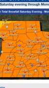
Just throwing this out there for some fun and I just think it is cool for nowcasting.
Years ago we placed our Jack Watkins Memorial Weather Station with our friends at Turpentine Creek Wildlife Refuge located near Eureka Springs, AR. With some winter weather approaching, some great ground truth is watching the cats play in the snow. They really love it.
Our station data -> https://talkweather.com/pages/jackwatkins/
Live camera ->
.DISCUSSION...
(This afternoon through Wednesday)
Issued at 1158 AM CST FRI JAN 23 2026
Today`s forecast update for the next 48 hours remains very much
status quo from the overnight shift, except for minor tweaks in
the hourly grids. First, the cold front that is bringing the first
round of arctic air southward has reached the I-20/59 corridor.
Colder and drier air will continue to advect southward through the
afternoon with perhaps a few peeks of sunshine across the U.S. 278
corridor. Otherwise, skies will remain mostly cloudy with
temperatures expected to drop down into the 20s across our far
northwest counties after midnight tonight. As precipitation moves
in from the west, we`ll continue to monitor for freezing rain
potential across Marion, Winston, Lamar, Fayette, and Walker
Counties after 6am Saturday morning.
We`ll then become "sandwiched" in between cold air to our
northwest where an ice storm may be brewing and cold air over
northern Georgia due to a CAD wedge as we go through the day on
Saturday through Saturday night. Hourly temperatures are still
expected to rise above freezing areawide during the day on
Saturday with a warm-sector surge along the I-65 corridor
overnight Saturday through Sunday morning. During this time, we`ll
need to closely watch the progression of the CAD wedge over
northern Georgia. Some of the 12z CAMs today are showing the
potential for freezing temperatures to push as far west as
Cherokee, Cleburne, Calhoun, and Etowah counties which would
increase freezing rain potential. However, considerable
uncertainty still exists among other guidance as to the duration
of the freezing temperatures as well as the areal extent. As a
result, our Winter Weather Advisory and Winter Storm Watch
counties remain as- is for now. Stay tuned for the latest updates,
as CAD wedges are very challenging in terms of the depth and
overall extent among model guidance.
In the meantime, heavy rainfall will also be a concern with
potential amounts of 2 to 3 inches with isolated higher amounts.
Localized flooding will be possible with rises anticipated on area
drainage basins. Highest rainfall totals will remain across the
northern half of Central Alabama. If that wasn`t enough, severe
chances also remain in the forecast Sunday afternoon with some
guidance coming in a little more unstable and a stronger overall
surface low moving across southwestern Alabama. If the surface low
strengthens it would bring in a more unstable warm sector plus
increase available wind shear. CAMs are showing a potential for a
QLCS to develop and move across the I-85 corridor Sunday afternoon
through Sunday evening, and will be something for us to closely
monitor.
Following passage of the cold front and perhaps some lingering
light wintry precipitation due to wrap-around moisture late Sunday
night, the deep freeze will begin. Cold weather hazards will be
needed Monday morning, as wind chills are forecast to drop below
zero across far northwest counties to the lower teens in the far
southeast. Our coldest morning will be on Tuesday, with
temperatures of 5 degrees or below across northwest counties to
the teens elsewhere. Temperatures will remain below normal through
the middle of the upcoming week.

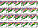
30 year old software remains undefeated arc continues.Let the old-school nowcasting begin. I bet there's a whole bunch of folks who have never seen this old blast-from-the-past piece of software. Still runs, though, and still lets me plot what's happening better than just about anything. The folks at Oklahoma Mesonet built this back I believe in the Windows98 era, if I recall correctly.
https://okfirst.mesonet.org/train/WeatherScopeHelpPC/Extra/Main.html
View attachment 50234
30 year old software remains undefeated arc continues.
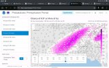
Additionally, FFC just released a multimedia web summary for this event. Combination of ice and wind are driving FFC's greatest concern.
Well obviously that would be a problem. The WAA would be shunted further SE I would think. If that’s the case TN is in more trouble with the ice than N AlabamaSo.. I’m seeing on wx twitter (X) that the storm is initializing further S than modeled.. How would that affect N Alabama? I rolled the dice and assumed we’d escape the ice.. Didn’t buy a lot of supplies.