• Welcome to TalkWeather!
    We see you lurking around TalkWeather! Take the extra step and join us today to view attachments, see less ads and maybe even join the discussion.
    CLICK TO JOIN TALKWEATHER

January 23-25th Winter Wx

Who do you think wins out in the state of TN? I’m just curious your thoughts?
I have long ago given up the idea of my making predictions, but a cold shift favors whatever was previously north of you happening over you. :D

Seriously though, what part of TN? I expect you'll see some icing.
 
Last edited:
We're now going into nowcasting mode but best areas with potneital for 6 in+ of snow look to be in the Lexington area @slenker, stay safe! and areas of the NE with high potential and even your area @Kds86z so please do watch out and stay safe!

In terms of freezing rain potential, i found another brilliant site that might message the NBM a bit better then the other website i used. More simpler to use too. Trends continue to suggest this will be problematic...

i also have a unnecessary number of tabs LOL

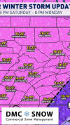
This is the last time I'll post any graphic since we're nowcasting pretty much. But my last words in general, take this very seriously, snow/freezing rain. They can be very problematic hazards and a lot don't underestimate it.
Thanks. Stay tuned for pics.
 
I have long ago given up the idea of my making predictions, but a cold shift favors whatever was previously north of you happening over you. :D

Seriously though, what part of TN? I expect you'll see some icing.
Well that’s just it, it had rain all the way to the KY line. Now it’s suppressed under the TN line. They really didn’t have a freezing rain QPF for our area to the north so I can answer that question based off your comment
 
Really starting to crank up now. Check the southern dip in the freeze lines after saturation. I always find that cool.
1769203764402.png
 
HRRR has winter precipitation tomorrow morning spread across north Alabama and into nw Georgia
Wow, already within the 18hr, and increasing each run. Good catch. Hello, surprise early party guest.
1769204640678.png
 
Yep. Like I told one of my meteorology friends this morning, the short range models aren't handling the ice totals well yet because they are just getting in range and will be higher on totals. The 18z HRRR shows my fear
 
What’s the chances for up to 2 feet of snow in Central Virginia? Can someone break it down?
 
Back
Top