Equus
Member
New runs not backin' down
Follow along with the video below to see how to install our site as a web app on your home screen.
Note: This feature may not be available in some browsers.
Thanks. That is crazy looking. I really wish my. daughter and her girls were back home in Round Rock. Mom, brother, and cousins are in Smithville, Fulton and Tupelo MS and Holly Pond, AL.
I hate days like this,
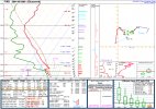
The 18z NAM 3km shows discrete cells forming between 15z - 18z as the line approaches AL. Discrete cells continue in front of the main qlcs as it progresses across AL, even into GA. View attachment 2310
View attachment 2311
View attachment 2312
Of course this little plot is disturbing......
View attachment 2313


I knew there was an event in the past that I think is in someways similar- I remember this day well, the squall line formed back in Mississippi during the morning show and it came through Bham around lunchtime.
https://www.weather.gov/bmx/event_02162001
View attachment 2316
View attachment 2317

 www.wtvy.com

I do too! I'm about 20 minutes from Holly Pond. If it makes you feel any better, tornadoes in Cullman County typically don't go over that area. (With the exception of 4/27/11, but that was an extraordinary day.) Tornadoes in this area typically start or come from the Smith Lake area and go through the city of Cullman. Not all, but that is a common path. Although lately, there have been more and more coming close to my area in Hanceville. I'm really, really, really not looking forward to Saturday.

Yeah this is looking very problematic. All of the CAMs are coming in with more of a discrete/semi-discrete mode tomorrow with strong UH tracks. Also, a few of them are indicating downscale growth of the QLCS later on in LA/AR with the potential for more supercells.


I live near fulton, and work in monroe county in EMS.Thanks. That is crazy looking. I really wish my. daughter and her girls were back home in Round Rock. Mom, brother, and cousins are in Smithville, Fulton and Tupelo MS and Holly Pond, AL.
I hate days like this,

The 3km NAM may be wrong, it wouldn't surprise me because I hate it, but that is actually very weak helicity tracks and those discrete cells are nothing more than garbage convection and could be elevated as depicted in that run.
Like I said, not at all saying it's correct, but if it is the tornado threat is lessened by quite a bit.