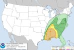
• Welcome to TalkWeather!
    We see you lurking around TalkWeather! Take the extra step and join us today to view attachments, see less ads and maybe even join the discussion.
    CLICK TO JOIN TALKWEATHER
  • April 2024 Weather Video of the Month
    Post your nominations now!
Logo 468x120

Severe WX January 10-12, 2020 Severe Weather Forecast Thread

ARCC

Member
Messages
503
Reaction score
309
Location
Coosa county
Also, if convection has a UH streak, it’s not junk convection. That’s literally the opposite of what junk convection is.

Which is correct, but since none of the prefrontal convection(except for the lone supercell that comes off the gulf) has any along with sounding profiles ahead of the line; it's safe to assume that all the prefrontal convection is junk convection.

floop-hrwarw-2020011012-refcmp-uh001h-us-se.gif
 
Messages
2,860
Reaction score
4,670
Location
Madison, WI
HRRR seems to be zeroing in on an area near/NE of the DFW metro to the Red River for a discrete cell or two with a pronounced UH streak this afternoon. That jives with that STP plot. Problematic.
 

JayF

Technical Administrator
Staff member
Administrator
Moderator
Sustaining Member
Technical Admin
Messages
1,626
Reaction score
883
Location
Hartselle, al
HAM Callsign
KB4JCS
First Tornado warning issued for the day was just issued in Hughes, Oklahoma. Here we go.
 
Messages
2,860
Reaction score
4,670
Location
Madison, WI
Which is correct, but since none of the prefrontal convection(except for the lone supercell that comes off the gulf) has any along with sounding profiles ahead of the line; it's safe to assume that all the prefrontal convection is junk convection.

floop-hrwarw-2020011012-refcmp-uh001h-us-se.gif

Weren't there a couple events in the cool season a few years ago, Feb. 2016 perhaps, where supercells with tornadic waterspouts came off the Gulf and produced EF3 damage in/near the Pensacola metro?
 

ARCC

Member
Messages
503
Reaction score
309
Location
Coosa county
Weren't there a couple events in the cool season a few years ago, Feb. 2016 perhaps, where supercells with tornadic waterspouts came off the Gulf and produced EF3 damage in/near the Pensacola metro?

Along the gulf is always very favored for tornadoes in these setups. Wouldnt surprise mad if this general area deals with the lone supercell that causes major problems.
 

Kory

Member
Messages
4,928
Reaction score
2,119
Location
Tuscaloosa, Alabama
Weren't there a couple events in the cool season a few years ago, Feb. 2016 perhaps, where supercells with tornadic waterspouts came off the Gulf and produced EF3 damage in/near the Pensacola metro?
Synoptically 2/23/16 and this event are worlds apart. But yes, 2/23 had multiple strong tornadoes on the Gulf Coast.
 

Equus

Member
Messages
3,322
Reaction score
3,473
Location
Jasper, AL
Special Affiliations
  1. SKYWARN® Volunteer
NAM still throwing out >500 0-1km SRH over NW AL as the line approaches... the wind fields in this system are absolutely ridiculous. Have honestly never seen so many smoothly curved 0-2km or so hodos (despite the massive VBV over TX) over such a huge swath.
 

Kory

Member
Messages
4,928
Reaction score
2,119
Location
Tuscaloosa, Alabama
NAM still throwing out >500 0-1km SRH over NW AL as the line approaches... the wind fields in this system are absolutely ridiculous. Have honestly never seen so many smoothly curved 0-2km or so hodos (despite the massive VBV over TX) over such a huge swath.
Yeah those low level winds are so strong they’ll mix out any stable layer/inversion near the surface.
 
Messages
151
Reaction score
208
Location
Flowery Branch, GA
HAM Callsign
KM4JKH
Special Affiliations
  1. SKYWARN® Volunteer
Anyone heard from Fred Gossage? Always love to get his thoughts on severe threats. Somebody put out the bat signal to Fred!

"Bat Signal"..... LOL.... love it.

You brought back memories.... the most intense and memorable post I ever remember here on talk weather was Fred's post just prior to 4/27. Still remember how I physically felt when I read his post.
 

Richardjacks

Member
Meteorologist
Messages
1,161
Reaction score
1,331
Location
Atop Red Mountain Birmingham, Al
"Bat Signal"..... LOL.... love it.

You brought back memories.... the most intense and memorable post I ever remember here on talk weather was Fred's post just prior to 4/27. Still remember how I physically felt when I read his post.
Based on a brief facebook interaction this morning, he thinks the line could have strong tornadoes within.
 

WesL

"Bill, I'm talkin' imminent rueage"
Staff member
Administrator
Moderator
Sustaining Member
Messages
3,384
Reaction score
2,695
Location
Fayetteville, AR
Special Affiliations
  1. SKYWARN® Volunteer
Morning everyone.

With this multi-day threat starting to kick off we have decided to have two threads for this event. This thread will be reserved for forecast for the entirety of the event. There is now another thread that should be used to capture real-time storm information (aka Nowcasting) and storm reports. The intent is to ensure that the forecast information for the system tomorrow is easy to find and reference for those who are under the gun tomorrow. The moderating team will be working to help move posts over from this point forward but we appreciate you helping us keep this organized.

As always we appreciate you being a part of TalkWeather and hope that each of you remain safe over the next few days.

Wes
 

JayF

Technical Administrator
Staff member
Administrator
Moderator
Sustaining Member
Technical Admin
Messages
1,626
Reaction score
883
Location
Hartselle, al
HAM Callsign
KB4JCS
A major change to the day 2 outlook. Mississippi and Alabama almost in their entirety are covered in the enhanced risk area.
 

Attachments

  • New day 2 Outlook.jpg
    New day 2 Outlook.jpg
    71.9 KB · Views: 0
Back
Top