- Thread starter
- #281
akt1985
Member
Alabama Weather Network is now live with wall to wall coverage through the duration of Isaias across the state.
Follow along with the video below to see how to install our site as a web app on your home screen.
Note: This feature may not be available in some browsers.
Beautiful. I would bet it will be interesting tomorrow too, "red sky at morning..."This was in Brushy Pond (SW Cullman County). Pretty incredible.
View attachment 55246


Knocking on the door of a low end cat 4 nowRecon just had pressure recording of 951...


Spicy storms incoming, big bend area.wx_guy is back, that's nice!
There is a nasty waterspout off shore right now.
I know yesterday, I said that I didn't think that tonight would be the main tor threat but with admittedly stronger LL response as a result of surprise over performing intensity, there are problems with the outer bands svr wx wise.
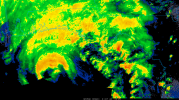
I'd leave open the possibility that was just a pulse. No shortage of moisture blowing up to the west again.the precip is really collapsing on the west side of the storm.
i suspect mobile county gets less than 1" of rain from 3pm to the end of the event.
also, with the storm east of where it was projected a day or two ago, this dramatically reduces the coastal flooding threat along the alabama gulf coast.
navarre over to destin looks to take the brunt of it.

 weather.cod.edu