For later:
Santa Rosa Island cams:
Perdido Key
Destin
Santa Rosa Island cams:
Perdido Key
Destin
Follow along with the video below to see how to install our site as a web app on your home screen.
Note: This feature may not be available in some browsers.


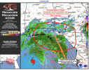
Where in south central alabama? Hopefully not Dallas County.Looking at hrrr its got a corridor of like 80mph gusts into south central alabma. Im guessing its the sting jet? Or could just be elevated gusts from the hurricane
Destin

Camera: Destin Harbor, East Pass and Crab Island (aerial)
Host: EarthCam
Link: link (https://www.earthcam.com/usa/florida/destin/)
────────────────────────────────────────
Camera: Gulf, East Pass and Harbor
Host: Jetty East
Link: link (https://www.jettyeast.com/webcam/)
────────────────────────────────────────
Camera: HarborWalk Village: Crab Island, marina, village
Host: Emerald Grande
Link: link (https://www.emeraldgrande.com/harborwalk-village/harbor-cams/)
────────────────────────────────────────
Camera: Mid-Bay Bridge (Destin to Niceville)
Host: Legendary Marina
Link: link (https://legendarymarina.com/live-cam/)
────────────────────────────────────────
Camera: Pompano Joe's beach cam
Host: Pompano Joe's
Link: link (https://www.pompano-joes.com/beachcam)
────────────────────────────────────────
Camera: Crab Island cams
Host: Original Crab Island
Link: link (https://originalcrabisland.com/crab-island-destin-live-cam/)
────────────────────────────────────────
Camera: Crab Island, Pelican Beach, The Alice marina and pier
Host: La Dolce Vita
Link: link (https://ldvbeach.com/ldv/webcams)
────────────────────────────────────────
Camera: Resorts of Pelican Beach
Host: LiveBeaches
Link: link (https://www.livebeaches.com/webcams/resorts-of-pelican-beach-live-cam/)
────────────────────────────────────────
Camera: Destin beach cam and surf report
Host: The Surfer's View
Link: link (https://thesurfersview.com/live-cams/florida/destin-beach-cam-and-surf-report/)
────────────────────────────────────────
Camera: Hub: Henderson Park Inn, Inlet Reef, SunDestin, Gulfgate, Sterling Sands and more
Host: LiveBeaches
Link: link (https://www.livebeaches.com/city/destin-fl/)

Just east of Destin (Miramar Beach and Sandestin): Sandestin Beach (EarthCam) (https://www.earthcam.com/usa/florida/destin/sandestinbeach/), Hilton Sandestin (https://www.hiltonsandestinbeach.com/destin-webcam), Ocean Reef Resorts (https://www.oceanreefresorts.com/beachcam/destin-florida-beach-cam/).

Fort Walton Beach and Okaloosa Island

- Okaloosa Island Pier underwater cam (https://www.youtube.com/@DestinFortWaltonBeach/live): run by the county tourism office (Destin-Fort Walton Beach) on YouTube. I couldn't confirm it was broadcasting.
- The Breakers: beach and the pier (https://www.breakersfwb.com/live-beach-cam/)
- Holiday Inn Resort beach cam (https://holidayinnresortfortwaltonbeach.com/beach-cam/)
- Wyndham Garden Okaloosa Island (https://www.webcamtaxi.com/en/usa/florida/wyndhan-garden-view.html)
- Okaloosa Island Pier (ShorelineScout) (https://shorelinescout.com/florida/webcams/okaloosa-island-pier/)

Navarre Beach

- Navarre Beach Pier Live, 24/7 on YouTube (https://www.youtube.com/@NavarreBeachPierLive): I confirmed it was live when I checked.
- Navarre Beach Life HD zoom cam (https://www.navarrebeachlife.com/live-hd-1080-zoom-cam/)
- Hub: pier, surf, underwater and RV park cams (https://www.livebeaches.com/city/navarre-beach-fl/)

Pensacola Beach and Pensacola

- Santa Rosa Island Authority Casino Beach cams (official) (https://visitpensacolabeach.com/web-cams/): its page says they're offline during the pier renovation.
- Visit Pensacola webcams (https://www.visitpensacola.com/webcams/): east, west and south beach views, Quietwater Beach and the Perdido Key Entertainer cam. This page lists them as live, which conflicts with the official page's notice.
- Hub: Fort Pickens (National Park Service), Hilton, Peg Leg Pete's and more (https://www.livebeaches.com/city/pensacola-beach-fl/)
- Pensacola Beach Pier (ShorelineScout) (https://shorelinescout.com/florida/webcams/pensacola-beach-gulf-pier/)
- Pensacola Bay Bridge traffic cam (WeatherBug) (https://www.weatherbug.com/traffic-cam/gulf-islands-natl-seashore-fl-32563/463861) and the official Florida 511 (https://fl511.com/) cameras.

Perdido Key

- Mirabella Beach (https://www.skylinewebcams.com/en/webcam/united-states/florida/perdido-key/mirabella-beach.html)
- La Riva Resort (https://30a.com/la-riva-webcam-perdido-key-fl/)
- Perdido Key Entertainer (Intracoastal) (https://www.visitpensacola.com/webcams/perdido-key-entertainer-webcam/)
- Hub: Vista Del Mar, Eden and more (https://www.livebeaches.com/city/perdido-key-fl/)

Orange Beach

- Perdido Pass and Alabama Point (https://webcamexpo.com/perdido-pass-orange-beach-webcam/)
- Turquoise Place (https://www.livebeaches.com/webcams/turquoise-place-beach-resort-live-cam/)
- Orange Beach cam (https://www.skylinewebcams.com/en/webcam/united-states/alabama/orange-beach/beach.html) and panorama (https://www.skylinewebcams.com/en/webcam/united-states/alabama/orange-beach/panorama.html) (SkylineWebcams)
- Phoenix X, IX, Gulf Towers, East II, plus Gulf Shores cams (Brett/Robinson) (https://www.brett-robinson.com/webcams/)
- The Surfer's View (https://thesurfersview.com/live-cams/alabama/orange-beach-cam-surf-report/)
- FOX10 Weather Cam (https://www.livebeaches.com/webcams/fox-10-weather-orange-beach/)
- Hub: Enclave, Perdido Beach Blvd, Zeke's Landing Marina (https://www.livebeaches.com/city/orange-beach-al/)
- Wolf Bay Osprey Cam (City of Orange Beach, official) (https://www.orangebeachal.gov/240/Wolf-Bay-Osprey-Cam) is a wildlife cam, not a beach view.
- ALGO Traffic (official ALDOT cameras) (https://algotraffic.com/Cameras) for Orange Beach and Gulf Shores roads.

Gulf Shores

- Gulf Shores beach cam (https://www.skylinewebcams.com/en/webcam/united-states/alabama/gulf-shores/gulf-shores.html) (SkylineWebcams)
- Sea-N-Suds, on the pier at Boardwalk Condominiums (https://bamabeachcams.com/sea-n-suds.aspx)
- The Beach Club Resort and Spa (https://www.livebeaches.com/webcams/the-beach-club-resort-spa-live-cam/)
- Gulf Shores beach cam, HD (HDBeachCams) (https://hdbeachcams.com/beach-webcams/gulf-shores-beach-cam/)
- Bella Terra rentals cams (https://www.bellaterrarentals.com/beach-cams.htm)
- Hub: Phoenix, Pink Pony Pub, Kiva Dunes and more (https://www.livebeaches.com/city/gulf-shores-al/)West side of bamaWhere in south central alabama? Hopefully not Dallas County.
My goodness! That's bad!Wow! Read this from the discussion:
Strong deep-layer shear has definitely increased as forecast, with
various analyses now showing 30-40 kt out of the southwest.
However, the shear vector is nearly aligned with the storm's
motion, which limits its adverse effects, and upper-level
divergence is also increasing over the hurricane. This setup has
likely allowed the hurricane to intensify this morning, and the
hurricane regional models (HAFS-A, HAFS-B, and HWRF), as well as
the statistical-dynamical models (SHIPS and LGEM), all suggest that
Isaias could maintain major hurricane intensity up until its
landfall this evening. Therefore, the NHC official forecast depicts
Isaias with 100-kt winds just offshore the western Florida
Panhandle this evening. Weakening will occur after landfall, but
sustained hurricane-force winds will likely occur near and along
Isaias's track up to 100 miles inland from the coast into southern
Alabama, and gusts to hurricane force could extend even farther
north into central Alabama. Isaias is likely to lose its tropical
characteristics by 36 hours when it is over northern Alabama.
Aircraft fixes indicate that Isaias has drifted a bit east of the
previous forecast track. NHC's track forecast leans on the eastern
side of the guidance envelope, closest to the latest HCCA and GDMI
guidance, and implies a potential landfall along the extreme
western Florida Panhandle coast this evening. After moving inland,
the center of Isaias is expected to continue northward through
Alabama, before turning northeastward over the Tennessee and Ohio
Valleys (as a post-tropical remnant low) on Sunday.
Upshot: No longer forecast to weaken before landfall!! HUGE NEWS!! And big news for inland Alabama everyone!

As a weather watcher, I'm glad I caught the potential, but as a human and Alabamian, sometimes you just don't want to be right. Sigh.The hot TCHP pool has me worried, TBH. That is deep fuel, and a lot of it. Deep ocean heat content is the reason storms are overperforming, IMO, and this will be the deepest it has passed over. Fingers crossed that shear wins. I am really hoping it does, because if the upper level winds just vent it instead of tearing it apart, we may be in real trouble.