Logo 468x120

Iceland's Fagradalsfjall Fires

bjdeming

Member
Sustaining Member
Messages
1,623
Reaction score
1,334
Location
Corvallis, Oregon
Everyone here is familiar with weather emergency management. For comparison, here (autotranslated) is how they're doing it in probably the only place on Earth where volcanic activity is as expected as severe weather.

On the Thorbjorn-2 cam it looked like work has resumed at least one of the barriers north of town.

(Edit: Fixed the link.)
 
Last edited:

bjdeming

Member
Sustaining Member
Messages
1,623
Reaction score
1,334
Location
Corvallis, Oregon
Volcanologists have a strange notion of "safe distance," bless 'em.


bjdeming

Member
Sustaining Member
Messages
1,623
Reaction score
1,334
Location
Corvallis, Oregon
Another tweet, if no one minds (since I can't say anything intelligent about volcanology as so many TalkWeather folks can about interesting weather).

This is from a professor of volcanology at the University of Manchester:


bjdeming

Member
Sustaining Member
Messages
1,623
Reaction score
1,334
Location
Corvallis, Oregon
Everyone here is familiar with weather emergency management. For comparison, here (autotranslated) is how they're doing it in probably the only place on Earth where volcanic activity is as expected as severe weather.

On the Thorbjorn-2 cam it looked like work has resumed at least one of the barriers north of town.

(Edit: Fixed the link.)
Just to follow up, they did decide to open Grindavik and elsewhere again, but per RUV (autotranslated) life on an active volcano is not fun (also, the next time a tornado siren sounds, try thinking of it as a 'warning whistle' :) ):

Still dangerous to be in the area

The police would like to convey the following to those who intend to enter Grindavík:
There are closure posts at Bláalónsveg, Nesveg and Suðurstrandarveg. It is also not possible to drive Grindavíkurveg into Grindavíkur, as lava flowed over the highway during the volcanic eruption last January 14.
To draw people's attention to the surrounding dangers, three warning whistles have been installed in Grindavík. There is also one of these at the Bláa lónid and another at HS energy in Svartsengi. Yesterday they were used for evacuation with good results.

Police instructions to those entering Grindavík​


  • Residents and employees enter the town at their own risk. Each person must be responsible for their own actions or inactions. The police chief makes it clear that Grindavík is not a place for children or children to play. There are no functioning schools and the infrastructure is in a state of disrepair. The police chief does not recommend that people stay in the town.
  • There are many cracks in the ground in and around the town and cracks can open without warning. The danger is estimated to be considerable from ground fall into cracks and crack movements. Mitigation measures are and have been ongoing, which include, among other things, mapping, ground survey, geodetic measurements and visual inspection. Then cracks have been fenced off.
  • Open areas in and around Grindavík have not been examined separately. People should stay on the streets of the town and avoid going out into plots and other open areas.
  • Grindavík is closed to everyone other than emergency responders, residents of the town, employees of the town's companies and those who need to help residents. Media personnel are authorized to enter the town in the same way as residents and company employees.
  • In the operational area of the Blue Lagoon, Northern Light Inn and HS energy, there is considered a very high risk of lava flow. For a while, access routes were narrowed when lava flowed over Grindavíkurveg and closed the way to the Blue Lagoon, Northern Light Inn and HS energy. A road was laid over the newly flowed lava and the approach via Grindavíkurveg was reopened.
There have been news reports lately of tourists seen in Grindavik, photographing ruins (which Grindvikings say they don't do out of consideration for someone who has lost so much); last winter, an RUV reporter was caught going into an empty house, too -- for power, I suppose).
 

bjdeming

Member
Sustaining Member
Messages
1,623
Reaction score
1,334
Location
Corvallis, Oregon
Geology-wise, the good news (autotranslated) is that the crust above the sill did subside, probably buying everyone at least a day or two of time while the sill refills.

In that article, Benedikt is quoted as saying he thinks a new site will open for (hopefully) just another dike intrusion soon, though it's possible yesterday's dike might work, too.

The reporter didn't pick up on it, but I would have asked about possible hazards of multiple dikes forming over a geologically short span of time (months). But this ares is so complicated -- who knows for sure?

Why didn't it erupt?


"There is something in the system that prevented this from reaching its goal. Why that is, is perhaps difficult to say. It is possible that the magma corridor is more reluctant to accept more magma. There's one possible explanation, but I wouldn't say that right away. We'll just have to see how this develops. I think it is very likely that something will happen again very soon," answers Benedikt.


"At least we're not going to wait three weeks for something to happen," he adds.


Data indicates that yesterday's magma flow has stopped...

Data indicates that yesterday's magma flow stopped at Hagafell. Map/mbl.is


bjdeming

Member
Sustaining Member
Messages
1,623
Reaction score
1,334
Location
Corvallis, Oregon
No changes yet, although the current geoscientist note (autotranslated, time dependent) is more succinct than usual; the linked main article thus far hasn't been updated since eruption day.

Magnus Tumi drew some parallels with Krafla during an interview (autotranslated) today that also reflects the new reality Icelanders are facing in the foreseeable future. I hope they also get "touristy" eruptions, like those thus far in Fagradalsfjall, too.

Others have compared this to the Krafla Fires, too.

PS: Visir has a nice image of the ultra-damaging Feb. 8 flow in relation to the power plant here (autotranslated):

Probably makes headlines this week​

Lillý Valgerður Pétursdóttir writes March 4, 2024 12:16 p.m
Land continues to rise under Svartsengi and it is likely to make headlines this week.
Land continues to rise under Svartsengi and it is likely to make headlines this week.INDICATOR/RAX

According to Benedikts Ófeigsson, a geophysicist at the Icelandic Meteorological Office, it is likely to make headlines again in Reykjanes this week. The magma chamber under Svartsengi continues to fill, but tomorrow the situation will probably be the same as before the last magma flow.​
 
Last edited:

bjdeming

Member
Sustaining Member
Messages
1,623
Reaction score
1,334
Location
Corvallis, Oregon
New IMO update:

Increased chance of eruption​


Magma volume under Svartsengi continues to increase​


4.3.2024

Updated March 4 at 1:30 p.m


Probable sequence of events for the next few days:


  • The volume of magma under Svartsengi continues to increase, which could result in a new magma flow and even an eruption
  • An eruption could start at very short notice, even less than 30 minutes
  • An eruption is most likely to occur in the area between Stóra-Skógfell and Hagafell

Model calculations show that the amount of magma that flowed on Saturday from Svartsengi into the Sundhnúks crater series was about 1.3 million cubic meters.


Previously, it had been calculated that around half a million cubic meters of magma accumulates under Svartsengi in a 24-hour period. All things being equal, the total amount of magma under Svartsengi will be around 9 million cubic meters by the end of the day tomorrow, Tuesday.


In previous events, magma has flowed when the total amount of magma accumulated under Svartsengi is between 8 and 13 million cubic meters. Therefore, there is an increased probability of a new magma flow and eruption once that amount has been reached.


However, it can be pointed out that after repeated eruptions in Fagradalsfjall, there were examples of magma creeping up to the surface without much seismic activity. It has to be assumed that it could be the development with the activity on the Sundhnúks crater series.

<Layperson speculation> Also, regarding Krafla and its fires in the 1970s and 1980s, it might be that volcanologists use it as a recent example to help everyone adjust to the idea of repeated eruptions in the country's most populated section for the first time in centuries.

But Krafla is a different type of Icelandic volcano -- the sort that has a center with radiating swarms of fissures, as do such volcanoes as Bardarbunga and Grimsvotn (the Laki Fires of 1783 were in the Grimsvotn system AFAIK).

Being in eastern Iceland, Krafla has a different magma chemistry, too, with more silica in it that sometines makes it go boom big time.

On the Peninsula, it's just fissure swarms, in what had always looked like more or less separate systems, all oriented SW-NE because of the general tectonics here, until it was discovered that Fagradalsfjall and Svartsengi lavas have similar 2021-2024 petrology that is unlike the Sundhnukur crater row lavas -- where magma is presently active. This really shouldn't be.

There was a deep magma chamber found under Krafla during its fires, and at first this was suggested as the case on the Peninsula, too, but AFAIK none has been found and it has been a while since I saw news stories where geoscientists speculated on that.

They might be short of a conceptual model consensus that can explain the data for these fires. I think that's why that one group took a risk and went out there the other day to collect gas samples -- indirect and other gas data might tell them more about what is going on here underground in this part of the Mid-Atlantic Ridge in between the two continental plates.

They really need to know as much as possible.

In this sense, it's not like the Krafla Fires much. The good news is that there is less silica in magma here and the only explosions we might see will be when water and molten rock meet -- none of that eastern Iceland big-gun ignimbrite stuff.

Enough already. Just a glimpse of how complicated, even to a layperson skimming the academic surface in hopes of contributing to a broader general understanding, Iceland's geology is.</Layperson speculation>
 

bjdeming

Member
Sustaining Member
Messages
1,623
Reaction score
1,334
Location
Corvallis, Oregon
Only in Iceland (from current mbl.is page)...

screenshot_20240304-072959_firefox.jpg
 

bjdeming

Member
Sustaining Member
Messages
1,623
Reaction score
1,334
Location
Corvallis, Oregon
IMO just released a new update (autotranslated) repeating some of yesterday's points but adding that seismic activity has been more frequent in Fagradalsfjall and also that weather conditions will interfere with their monitoring for a while.

This screenshot of the current unreviewed quake graphic shows the general location of Fagradalsfjall relative to Grindavik:

screenshot_20240305-033818_firefox.jpg


It's the line on the left and the one on the right.

The pyramid-shaped object in this mbl.is live cam of Reykjavik is the "Keilir" mentioned in the quake graphic -- and the general site of the Litli-Hrurtur eruption about a year ago (i.e., Reykjavik won't be threatened if a similar eruption starts there):


Apparently they don't have a live Litli-Hrutur cam up at the moment.
 
Last edited:

bjdeming

Member
Sustaining Member
Messages
1,623
Reaction score
1,334
Location
Corvallis, Oregon
From my blog this morning:

IMO spokespeople today focus on the November 10th dike, which has been very quiet, and the agency’s March 5 update is still in force, even though seismicity closer to Grindavik has gotten interesting, with a 2-pointer east of town on the 4th (note that these screenshots are from the unreviewed list):


A 2-pointer west of town on the 5th:


And a 3-pointer this morning that an IMO source is quoted as saying (autotranslated) was unrelated to the Grindavik system:


With constant magma flow into the sill and apparently no escape route to release pressure, this series of really just barely moderate-intensity earthquakes is not surprising, but why are they in this location, on either side of a rift zone that runs through Grindavik, I wonder.


We will just have to wait and see...

Also this (Twitter translation):

"On the left: Location of earthquakes 100 days before the formation of the magma tunnel on 10 November, which reached, among other things, under Grindavík.Right: Location of an earthquake 100 days after its formation.

"The latest tremors appear to be closer to the pre-November 10 pattern. The magma tunnel has become unrecognizable.But it can change like so many other things in life."


bjdeming

Member
Sustaining Member
Messages
1,623
Reaction score
1,334
Location
Corvallis, Oregon
Another post:

There was a 2-pointer a couple of hours ago in the Keilir section near Krysuvik:


Keilir is the site of the last Fagradalsfjall eruption, a year ago (Litli Hrutur).


Also, mbl.is has turned their Keilir cam on (some six hours before the 2-pointer), though there is no indication that anything is likely to break soon — there or elsewhere.


However, RUV notes (autotranslated) that it was a quiet night seismically.


When the Fagradalsfjall “touristy” eruptions were active, things did quiet down just before an eruption.


So everyone is watching the situation a little more closely today, for sure.

Here is that cam:


We're looking at the same pyramid as in the Reykjavik cam earlier in this thread but from the other side.

Those lights in the background are in Reykjavik.

The Litli Hrutur eruption started almost at Keilir's feet. It was an impressive setting.

Heck, might as well include views from the Svartsengi sector, too, just in case -- RUV's mosaic, though they, mbl.is, and Visir all have more cams down there live on YouTube, too:


bjdeming

Member
Sustaining Member
Messages
1,623
Reaction score
1,334
Location
Corvallis, Oregon
I think the Litli Hrutur cam is still live -- from the other side of Keilir, it looks as though Reykjavik is having some intense storming.

As IMO says in today's update (autotranslated):

...weather for the next 24 hours is likely to affect the Norwegian Meteorological Agency's monitoring system. For the next 24 hours, there will be a south-easterly trend or a light wind with rain and limited visibility, especially in the mountains. In the morning, the precipitation decreases, but tomorrow and the following days there is a chance of isolated showers and it is likely that visibility will be low while this is over. Rather, the wind will decrease during the weekend, a southeasterly breeze or cold on Sunday.


Expansion continues under Svartsengi and model calculations based on GPS data from 3.-6. March shows that about 1.2 million cubic meters of magma have been added to the magma chamber these days. So, in total, more than 10 million cubic meters of magma have accumulated in the magma chamber. The situation is therefore similar as it was before the magma run on March 2...

At least they've still got borehole SV-12 down Svartsengi way (autotranslated).
 

bjdeming

Member
Sustaining Member
Messages
1,623
Reaction score
1,334
Location
Corvallis, Oregon
screenshot_20240308-135512_firefox.jpg
An M2.8 just short of a mile north of Grindavik, 1-1/2 hours ago:
 

bjdeming

Member
Sustaining Member
Messages
1,623
Reaction score
1,334
Location
Corvallis, Oregon
Also, IMO posted (autotranslated) a report on the March 2 dike intrusion:

Model calculations show that the magma tunnel that formed on March 2 was about 3 km long and reached from Stóra-Scógfell to Hagafell. The map below shows its location according to these accounts.


The magma in the tunnel lies at a depth of 1.2 km where it is shallowest and reaches a depth of about 3.9 km. According to the model calculations, about 1.3 million cubic meters of magma flowed into the Sundhnúks crater series during the March 2 magma flow. There is a much smaller amount of magma than in previous events, but model calculations show that around 10 million cubic meters (or more) flowed from Svartsengi into the Sundhnúks crater series.


Map_Kvikugangur02032024


All things considered, the magma looks for the easiest way to the surface, and it's hard to say what prevented it this time. It could be some obstruction in the flow of the magma, not enough volume or pressure to open a fissure, or even a combination of these factors.


The magma flow on March 2 behaved differently than previous magma flows during the summer and is a reason to study it further in order to further increase the understanding of the nature of magma flows in the region and to understand what the continuation of the events will be.


Looking at the history of other volcanic eruptions, it is not uncommon for a magma flow to end without an eruption. During the 10-year period in connection with the Kraflu fires 1975 - 1984, there were 20 magma flows and 9 of them ended with an eruption. The magma flows from Svartsengi to the Sundhnúks crater series have become 5 in number since November 2023, and 3 of them have ended in eruption. However, nothing can be said at this stage that the sequence of events on the Reykjanes Peninsula will behave like the upheaval in Krafla in this regard.

It's interesting that now they say that the Krafla Fires might not be a model for this ongoing event.

I can't find anything much in the online news sources I'm using, either. For the first time since November, there aren't articles with volcanologist interviews.

Don't know why but suspect that it's because Earth, thus far, isn't following its previously established (from November 2023 on) pattern -- what they say in the update, basically.

No scientists are going to speculate for the media in such circumstances, and Icelandic media have enough experience with volcanism to not try pumping the boffins or make their own speculations.

It's a serious situation.

What puzzles me is this statement in the update: "There is a much smaller amount of magma than in previous events, but model calculations show that around 10 million cubic meters (or more) flowed from Svartsengi into the Sundhnúks crater series."

A lot is lost in translation of course. Since that is almost the total sill volume, per recent IMO posts, I'm assuming they really aren't saying that the sill almost emptied out toward the crater row underground but that sill inflation continues.

Will see how things go.
 

bjdeming

Member
Sustaining Member
Messages
1,623
Reaction score
1,334
Location
Corvallis, Oregon
Still waiting; haven't seen aftershocks yet on the graphic, which is not typical of most peninsula seismicity.

Also, Visir started this cam a day ago. It's perspective is different from the others in that Grindavik is behind us; the bright lights in the center are at the power plant; the Blue Lagoon is left of that; and the lights in the background are Keflavik International (left) and Reykjavik(right):


You might see some intense bright lights moving around -- these must be workers welding pipes or otherwise working on defenses. A lava breakout would start small but it would not jump or move around much -- it would be brighter, too, and most probably a series of en echelon cracks would open along a linear axis, likely SW to NE...all very different from what the cam shows currently.

MBL.IS reported that the M2.8 was at Thornbjorn (which I think the cam is sitting on). I wonder if the mountain is trying to move, as it reportedly did in January at that eruption's onset.

You don't usually see that in a mountain. Sigh.

Thornbjorn, via mbl.is (autotranslated):

Tremor of 2.8 near Þorbjörn​


A magnitude 2.8 earthquake was recorded in Þorbjörn this evening.

A magnitude 2.8 earthquake was recorded in Þorbjörn this evening. mbl.is/Sigurður Bogi
 
Last edited:

bjdeming

Member
Sustaining Member
Messages
1,623
Reaction score
1,334
Location
Corvallis, Oregon
I thought for sure that Thorbjorn quake was heralding an eventual eruption but no -- we're still waiting.

It's not cooling down. According to Benedikt (autotranslated), Svartsengi is still inflating.

Perhaps Armann is on the right track -- he has reiterated this point in more recent interviews but this is succinct and in English (though this January article is quoting Thorvaldur):

Ármann Höskuldsson, a professor of volcanology, has often but not always talked about the possibility of Eldvörp becoming the next eruption site. Þórðarson is asked if he can see that happening.


Thinks the eruption will not be a long one

Article on Iceland Monitor


Thinks the eruption will not be a long one


“It could happen. If it closes the eruption channels at the Sundhnúkagígar crater row area and it continues to pour magma into Svartsengi, the pressure could begin to dissipate at the Eldvörp volcano, which would end in an eruption. They are farther away from Grindavík and Svartsengi, and would be a more suitable location.”
 

bjdeming

Member
Sustaining Member
Messages
1,623
Reaction score
1,334
Location
Corvallis, Oregon
This may or may not mean anything, but a low-level seismic swarm appears to be going on just north of town, i.e., the dike area:

screenshot_20240310-095610_firefox.jpg

There were three small quakes on the graphic listed between 0900 and roughly 1100 UTC this morning, too, between about 2 and 4 km deep, but I figured it could be contraction of the March 2 flow or some other nonintrusive process. Now, there seems to be energy coming from something somewhere.

There is no new update yet on the IMO site or from the online news sources I follow, but this might be worth keeping an eye on -- or not.

So little is known about the mid-ocean ridge and how it works.
 

bjdeming

Member
Sustaining Member
Messages
1,623
Reaction score
1,334
Location
Corvallis, Oregon
Still going as of about an hour ago (the last quake on the list, which only goes back six hours).

I zoomed in a bit to show both Grindavik and the Sundhnuk crater area -- it's closer to town, but there is no way for this laypersn to tell whether it's just quakes or some precursory stuff. :(

screenshot_20240310-114546_firefox.jpg
 

bjdeming

Member
Sustaining Member
Messages
1,623
Reaction score
1,334
Location
Corvallis, Oregon
And it's over with no more consequences than the recent M2.8 at Thorbjorn had. Sigh. I'd celebrate the quiet if the boffins told us the sill uplift was stopping, but no -- presumably there's at least a little more magma now than when eruptions were triggered in January and February. Odd.
 

bjdeming

Member
Sustaining Member
Messages
1,623
Reaction score
1,334
Location
Corvallis, Oregon
Per this article (autotranslated), there definitely is more magma down there and something must give sooner or later.

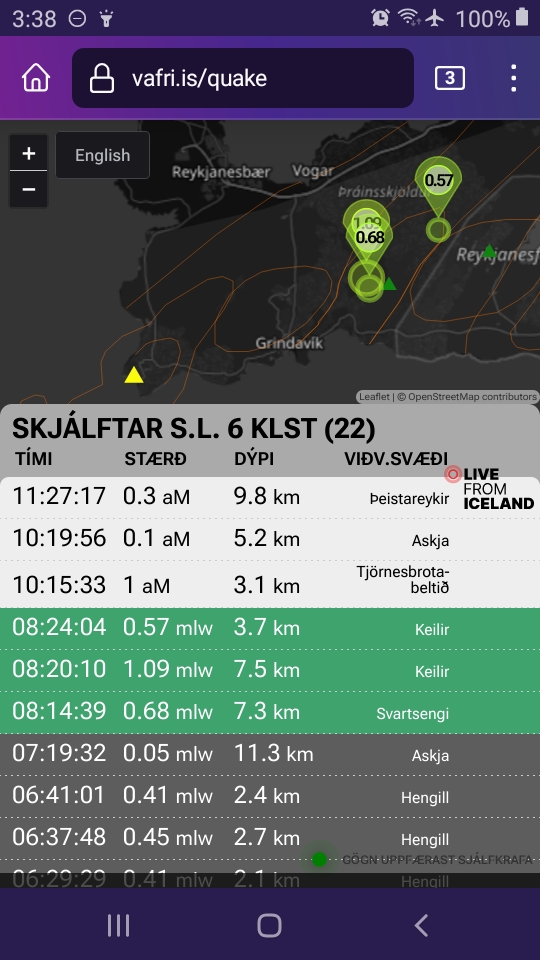
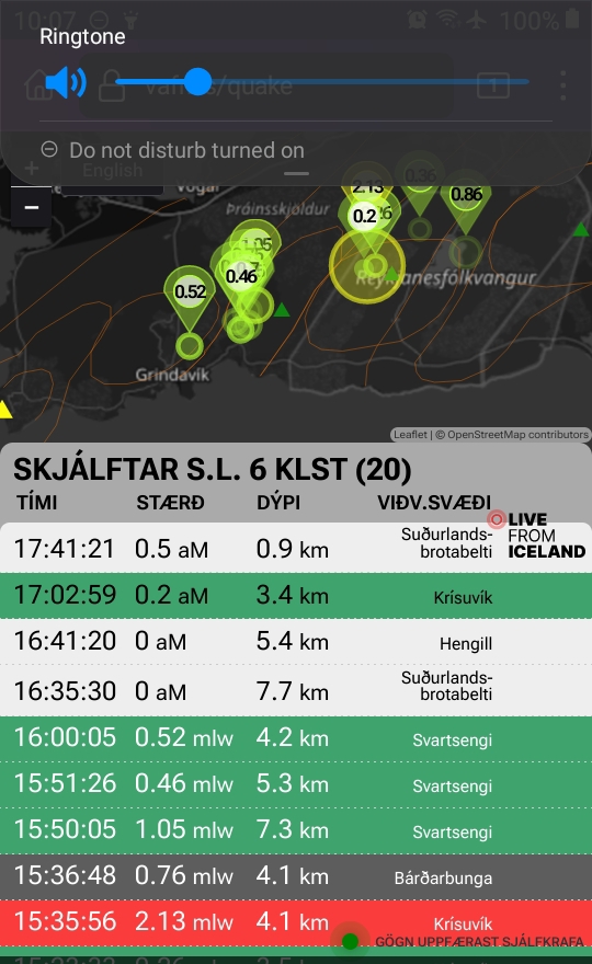
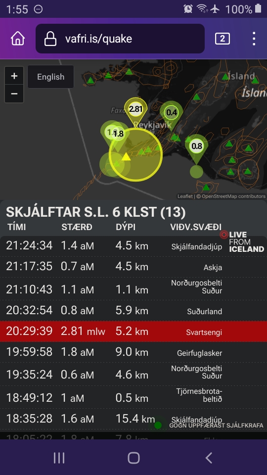
<Layperson speculation> The boffins also point out that more quakes are recorded now that the weather has cleared, but since it didn't suddenly worsen again on the cam views yesterday to again obscure the graphics data, that probably was a swarm -- one of several at the dike that volcanologists have occasionally mentioned in interviews.

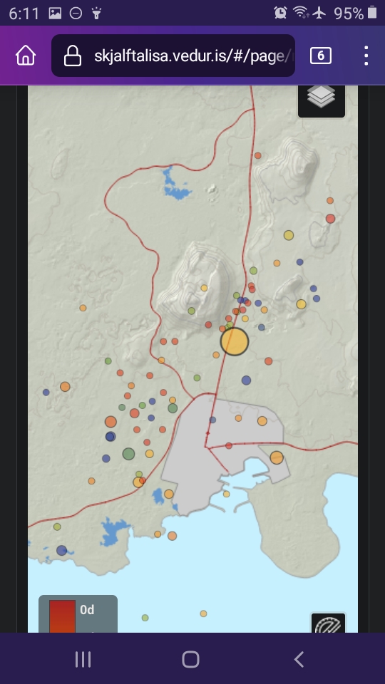
But I was wrong about energy coming in, as this IMO graphic (Icelandic) shows:

screenshot_20240311-061117_firefox.jpg


That larger circle is the Thorbjorn M2.8. Ordinarily aftershocks occur after such a larger than usual temblor -- but I don't see any here.

As mentioned in Birkir's tweet earlier in this thread, you can't see the formerly clear-cut outline of the dike on a seismicity map (even factoring in the data lost because of recent bad weather, since Birkir looked at it before those storms).

There certainly must be built-up pressure down there (and constantly growing, as inflow under Svartsengi continues per the article linked above)), but what I see in these little quakes on that IMO graphic is a failure of that pressure to find something in the crust to focus on, cut through, and escape by erupting.

In other words, although the whole peninsula surface cracked when, in the words of Volcano Cafe, "On 10 November 2023, the plate boundary snapped into a massive dike, some 18 km long. The sides of the dike rebounded, unleashing their pent-up strain from the plates pulling apart over two millennia and at the same time the ground above the dike sunk, undermined by the extension of the earth...", those cracks did not extend very far down into the ridge (on a geologic scale, of course: some are hundreds of feet or more deep -- sadly, deep enough to swallow a man).

And when you look at the magnitude of that November 10th plate-tectonic event, it really isn't surprising to see such lack of oomph in its wake (highly technical jargon there ;^) for what must be very complex geophysics and geochemistry that the boffins probably work through daily).

Not being a boffin, this layperson is free to cut loose and wildly speculate that the energy one ordinarily would expect to be released vertically when overburden is suddenly released above a magmatic system is not yet bigger than (this is totally my speculation, not backed by any authority) the horizontal energy being expended as Iceland east of the peninsula (or at least east of Lake Kleifervatn) and the Mid-Atlantic Ridge southwest of the peninsula adjust to that sudden plate separation on November 10th.

It may take a while. After all, in this part of the world continental plates usually move on average about as fast as human fingernails grow. Another factor is probably the lack of subduction zones east or west of Iceland; both North America and Eurasia have passive margins at these latitudes. And, of course, the mantle plume apparently centered under Bardarbunga is a big honkin' factor that I'm going to blithely ignore, too.</layperson speculation>

It's still a waiting game, but in a very unusual situation. Given the serious consequences for Icelanders thus far from what were really very small, brief eruptive episodes, one can only hope for more tourism-friendly activity out in the boonies again.

And wait.

And look forward to the blizzard of scientific papers that is likely to begin some six months to a year from now.
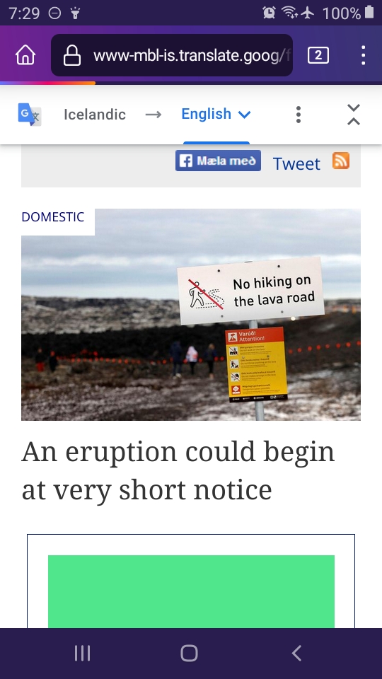
Meanwhile, in Iceland (autotranslated)...
 
Last edited:
Back
Top