Iceland's Fagradalsfjall Fires

bjdeming

Member
Sustaining Member
Messages
1,623
Reaction score
1,334
Location
Corvallis, Oregon
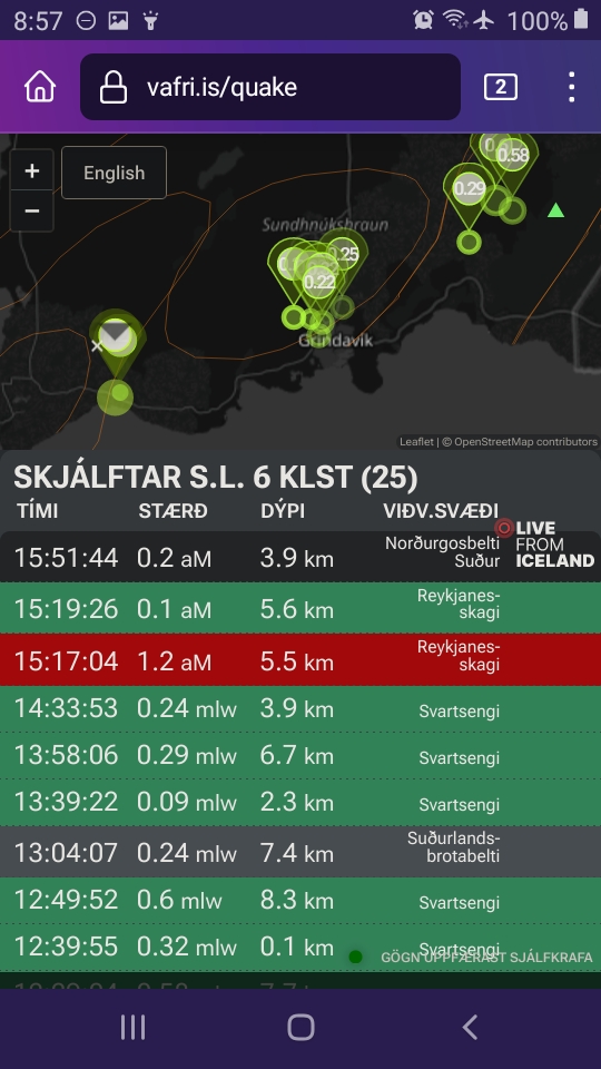
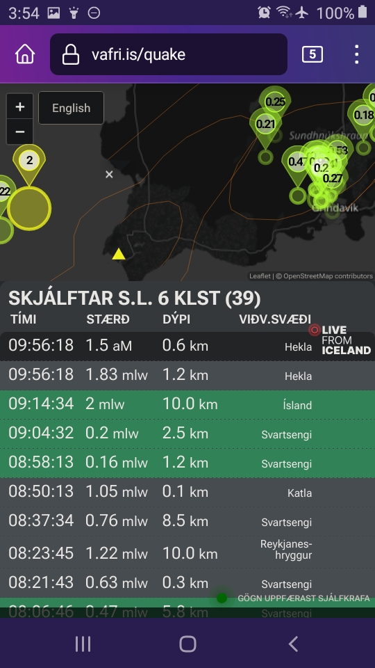
Well this interesting -- a swarm of mild but stronger than usual quakes in the Eldey system and a 1-pointer -- west of Grindavik.

This zoom shows you where things are relative to Grindavik (almost all of the Eldey system is underwater):


<Layperson speculation> I don't know what it means, but IMO did note in their update today that over 13 million cubic meters of magma is under Svartsengi now and inflation continues.

That is way more than what triggered the last two eruptions, so magmatic pressure can't be working alone here.

I wonder if that "holding force(s)" might be weakest west of Svartsengi (Eldvorp and Eldey, basically, since it's affecting the southern part of this region).

I don't see Eldvorp in the Catalogue of Icelandic Volcanoes online, although volcanologist Armann and Dr. Wikipedia talk about it. So I'm not going to speculate about that at all.

Those eastward-centered quakes in the Eldey swarm shown might be interesting, if we could see them relative to the November 10th dike.

I haven't seen any graphics about the submarine extension of that dike.

It did continue out there, though, and while it's unlikely that it and whatever is going on at Eldey could be connected (given the strong SW-NE tectonic trend here), this general offshore area south and west of Grindavik might get interesting.

Of note, the most recent activity on land did seem closer to Grindavik (as mentioned in earlier post), but the boffins writing the IMO geoscientist notes attribute this to magma cooling.

We'll just have to wait and see.

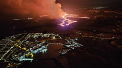
I hope that the Svartsengi sill magma does migrate westward before coming to the surface again -- there are fewer people and less infrastructure on the peninsula tip.

Tourists and the wildlife they come to watch can just drive/fly/swim away from trouble.


Iceland is gorgeous, isn't it.

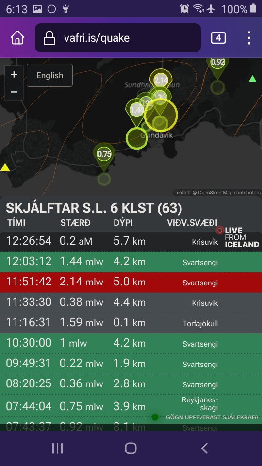
There was a swarm here a few weeks ago and IMO installed a GPS -- on that one large island there, possibly.

Perhaps we'll get some news about that in the next few updates.</layperson speculation>
 

bjdeming

Member
Sustaining Member
Messages
1,623
Reaction score
1,334
Location
Corvallis, Oregon
The Eldey-area seismicity appeared to move farther out to sea and nothing much else occurred.

When I checked a few hours ago, the seismic graphic was totally quiet on the peninsula.

Now there is another 2-pointer near Thorbjorn, per the graphic, and lots of small quakes in the dike area.

An IMO spokesperson tells mbl.is that somethkng may be about to happen (autotranslated).

Given the look of the fiber-optic feed, perhaps something is already happening underground -- don't quote this layperson on that, though! Waiting for more word from IMO, a VONA, and/or visuals from the available cams.
 
Last edited:

bjdeming

Member
Sustaining Member
Messages
1,623
Reaction score
1,334
Location
Corvallis, Oregon
The graphic (note a 1-pointer within 15 minutes -- this is not strong seismicity but a change from the usual microquakes is worth watching):

screenshot_20240313-061353_firefox.jpg


(The 1.59 is in another part of the island.)
 

bjdeming

Member
Sustaining Member
Messages
1,623
Reaction score
1,334
Location
Corvallis, Oregon
Regarding the fiber-optic feed: in the FAQ they note the upper part (yellowish) is dominated by power plant noise (the lower part is ocean noise).

Well, the more intense markers that were apparently quakes when I watched during the dike intrusion on the 2nd, are there now and in the upper part, but the power plant doesn't show its usual steam plume on the Visir cam:


It's more like small bursts. Maintenance, perhaps?

There is something going on there that might be a manmade source of the "quakes"; nothing in the news suggests an emergency, so ?

The stronger quakes and associated smaller ones around Thorbjorn shown on the graphic do reflect earth movements shown on conventional seismometers; something is happening there that may or may not lead to an alert rise, and what we see on the fiber optic cable right now might be associated -- or it might not.
 

bjdeming

Member
Sustaining Member
Messages
1,623
Reaction score
1,334
Location
Corvallis, Oregon
No new quakes in the area show up on the graphic, and things appear to be low-key at the plant. More time should pass before calling this swarm over, but it certainly isn't developing much at the moment.

And magma continues to accumulate down there...
 

bjdeming

Member
Sustaining Member
Messages
1,623
Reaction score
1,334
Location
Corvallis, Oregon
By the time I went to bed, the area was quiet.

Tuned in a little while ago and my head is spinning. Still trying to make sense of it all.

• The current IMO geoscientist note (autotranslated) isn't much changed but they do write that "Yesterday, March 13, around 100 earthquakes were recorded near the Sundhnúks crater series and Grindavík, which is similar to the activity of the last few days." So there's that.

Morning Paper (mbl.is or Morgunbladid) quotes (autotranslated) Armann as saying that things are moving westward and another eruption might not happen until autumn -- probably in the Eldvorp/Eldey area. They also quote him as saying that the Fagradalsfjall 2021 to early 2023 eruption area is now definitely in the Eurasian plate, so that's that (according to the news story).

• BUT: Thorbjorn only realized it was now on the North American plate in February 2024 and suddenly jumped westward 20+ cm? With a resulting short (but devastating) eruption? Am still cogitating on that.

BUT: Both Fagradalsfjall and Thorbjorn are swarming right now on the graphic -- another thing to think about:

screenshot_20240314-035515_firefox-1.jpg


• YET: Activity is also ongoing west, a little ways off the coast, but a little north of the previously noted Eldey swarm:

screenshot_20240314-035405_firefox.jpg


I don't know. We have to think horizontally here as well as vertically, and since it's a mid-ocean ridge (plus a transitional zone between two ridge segments, which is why the peninsula sits at an angle, according to my reading), the sheer geophysics of it all would be mindboggling even if the structure and plumbing at depth, not to mention how mid-ocean ridge processes work, were well known.

All very arcane stuff -- if a significant percentage of the nation's population wasn't along for the ride and if more than 0.013 cu km of magma wasn't already sitting under Svartsengi with the spigot feeding that sill apparently still wide open without our knowing whether it will just sit there or erupt or what.

Armann and Haraldur are among those whose public statements show them emphasizing the horizontal. The recent paper linked at IMO's website focusses on the vertical.

All to the good in terms of 3D thinking.

But we're gonna need a bigger computer (and all I've got is my little ole head ;) ).
 

bjdeming

Member
Sustaining Member
Messages
1,623
Reaction score
1,334
Location
Corvallis, Oregon
No new information but another way to look at the swarming since March 10th:

"Recent seismic activity on the Reykjanes Peninsula, epicenter distribution and rectangular cross section from March 10th based on IMO's hypocenter data. My impression is that there are many near Grindavik, including shallow ones."


They don't include the Eldey region, but I'm pretty sure that northeasterly set just outside the box is Fagradalsfjall.
 

bjdeming

Member
Sustaining Member
Messages
1,623
Reaction score
1,334
Location
Corvallis, Oregon
Nothing on the surface, but the Grindavik area and Fagradalsfjall area swarms continue on the live graphic:

screenshot_20240314-085718_firefox.jpg


Haraldur updated his blog today with a post (autotranslated) cowritten with Mr. Grimur Bornsson.

Morning Paper covered it (autotranslated). It's the "horizontal" POV, and this layperson can't comment on it one way or the other.

Just for balance, here again is IMO's "vertical" viewpoint (autotranslated).
 

bjdeming

Member
Sustaining Member
Messages
1,623
Reaction score
1,334
Location
Corvallis, Oregon
Also, for us, a brief review of the general situation back in January from Volcano Cafe.
 

bjdeming

Member
Sustaining Member
Messages
1,623
Reaction score
1,334
Location
Corvallis, Oregon
IMO addresses the Grindavik-area swarm in their new update (autotranslated):

Seismic activity northwest of Grindavík does not indicate that magma is on the move there​


If the magma were to look elsewhere than the way it has crossed the Sundhnúks crater series, for example west towards Eldvörp or south of Þorbirn, the precursor to a possible eruption in that area would be very intense earthquakes and deformation that would be clearly visible on measuring instruments and satellite images. There are no signs of that at this point.


Quite a few small earthquakes (less than 1.5 in magnitude) have been recorded northwest of Grindavík in the last few days. (See overview picture below.) The activity is mostly located within the sickle that formed on November 10 and is due to the effects of the land giant in Svartsengi, which causes voltage changes within the sickle. The seismic activity is not a sign that magma is on the move in this area.


Trembling_0203_1403_2024_Graben


The image shows seismic activity between March 3rd and today, March 14th. The black lines represent the outer limits of the sickle valleys that formed in connection with the great magma flow on November 10, 2023 and the eruption on January 14 of this year.

Haraldur's blog post suggested that inflow had slowed down, but per IMO, "According to the latest deformation measurements and satellite data, magma accumulation under Svartsengi continues at a similar rate as before the magma flow on March 2. Model calculations based on that data confirm that the magma accumulation under Svartsengi is at the same place and depth as before."

They note all that they can note -- it's uncertain when the next eruption will happen BUT "It should be noted, however, that in the future there is the highest probability that the magma will flow into the Sundhnúks crater series and then a possible eruption in the area between Stóra-Scógfell and Hagafell."

Also, weather will mess with readings for a while.
 

bjdeming

Member
Sustaining Member
Messages
1,623
Reaction score
1,334
Location
Corvallis, Oregon
Per an update in RUV's live coverage (autotranslated), the barriers are holding and lava is flowing west. It's also flowing east and might reach the sea there, which could result in some Kilauea-style lava entry/water interactions (not Surtseyan violence, unless a vent opens underwater, which there is no mention of in the IMO site, either).

Expect small explosions and some acid gas release if that happens.

Per RUV, there are some houses in the eastern branch's path. Also, Civil Defense notes, per RUV, that fiber optic cables along the roads that lava flows will cut could be damaged.

No word yet about threats to the power plant, thankfully.

Spectacular image on IMO's page:

Hlusta


Eldgosið séð úr eftirlitsflugi Landhelgisgæslunnar með Grindavík í forgrunni. (Ljósmynd: Almannavarnir/Björn Oddsson)


Eldgos hafið​


17.3.2024


  • Eldgos er hafið á milli Hagafells og Stóra-Skógfells.
  • Upptökin eru nær Stóra-Skógfelli, á svipuðum stað og eldgosið sem varð 8. febrúar.
  • Aðdragandi gossins var stuttur en gosið hófst kl. 20.23.
-- Autotranslated source
 

bjdeming

Member
Sustaining Member
Messages
1,623
Reaction score
1,334
Location
Corvallis, Oregon
Reportedly (autotranslated), machines are on place at one of the towns in the eastern flow's path, and they are going to try for a barrier there.

Another story from Morning Paper (autotranslated) covers the power plant situation, which is complex. The western flow branch is threatening some parts of its infrastructure, but this time they've got backup.

Meanwhile, east of Grindavik one of the two threatened roads is under lava.

This outbreak is quitr fast and powerful. Hopefully that means it won't last long; if it does, that could really test all the work Iceland has done since this all began.

Right now, winds are blowing the plume mostly out to sea.
 
Last edited:

bjdeming

Member
Sustaining Member
Messages
1,623
Reaction score
1,334
Location
Corvallis, Oregon
Summing up news reports, the western flow's lava is crossing the same road section at the same place it did in February. The geothermal heat pipes are more protected now and it's really just a wait-and-see situation now.

To the east it's the town of Hraun -- ironically, that means "lava," I think -- that is threatened and where they're building a defense.
 

bjdeming

Member
Sustaining Member
Messages
1,623
Reaction score
1,334
Location
Corvallis, Oregon
Morning Paper cam close-up. I'm speechless. Humanity has never done this on such a scale before. May it continue to hold!


bjdeming

Member
Sustaining Member
Messages
1,623
Reaction score
1,334
Location
Corvallis, Oregon
Here's what the start looked like on that research fiber optic cable feed: wow!


bjdeming

Member
Sustaining Member
Messages
1,623
Reaction score
1,334
Location
Corvallis, Oregon
Somebody got it on cam, too!


bjdeming

Member
Sustaining Member
Messages
1,623
Reaction score
1,334
Location
Corvallis, Oregon
Heh. From Iceland Review;

Grindavík volcanic eruption January 2024


Photo: Golli. January 2024 eruption by Grindavík.

New Eruption Begins in Reykjanes​


At 8:22 PM Icelandic time this evening, the Icelandic Met Office released a statement saying that due to increased seismic activity and ground surface distortions in the area between Hagafell and Stóra-Skógfell, they believed it likely that an eruption would occur.

An eruption began one minute later, RÚV reports...
 

bjdeming

Member
Sustaining Member
Messages
1,623
Reaction score
1,334
Location
Corvallis, Oregon
I've been reading up on this and understand that the first crustal failure triggers more, and because of the regional stress field the new failures open in an en echelon pattern.

It's another unique view that geologists so seldom get to see.


Let's just hope that one of those crustal failures doesn't happen again behind the barriers.
 
Back
Top