• Welcome to TalkWeather!
    We see you lurking around TalkWeather! Take the extra step and join us today to view attachments, see less ads and maybe even join the discussion.
    CLICK TO JOIN TALKWEATHER

Iceland's Fagradalsfjall Fires

bjdeming

Member
Sustaining Member
Messages
1,593
Reaction score
1,310
Location
Corvallis, Oregon
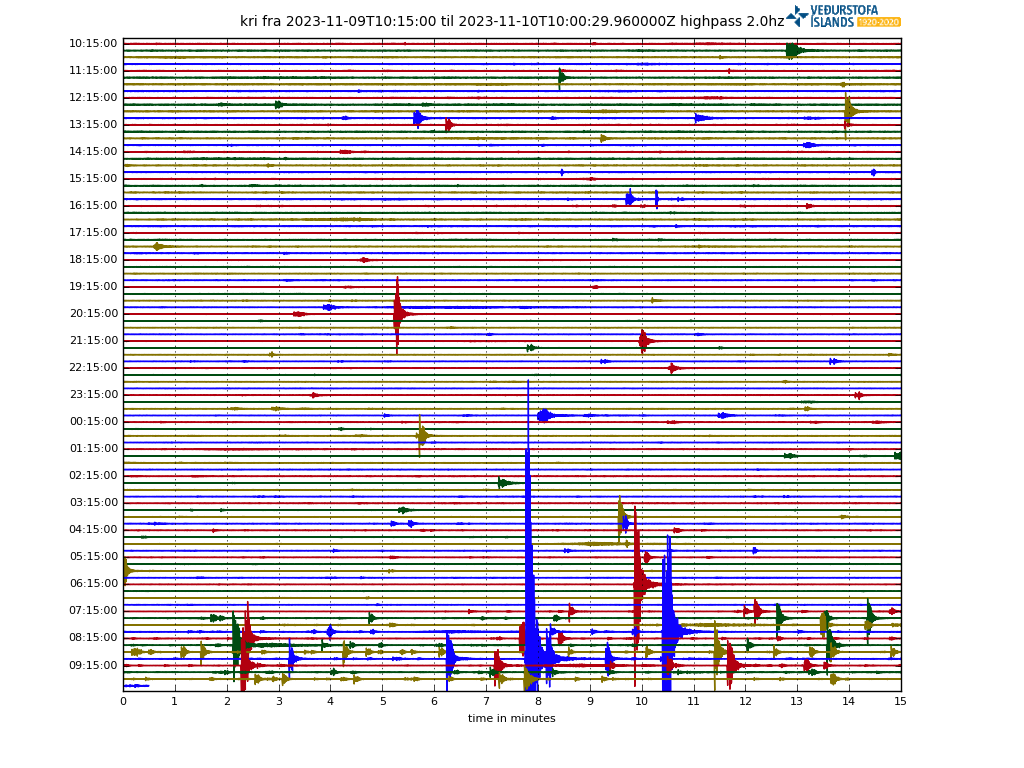
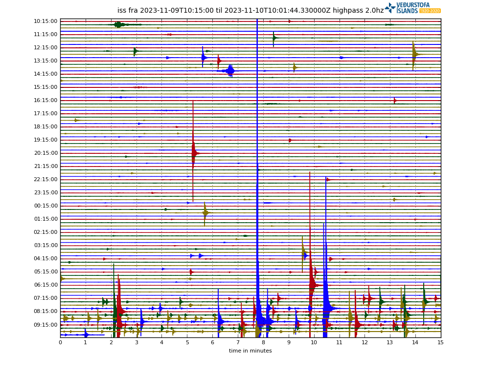
As of 2048 UTC on November 9th, there's no eruption but there are geologic developments: the intense quake swarm starting around midnight local time, for instance, and human developments such as the decision to build lava barriers around the geothermal plant near the Blue Lagoon and RUV putting Thornbjorn camera live on YouTube today.

Cam update, November 12, 2247 UTC:

RUV had stopped all cams except Sylingafell South --


-- but, not surprisingly (see "convoluted stuff" post, page 2), they have begun live streaming from Thorbjorn again:


A new cam on Husafell:


And a mosaic:


There are also several mbl.is cams streaming, including at one of the earlier eruption sites -- Litli-Hrutur -- so that's still a possibility, too.

 
Last edited:

bjdeming

Member
Sustaining Member
Messages
1,593
Reaction score
1,310
Location
Corvallis, Oregon
Human developments:

  • The water has been closed for a week, but there are still guests at the Blue Lagoon's hotel. Many freaked out and ran outdoors when some of last night's quakes caused rockfalls.
  • I guess it's really important that the power plant just to the right of the Lagoon on that RUV cam stay open. They are going to build a lava barrier around it. From several articles I've read, the generators now in Grindavik can power the place but cannot heat houses. Icelanders use geothermal energy and apparently it is not simply a matter of switching your household wiring over to keep the furnace going. They're telling people that if worse comes to worst they need to get into a single room to make the most of the 1 or 2 kilowatts that will trickle in. :(
  • Cracks are appearing in local roads, but this happens whenever there are earthquakes and the cracks are very small. Still, there is a lot of understandable anxiety in the area and that mbl.is autotranslated link above now carries some human interest stories about the response to last night's swarm.
 

bjdeming

Member
Sustaining Member
Messages
1,593
Reaction score
1,310
Location
Corvallis, Oregon
Geology:

From IMO:

Updated November 9 at: 12:10 p.m


Around 1400 earthquakes have been recorded in the last solar cycle. Activity increased from midnight and there have been seven earthquakes above magnitude 4 since then. The largest earthquake measured M4.8 at 00:46 just west of Þorbjörn and is the largest earthquake since the earthquake series began on October 25. Scales over 4 in size were measured in the area from Eldvörp to the area east of Sýlingarfell. While the accumulation of magma continues, seismic activity can be expected on the Reykjanes Peninsula because the magma intrusion causes increased tension in the area.

According to GPS data at midnight, land was still measured in the area. The GPS data is being reviewed in relation to the seismic activity tonight. If we consider October 27 as the starting date of the expansion until today, the country has risen fairly evenly, although the acceleration of the process has been measured differently between days. The seismic activity last night and this morning is an example of this frenetic seismic activity that can be expected while magma accumulation is in progress. The fact that there are now larger earthquakes than before in the area does not necessarily mean an increased rate of magma accumulation.

There haven't been any more really strong ones (which I think is what the webicorders on the public-facing IMO website pick up) since that overnight swarm:

kri_highpass_2.0.png


iss_highpass_2.0.png


But that was one of the things that indicated we should probably have a dedicated thread: I don't know if it was some bubbles or rock cracking briefly or what, but the magma is apparently not going to just sit down there quietly and inflate. It is pressurized.

There will be other episodes. Probably. Volcanic uncertainty is such a problem. The second of three things that led to this thread was that, in the face of so much uncertainty, they are planning to build a huge lava barrier, in winter, near the Arctic Circle:


The third thing was this news (autotranslated) that geothermal areas are moving around at a site 4 hours' drive inland from Grindavik:

screenshot_20231109-133300.png


(Grindavik, unlabeled, is on the left.)

The Hveravellir area looks to be kind of in the outer edge of the seismicity maps on IMO's website; however, I have read absolutely nothing to connect it with the magma pools at the Thorbjorn area (5 km down) and at Fagradalsfjall (10 km down). Physically, it is separate.

But it's in the general area and this is the Reykjanes Ridge stirring for the last couple years -- after a quiet spell of 800 years -- so...who knows? It's worth mentioning, mbl.is thought, and definitely the overall unrest requires a thread now.

BTW, the center of the mantle plume that keeps these sections of the Mid-Atlantic ridge above sea level is presumed to be further east, under Bardarbunga (not anywhere near the current events).

From the little I was able to understand of reading, the Reykjanes Peninsula/Ridge geology is challenging even for Ph.D.'s, and that certainly must make the job of managing a volcano emergency here even tougher.
 
Last edited:

bjdeming

Member
Sustaining Member
Messages
1,593
Reaction score
1,310
Location
Corvallis, Oregon
People stuff: He actually does give every Icelandic name/word his best effort! ♥️


bjdeming

Member
Sustaining Member
Messages
1,593
Reaction score
1,310
Location
Corvallis, Oregon
Geology:

News reports quote officials saying that it was a very quiet night at the weather office, with 200 low-level quakes since midnight.

i saw the northern lights on the cam once. :) Otherwise, there seemed to be activity ongoing (some headlights, including a vehicle driving on the plain somewhere between Thorbjorn and the Blue Lagoon lights) up to around 2 a.m. local. Then nothing.

However, the public-facing webicorders now show what looks to this layperson like another swarm -- low level, but rock-breaking activity (again, layperson opinion only).

website2.png


website3.png


And this (autotranslated) is up at mbl.is:

"The roof is giving in, that's just the way it is. For me, it's only a matter of days before this happens," says Ármann Höskuldsson, a volcanologist and geochemist at the University of Iceland's Institute of Geosciences, when asked about the earthquake that hit the Reykjanes Peninsula last night.


When asked, Ármann says that it is not a question of whether there will be an eruption on the Reykjanes Peninsula, but when...

He goes on the describe the power plant's importance.

It's a major local concern but we all have a stake in the size of the eruption, if and when it occurs. Will it be on the order of the last two fires or, given the presence of a sill this time, something larger?

Well. I can't stay awake any longer. It does look to be another interesting day, though.
 

bjdeming

Member
Sustaining Member
Messages
1,593
Reaction score
1,310
Location
Corvallis, Oregon
Yep.


Per IMO's most recent updates (there will certainly be more):

Icelandic Meteorological Office
Menu .

Listen
New-10-nov-card
Past earthquakes since midnight today, November 10.

A danger level has been declared due to increasing seismic activity​

This sequence of events could lead to an eruption. Flight color code has been moved up to orange​

10.11.2023

Updated November 10 at: 19:00


The seismic activity currently measured at Sundhnjúka crater is limited to an area about 3 km northeast of Grindavík. The shallowest earthquakes that are currently measured are at a depth of about 3 – 3.5 km.
The signs that can be seen now at Sundhnjúka crater are comparable to those seen on the eve of the first eruption at Fagradalsfjall in 2021 and are very similar to the seismic activity that was measured about a month before the eruption. Looking at the sequence of events that culminated in the eruption that began on March 19th, and while the seismic activity has not subsided significantly so far, the most likely scenario is that it will be several days rather than hours before magma reaches the surface. If a crack were to appear where the seismic activity is at its highest now, lava would flow to the southeast and to the west, but not towards Grindavík.

Composite-picture-10-nov

Earthquakes on Nov. 10 (until 18:48). Seismological stations of the Icelandic Meteorological Office are shown with triangular symbols. Turbulence at the four stations around the seismic tower shows a large increase since 15

Updated November 10 at: 5:45 p.m

The National Police Chief, in consultation with the police chief of Suðurnes, declares a state of emergency for Civil Protection due to the intense earthquake since 15:00 today at Sundhjúkagíga, north of Grindavík. Earthquakes can become larger than those that have occurred so far, and this sequence of events could lead to an eruption. The flight color code has been moved up to orange. The Icelandic Meteorological Office is closely monitoring the progress.

As before, residents are encouraged to follow the information on the Public Safety website . The danger level of the Civil Protection means that the risk is increasing and measures are being taken to ensure the best possible safety of those who live/stay in the area.

Updated November 10 at: 1:00 p.m

Right now, at 12:44 a magnitude 4.1 earthquake occurred right at Sýlingarfell, which is west of Sundhnjúka crater. The craters are about 2-3 km northeast of Grindavík. A fairly intense earthquake began around 7 am this morning in these areas, and almost 800 earthquakes have been recorded there since midnight, nine of which are of magnitude 3 or greater. The depth of the earthquakes is about 5 km. Such earthquakes have been recorded in this area before. It cannot be ruled out that the seismic activity at Sundhnjúka crater is due to magma at a considerable depth.
Magma accumulation continues at Þorbjörn at the same depth and similar speed as before. It is accompanied by intermittent seismicity, similar to what was observed yesterday and this morning. While magma accumulation continues, one can expect continued seismic activity resulting from stress release in the area. Earthquakes up to M5.5 in size can be expected in such gusts. At this stage, there is no evidence of magma making its way to the surface.

Part of that eruptive location precision is probably due to an extra network of GPS stations, established a couple days ago.

There is a discrepancy between what Jón Frimann shows on his seismometers and IMO's webicorders. Here is his image of some, which he calls the strongest activity he has ever seen (caveat: he runs a small and very unofficial network but has been consistent about it for the twelve years or so I've followed him online; take it FWIW):

Screenshot_20231110_174355.png


That's almost 200 km away from the site, and though it is from private unofficial equipment, it at least deserves a mention.

Frimann also notes (and I don't know whether accurately or not right now):

Icelandic Met Office has confirmed that magma is now rising to the surface in the area of Sundahnjúkar crater row. This does not seems to be connected to Svartsengi magma (Reykjanes volcano) dyke intrusion. How much magma and what volcano it is connected is unclear at the writing of this article. This might not be connected to Fagradalsfjall volcano also. If that is the case, it means this either a new unknown volcano at this location or rift eruption not connected to any volcano. It is going to take a while to get an answer to that question once the eruption has started.

I've seen no mention of that question elsewhere yet.

ALWAYS go with official sources in a volcano crisis -- Icelanders are incredibly fortunate to have such reliable ones.

My concern is that, if Frimann is on to something here, a big if in any lay interpretations (including my own), it might turn out to be a larger eruption that previous ones. Most likely still effusive, as there are no glaciers sitting here to feed Eyjafjallajokull-style explosions, but still possibly big with correspondingly big pollution.

That's for the future. Right now the question is whether a town will need evacuation for the first time in around fifty years.

Stay safe, Icelanders.
 
Last edited:

bjdeming

Member
Sustaining Member
Messages
1,593
Reaction score
1,310
Location
Corvallis, Oregon
 

bjdeming

Member
Sustaining Member
Messages
1,593
Reaction score
1,310
Location
Corvallis, Oregon
Sigh.

"One screenshot for the history books." (Twitter translation)


bjdeming

Member
Sustaining Member
Messages
1,593
Reaction score
1,310
Location
Corvallis, Oregon
Some confirmation of Frimann from another lay Icelandophile who seems to know his way around the eruptions there. (His answer to a query in one of the threads was that the eruption likely will be bigger and a little more explosive than the other three (I must have missed one in my post):


And, three hours ago:


bjdeming

Member
Sustaining Member
Messages
1,593
Reaction score
1,310
Location
Corvallis, Oregon
Just in from mbl.is: They will evacuate Grindavik.

Live stream from RUV (text autotranslates but not audio.)

While noting that if this were an emergency evacuation they would need to get out in less than an hour, the RUV bloggers note:

RÚV's logo


News
National news
Alþingi
Turns on
Economy
Consumer Affairs
Politics
Foreign news
Culture and current affairs
Sports

Earthquakes on the Reykjanes Peninsula

Grindavík has been evacuated and the civil defense emergency level has been declared​

  • We stream directly from the National Defense Coordination Center in Skógarhlíð, where Víðir Reynisson reviews new information from the National Defense.
  • The police chief in Suðurnesj in cooperation with the Civil Defense have decided to evacuate Grindavík. Residents are given 2-3 hours to evacuate.
  • Civil defense preparedness has been moved to emergency level.
  • The Met Office's meters have shown clear signs of the formation of a magma tunnel to the surface.
  • It cannot be ruled out that a magma tunnel lies under Grindavík.
  • Seismic activity increased a lot after three o'clock today.
Ragnar Jón Hrólfsson , Ingunn Lára Kristjánsdóttir , Ásta Hlín Magnúsdóttir and Róbert Jóhannsson
November 10, 2023 at 09:16,updated at 3:34 p.m
A
A
A
Civil defense information session due to earthquakes on the Reykjanes Peninsula.  Willow Reynisson.


RÚV – Ragnar Visage


NEWS SHIFT

Nýtt

Seyðisfjörður síðast rýmdur á Íslandi​

Þrjú ár eru liðin frá því bær var síðast rýmdur á Íslandi en það gerðist í kjölfar aurskriða sem féllu á Seyðisfjörð. Bærinn var rýmdur og voru íbúar og aðrir fluttir í fjöldahjálparstöð á Egilsstöðum.
Víðir talaði um að það ástand sem nú stendur yfir í Grindavík væri í líkingu við það sem átti sér stað í Vestmannaeyjum þegar heimaeyjargosið átti sér stað árið 1973.

4 minutes ago

Relief from anxiety and depression​

On the Public Safety website you can find useful information and coping strategies.
In prolonged uncertainty and earthquakes, it is normal to feel anxiety and discomfort. Children are especially vulnerable and deserve special attention. It is good to get information about what can be done to reduce discomfort, and here are some tips:
Helpline 1770
Education for children
Advice for parents of children and young people
A conversation about volcanic eruptions with children
Red Cross - Useful information about evacuations

5 minutes ago

Unplugged electrical appliances​

People are asked to unplug electrical appliances. The electricity has been flickering and it is good to avoid the risk of fire.

7 minutes ago – updated

Drive carefully​

Víðir asks people to drive carefully from home, it is dark and there are many people on the road. There is no need to stop at the collection center in Grindavík.

8 minutes ago

Not an emergency evacuation​

If it was an emergency evacuation, people would have to leave within 30 to 40 minutes. People don't have to go to any lengths. Remember necessities, medicines and other things before leaving home.

9 minutes ago

Contractors leave Svartsengi​

Contractors have been asked to leave the area at Svartsengi until the Civil Defense has figured things out. The power plant can be remotely controlled.

10 minutes ago

Leave Grindavík before three o'clock​

It would be very good if the residents of Grindavík left before three o'clock. The rest will be emergency responders and key employees in Grindavík.

11 minutes ago

Quick turn of events​

Víðir cannot say how far the magma tunnel has reached, but the sequence of events has been quite fast in the last few hours. It would be good if people could leave Grindavík in the next two to three hours.

The dyke, per other tweets is close to and possibly under Grindavik.
 
Last edited:

bjdeming

Member
Sustaining Member
Messages
1,593
Reaction score
1,310
Location
Corvallis, Oregon
 

bjdeming

Member
Sustaining Member
Messages
1,593
Reaction score
1,310
Location
Corvallis, Oregon
Just added this to the links in first post: NOAA/CIMSS Volcanic Cloud Monitoring Portal.

Any North Atlantic air circulation/forecast models links to share?
 

bjdeming

Member
Sustaining Member
Messages
1,593
Reaction score
1,310
Location
Corvallis, Oregon
RUV, ten minutes ago:

What are the signs of magma?​

Heavy sliding in the Sundhnúka craters could indicate that the magma has reached the surface.
The southern end of the series of craters is about 1 km from the northernmost settlement of Grindavík and about 1500 meters from the power plant in Svartsengi.
The Icelandic Meteorological Office says there has been a big change in the seismic activity and it is moving south towards Grindavíkurbær. According to the Icelandic Meteorological Office, there is a possibility that a magma corridor has extended under Grindavíkurbær.
The amount of magma involved is significantly greater than what has been seen in the largest magma intrusions that occurred in connection with the volcanic eruptions at Fagradalsfjall.
The Southern Volcanoes and Natural Resources Group published this image that shows how gliding works.
fri_20231110_234240205

I haven't even had time to check the cam yet! (Edit: Just did -- no unusual glow; the cam might not extend that far to the left/east.)
 

bjdeming

Member
Sustaining Member
Messages
1,593
Reaction score
1,310
Location
Corvallis, Oregon
"Gliding" is rifting. That's a somewhat larger scale than dyke-fed fissuring. :(
 

bjdeming

Member
Sustaining Member
Messages
1,593
Reaction score
1,310
Location
Corvallis, Oregon
A J. Frimann update:

  • Earthquake activity remains heavy, but is lower than it was at around 17:00 to 19:00 UTC. This might change again without warning.
  • GPS data suggests this is more magma than in all of last three eruptions combined.
  • This magma might be from Fagradalsfjall volcano. This is currently only an idea. That means the magma in Reykjanes volcano has not started to move to the surface. That might also happen without warning at any time, since that inflation continues.
Of note, I did find a tweeted scientist interview statement that confirmed the two magma systems Jón mentioned earlier but haven't had time to post it.
 

bjdeming

Member
Sustaining Member
Messages
1,593
Reaction score
1,310
Location
Corvallis, Oregon
This mbl.is article (autotranslated) has a picture of the crater mentioned above where possible "sliding" was noted. The RUV cam is on Thorbjorn, the crater rim closest to us. Note steam from the geothermal plant for orientation.
 

bjdeming

Member
Sustaining Member
Messages
1,593
Reaction score
1,310
Location
Corvallis, Oregon
Things have gone a little quiet for the moment. Whew!

They say the roads are slippery and that nobody needs to rush (there was a light dusting of snow on the ground this morning).

Shelters for the Grindvikings -- yes, that's how news refers to them! -- are open over many parts of the country. Many reportedly are going to homes (family and friends).

Just going through other tweets and saw this --


-- it probably wasn't them I saw last night driving over the plain, but it could have been other volcanogists. :cool:
 

bjdeming

Member
Sustaining Member
Messages
1,593
Reaction score
1,310
Location
Corvallis, Oregon
Whoa, that was fast, from the first sign of magma movement today to this now, per RUV:

The evacuation of Grindavíkur town is complete​

Grindavíkurbær has been evacuated, the evacuation ended just now and went well. Responders are on the job, but everyone else has left town.
The Grindvíkings showed great consideration, the published plans were followed during the evacuation, and according to the public safety, it went without a hitch.
Most of the Grindvíks are staying with friends and family, but a few are in mass aid centers. Most of them in Kórn in Kópavogur.

Fyrir 33 mínútum

Activity under Grindavík suggests that the magma tunnel reaches under the town​

In this picture showing the seismic activity of the last six hours, you can see how the seismic activity on the Reykjanes Peninsula has increasingly moved under Grindavík.
fri_20231111_004833510

Elísabet Pálmadóttir, a natural hazard expert at the Icelandic Meteorological Office, confirms this, the seismic activity has moved south towards Grindavíkurbær.
Data from the meteorological office indicate that a magma tunnel has extended under Grindavíkurbær. That's why Grindavíkur town was evacuated and the Civil Defense emergency level was declared. It cannot be ruled out that a volcanic fissure may open within the town limits.
At this stage, however, it is difficult to say exactly if and where magma can reach the surface.

Well done. Of course, law enforcement, scientists, and emergency personnel are still in the zone.

The dyke could conceivably reach the sea, which would certainly increase the eruption's explosiveness.

Well, it's a waiting game now.
 

bjdeming

Member
Sustaining Member
Messages
1,593
Reaction score
1,310
Location
Corvallis, Oregon
We might not have to wait long - many, thus far small quakes have begun again. (Correction: At least one was reportedly a 4-pointer.)

Tweeted an hour ago (visualization software is Leaflet, but I'm desktop challenged at the moment):


Dr. Winder did some followup on that seismometer tweet, though it was posted two hours ago and isn't part of the current swarming AFAIK.


Confirms the surprising intensity that Jón Frimann reported seeing on his own equipment earlier.

RUV reports that the main focus was getting people out of Grindavik and authorities didn't stop to do a survey to assess damage from the quakes but it exists there, notably with heavy damage to a nursing home.
 
Last edited:

bjdeming

Member
Sustaining Member
Messages
1,593
Reaction score
1,310
Location
Corvallis, Oregon
PS: That new seismicity apparently (autotranslated) is southwest of Grindavik now.
 
Back
Top