Iceland's Fagradalsfjall Fires

bjdeming

Member
Sustaining Member
Messages
1,625
Reaction score
1,335
Location
Corvallis, Oregon
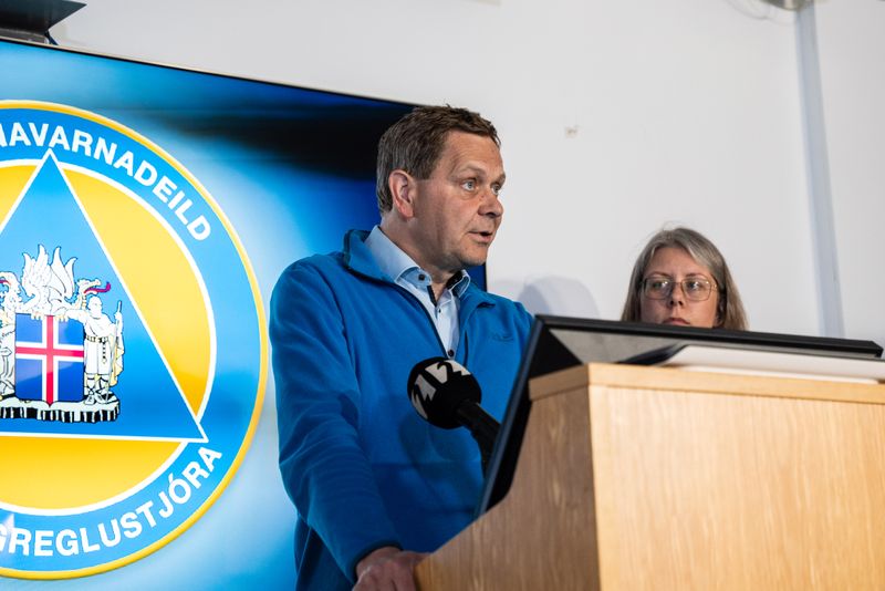
They were interviewing Grindavik's mayor earlier today when one of the quakes hit.


I'd rather sit through one of those mine-collapse quakes in McCalla than one like this where magma is moving under me! :oops:
 

bjdeming

Member
Sustaining Member
Messages
1,625
Reaction score
1,335
Location
Corvallis, Oregon
Just found and added this to cams at start of thread.

New cam from RUV posted four hours ago; it's labeled "Grindavik-Sylingafell-Nordur," but we'll have to wait until dawn for a visual orientation:


Of note, Sylingafell is the middle crater in this article's image, and the third -- farthest from the photographer -- is, I think, the one underneath which the currently active dyke begins. (? Nordur)

Update: Thanks to Volcano Discovery, that is the north-facing cam on Sylingafell.

Here is the south-facing (Sudur) Sylingafell cam:


Of note, I found out yesterday, dawn doesn't come until somewhere between 8:30 and 9 a.m., local time.

Which is good for us: lava shows up well at night. During the day, you have to look -- at least at first -- for smoke and maybe some outgassing to see if there is an eruption.
 
Last edited:

bjdeming

Member
Sustaining Member
Messages
1,625
Reaction score
1,335
Location
Corvallis, Oregon
They are removing responders from the area, per mbl.is (autotranslated), and -- I'm just gonna put this out here (it's explained in the story) -- they have requested Thor (Þór) to back off.

Per RUV:

The magma tunnel lies under Grindavík - "A very big event"​

The meeting between the scientists of the meteorological office and representatives of the civil defense ended just before four o'clock. There, data was reviewed that show that a magma corridor now runs under Grindavíkur town.
Based on the data, a decision was made to call all responders from Grindavík.
The corridor runs from Sundhnjúkagígir and from there to the southwest through Grindavíkurbær and onward. The size, length and volume of the magma tunnel is not known. It is difficult to say exactly how deep the magma is, but the earthquakes that have been recorded in the last hours in the area originate at a depth of two to three kilometers.
A natural disaster expert at the Icelandic Meteorological Office says it is clear that this is a very large event.
 
Last edited:

bjdeming

Member
Sustaining Member
Messages
1,625
Reaction score
1,335
Location
Corvallis, Oregon
From translation of the thread, this is some of the data that led to their decision (which reportedly they will review at 6 a.m. local, so...right about now):


Check out the thread; it's interesting.
 

bjdeming

Member
Sustaining Member
Messages
1,625
Reaction score
1,335
Location
Corvallis, Oregon
No change in status, per mbl.is, after the 6 a.m. meeting. They'll review it at 8 and then there is a big meeting at 9:30 local.

There is some speculation on Twitter that photos of the damaged nursing home in Grindavik suggest a ground crack under the building.

Solid news is that yesterday's quakes broke one of the main geothermal heating water ducts -- one close to the nursing home. So some of those evacuated homes now are without heat.

As for today, this was tweeted by about two hours ago:


bjdeming

Member
Sustaining Member
Messages
1,625
Reaction score
1,335
Location
Corvallis, Oregon
In this summary posted about forty minutes ago on the RUV live stream/blog they note that the dyke, which now has a name apparently, is under the sea now (if that seems strange, remember that this isn't the continent/seafloor many of us are used to -- it's a submarine mountain range (mid-ocean ridge) that has risen above sea level on a mantle plume: it's all the same formation geologically for the dike).

RUV's summary also is a good review of the last crazy 12-plus hours.

The situation after the night​

Various things have been in the news due to earthquakes at Grindavík since last night.
  • Earthquake activity increased very much yesterday and the source of the earthquakes began to move closer to Grindavík.
  • Kvikugangur runs from Sundhnjúkagígur and from there to the southwest through Grindavíkurbær and continues under the sea.
  • A fissure could open anywhere in that magma corridor. Including whether within the town limits of Grindavík or under the sea.
  • A considerable amount of magma is moving there, much more than in eruptions on the Reykjanes Peninsula in recent years.
  • A natural disaster expert makes it clear that this is a very large event.
  • The evacuation of Grindavík was announced just after 11 o'clock last night. Víðir Reynisson did it live from the Civil Defense Coordination Center.
  • The evacuation of the town was completed around half past two, by which time the residents had left their homes, but the responders were still on duty.
  • After a meeting between civil defense and experts at the Icelandic Meteorological Office between three and four in the morning, it was decided to call all emergency personnel from the town as well.
  • The town is now deserted except for the fact that police officers are manning the barrier posts.
In about an hour and a half they will be having the big meeting, with data analysis, models, etc.

If and when there is an eruption -- that's when the trouble starts, in this layperson's opinion.


The last 12-plus hours might turn out to have been just the opening credits.

Or not. I really hope "not."
 
Last edited:

bjdeming

Member
Sustaining Member
Messages
1,625
Reaction score
1,335
Location
Corvallis, Oregon
Well, I'm bushed and will just add this recent RUV note before heading for bed.

The magma tunnel seems to have reached its full width​

It seems that the magma tunnel under Grindavík reached its full width around midnight. "It has been night since then and it is only possible to watch this through GPS devices and seismometers," says Magnús Tumi Guðmundsson, professor of geophysics.
fri_20230710_225025168

"This insertion is a very big event and it happened very quickly. So there is great uncertainty as to what will happen in the near future, but it could become clear today. "The night has been busy with people, including at the Met Office, going over the issues."
Magnús says that it is completely uncertain whether the swarm will break up, considering the behavior, it is looking for every way to go to the side. We have no idea how big the eruption would be if it did. There is nothing certain about the subject. There is a lot of uncertainty about how big it will be on the surface and where exactly it would erupt if it did."

You don't often hear this from scientists, and it is a result of the complexity of the Reykjanes Volcanic Zone and probably also the short length of time that scientific measurements have been possible.

One good thing is that the dike isn't widening any more. But then later he mentions things wanting to go sideways -- just a layperson opinion, but it could point to this not being a simple feeder-dike situation, as it was with the other Fagradalsfjall eruptions (and most other recent eruptions like Bardarbunga and Eyjafjallajokull).

Just check out the deformation shown above in that tweeted InSAR imagery. This influx of magma is big, the amount and rate of ground deformation over the last 24 hours or so have been mind boggling, and other volcanic systems are probably affected, too.

Magnus Timu, as the media call him*, is being straightforward. This is unprecedented; it could unfold in a number of different ways, from no eruption at all to something quite bad; and the scientists must proceed cautiously, hoping for the best but keeping people mentally prepared for worse developments just in case.

G'night.


*During the start of the 2022 eruption, media and scientists were out at the remote site. Magnus Timu Gundersson was going to be interviewed but for some reason the online feed was rolling on the preliminary stuff. Those media people would have the doctor stand in one place, then another, then move him again, just setting things up; lots of people at his level would have gotten huffy about it but he just went along with whatever and then talked about volcanism that was going on just a few hundred yards away (which was where he probably wanted to be). It was a wonderful and unintended lesson in humility and having the right priorities (keeping people informed and therefore safer).
 

bjdeming

Member
Sustaining Member
Messages
1,625
Reaction score
1,335
Location
Corvallis, Oregon
I seem to have slept through the same hours that big meeting happened. :)

This came out at IMO a little while ago. Volcanologists don't talk much more bottom-line than this. I will not speculate about it, but it's a very serious situation.

Updated November 11 at: 18:20


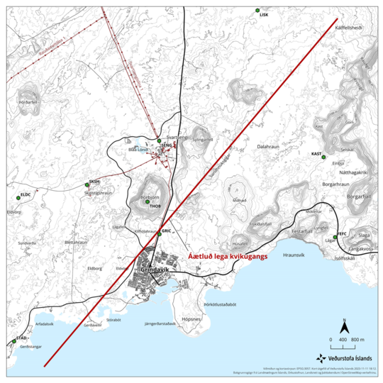
At 6 p.m., the status meeting of scientists at the Icelandic Meteorological Office and the University of Iceland and Civil Defense ended, where the interpretation of the latest data received since noon today was reviewed. Models were created based on satellite images and GPS measurements. Models show that the extent of the magma tunnel is significant and magma is approaching the surface. The corridor extends from Kálfellsheiði in the north and runs just west of Grindavík and into the sea in a southwesterly direction. The magma tunnel is about 15 km long and the magma lies at a depth of about 800 m where it is shallowest. It should be noted that the models are based on satellite data that is about 12 hours old, so it must be assumed that the magma has moved closer to the surface than 800 m. Based on this, it can be concluded that there is a significant chance that magma will manage to break its way to the surface. There is also an increased chance that magma can emerge on the ocean floor.

Earthquake activity has decreased a lot this afternoon. It is believed that the main reason for this is a large release of tension in the area due to yesterday's earthquake and deformation due to the magma tunnel. Because of the release of tension, it is likely that the magma will have an easy way to the surface, and therefore it cannot be assumed that eruption turbulence will be visible on the meters before the eruption begins.

Based on the interpretation of the latest data, the Norwegian Meteorological Agency has sent a recommendation to civil protection that the probability of an eruption has increased since this morning and that an eruption can start at any time in the next few days. Models also indicate that magma may emerge at the southern end of the magma tunnel just outside Grindavík. The probability of a volcanic eruption on the seabed has therefore increased and it is necessary to prepare for the possibility of an explosive eruption. A danger zone has been defined based on the location of the magma tunnel.

Map-rains-11-nov


Map showing the approximate location of the magma tunnel at Grindavík.
 

bjdeming

Member
Sustaining Member
Messages
1,625
Reaction score
1,335
Location
Corvallis, Oregon
Further info from the RUV stream/blog indicates some changes in the seismicity (not major) and an indication that the government is looking at the big picture: the peninsula, not just a part of one volcanic system (which is usually what is involved):

  • In the afternoon, the seismic activity has moved back to the north, approaching the center of the magma tunnel.
  • ...
  • There is considerable damage to the infrastructure in Grindavík.
  • The Prime Minister's bill on the protection of important infrastructure on the Reykjanes Peninsula was distributed in Alþingi this afternoon. The Minister of Justice would be authorized to have dikes built, embankments made over utility structures and trenches dug to prevent damage.
Update, same source (I'm not sure what events she is referring to but hope it is not the Skaftar Fires):

With greater events in later times​

The situation is complicated, says Prime Minister Katrín Jakobsdóttir. She says that she has met several Grindvíkin today. This is with bigger events in later times according to her.

There will probably be a cabinet meeting tomorrow and the bill on the protection of infrastructure on the Reykjanes Peninsula will be circulated in Althingi.

Good old Þorvaldur Þórðarson (one of the coauthors on that Skaftar Fires paper)! That was big but not 1783 sized.

 
Last edited:

bjdeming

Member
Sustaining Member
Messages
1,625
Reaction score
1,335
Location
Corvallis, Oregon
Ten minutes ago, same source (link added):

Worst case scenario likely​

The worst possible scenario could be coming true, according to geophysicist Ármann Höskuldsson, who was interviewed on TV news tonight. The eruption could be worse than the Vestmannaeyja eruption if the magma erupts in or near Grindavík.

That was the "spray seawater on the lava" one. Of note, it happened on a small island. This is the Reykjanes Peninsula they're talking about.
 

bjdeming

Member
Sustaining Member
Messages
1,625
Reaction score
1,335
Location
Corvallis, Oregon
That interview with Dr. Thordarsson (autotranslated) has a lot of interesting information.

For instance (video of Holuhraun eruption added -- can't delete the mbl.is logo):

mbl.isMenu

"Could be similar in size to Holuhraun"​

Þorvalður takes a similar line in an interview with mbl.is. "What is being thought now and people are realizing. This could be something of a similar magnitude to Holuhraun 2015."


To recap, the Holuhraun eruption was the largest lava eruption of this era and either the largest or the second largest lava eruption since the Skaftár fires of 1783, according to Þorvald. Reminds him that they were accompanied by the so-called Moðuharðindi.

Þorvalður notes that this is the worst scenario, but still something that needs to be kept in mind.
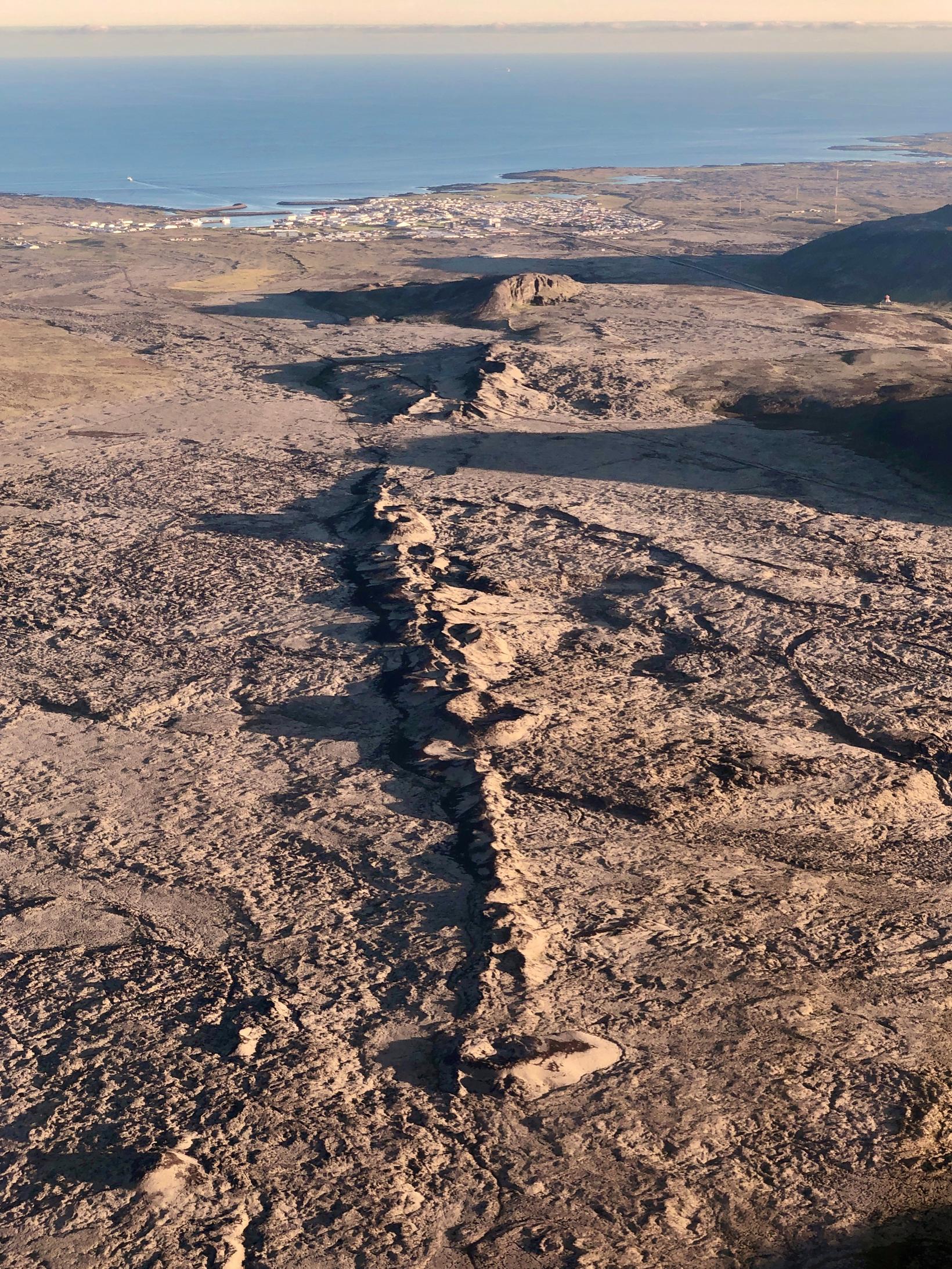
The Sundhnúka crater series runs south-southwest to Grindavík.
The Sundhnúka crater series runs south-southwest to Grindavík. Photo/Siggi Anton

"Pretty complex crack"​

The Sundhnúka crater series is a series of craters over a 7-10 km section, but its southernmost part is only about 800 meters north of Grindavík. Þorvalður says that it is not entirely known whether it was formed in one eruption or several, but that scholars have so far believed that it was formed in one eruption. However, this is "a rather complicated crack."
"I'm not saying this crack will open all at once, but that's one scenario. And if it opens..."


Sundhnúka craters Thorbjorn and Sylingafell are where the RUV cams are, BTW.
 

bjdeming

Member
Sustaining Member
Messages
1,625
Reaction score
1,335
Location
Corvallis, Oregon
Latest scientist statement carried on RUV stream/blog:

"...The whole corridor is really a danger zone and we wouldn't rule out an eruption anywhere in the corridor, but we're primarily looking at the southern part right now."
 

bjdeming

Member
Sustaining Member
Messages
1,625
Reaction score
1,335
Location
Corvallis, Oregon
Someone has been doing comparisons and notes (Twitter translation): "The seismic activity has subsided a lot today. Tremors larger than three are few and far between.

In Holuhrauni erupted approx. 3 days after the magma shot reached the place where the fire started. Fagradalsfjall has taken at least 5 days for this in the last few eruptions."

If this were a movie, the eruption would begin after an appropriately dramatic pause. In real life, if this follows the Holuhraun pattern, we might have days of waiting ahead of us.

According to the latest IMO geoscientist note:

Earthquake activity has decreased a lot this afternoon. It is believed that the main reason for this is a large release of tension in the area due to yesterday's earthquake and deformation due to the magma tunnel. Due to the release of tension, it is likely that the magma will have an easy way to the surface, and therefore it cannot be assumed that eruption turbulence will be visible on the meters before the eruption begins. More details in the news on the front page .
Written by geoscientist on duty Nov 11 20:47

Yeah, they can't "see" precursors now and so cannot allow Grindvikings to go back in and care for the animals (many pets and livestock had to be left behind); with the floor 800 meters or less away from being lava, and with no warning possible, no one else can go in, either. Per RUV, law enforcement assures everyone that they are standing by, ready to do what is possible once the situation is clearer. :(

Personally, I would get me a ring of thermal cameras, go in fast with a volunteer group, and get those animals out of there -- something like this did happen on La Palma, where some "vigilantes" rescued trapped dogs. Sadly, as mentioned, this is real life and a different culture. If the wait is prolonged, the animals are out of luck, just as they will be if lava breaks through nearby.
 
Last edited:

bjdeming

Member
Sustaining Member
Messages
1,625
Reaction score
1,335
Location
Corvallis, Oregon
Still waiting; just wanted to pass along this dramatic image of a nursing home being torn apart by Earth:


"Rift": From my reading, that's how Icelandic eruptions happen, given its geology. It's not so simple as "one part of the nursing home is in North America and one in Eurasia" (I think the whole Reykjanes Peninsula is on the North American part, but would need to double check).

Rather, it's more like a whole bunch of little rifting events in the center of any mid-oceanic rift add up, in the big picture, to the two tectonic plates separating (and there are places in Iceland where you can see NA on one side and Eurasia on the other).

On the human scale, extensional forces operate; the ground opens; and you have a "magma tunnel" (from now on will always think of such features as that :cool: translation of whatever the Icelandic word/phrase is for "dike").

Per RUV, about an hour ago, they're telling everyone working this crisis to rest, if they can. It's going to be a long one.

Also:


Bjarki Kaldalóns Friis, a natural disaster expert, says that it is considered most likely that an eruption will come from the 15-kilometer-long magma tunnel just northeast of Grindavík. He about 1,600 to 1,700 earthquakes have occurred since midnight.

"Most of the earthquakes these days have been happening along these fifteen kilometers of tunnels. It is just northeast of Grindavík, through Grindavík and southwest into the sea," says Bjarki, adding that an eruption is expected any time in the next few days.

"It is considered most likely that it will be in the corridor just north-east of Grindavík at the moment. Of course, this situation can change quickly, as happened 24 hours ago when the greatest expansion was northwest of Þorbirn and then suddenly jumped over to the other side of Grindavíkurveg and created this tunnel that is there."

...Will be closely watched tonight or in the morning when new data is expected...

Here is mbl.is's cam on Grindavik:

 
Last edited:

bjdeming

Member
Sustaining Member
Messages
1,625
Reaction score
1,335
Location
Corvallis, Oregon
Just a few more images of extensional damage from yesterday's quakes:


In the lower right you can actually see the classic rift shape of two vertical faults and a down-dropped block in between.
 

bjdeming

Member
Sustaining Member
Messages
1,625
Reaction score
1,335
Location
Corvallis, Oregon
Not yet; just came across another interesting tweet. I don't know what the source is, but the tweeter is reliable:


As this layperson understands it, magma discharge rate and volume of eruptable magma are some important factors, too, along with chemistry, gas content, and temperature, but to put this in perspective, a quick look-up shows that Holuhraun's fissure was 1.8 km; Laki's, in 1783, was 25 km long.

As for news, it's relatively quiet at the moment, as expected from what IMO noted earlier about the tension release.
 

bjdeming

Member
Sustaining Member
Messages
1,625
Reaction score
1,335
Location
Corvallis, Oregon
An update from RUV about an hour ago -- quiet does not mean inactive:

Still considerable seismic activity​

Hermann Karlsson, manager of the coordination center, says that nothing new was revealed at the status meeting held at four o'clock. Confirmation was received from the Icelandic Meteorological Office that there is still considerable seismic activity.

"From midnight, it's about 500 earthquakes, from midnight to four. As mentioned in the overview earlier, the most powerful one from midnight is 2.8. That's just the situation, and we're monitoring this both in Skógarhlíðin and in Reykjanes."

Civil Defense is waiting for a meeting with scientists at half past nine. It is still the next forum where new information is available. "Then we will get an even better overview of how the night went and what people are reading from that data."

And a "voice" comes out of the Pacific Northwest:


Most of Iceland's population is in the Reykjanes region, with all the associated infrastructure and socioeconomic stuff.

:(
 

bjdeming

Member
Sustaining Member
Messages
1,625
Reaction score
1,335
Location
Corvallis, Oregon
I really thought to see lava flowing, upon first getting online a little while ago.

Not yet, but the geologic situation is a little convoluted and certainly still dire.

First, people: They did let some residents in one neighborhood in to get belongings and pets/livestock (which are a big issue in the news). Others will have to wait -- and this wait might be prolonged because mbl.is reported about half an hour ago that they found a sinkhole (autotranslated) in Grindavik of indeterminate age.

Next, geology:

Per IMO, about ten hours ago (no big changes or surprises):

Unchanged probability of eruption​

12.11.2023


Updated November 12 at 11:30 am


The status meeting of the Meteorological Office, Civil Defense and experts of the University of Iceland ended at 11.

Since the morning of November 11, seismic activity at the vent has remained fairly constant. Since midnight on November 12, around 1000 earthquakes have been recorded, and all of them have been below 3.0 in magnitude. The most seismic activity has been from the center of the corridor to the north and south under Grindavík. Most of the earthquakes are at a depth of 3-5 km at the lower part of the magma tunnel.

GPS measurements covering the past 24 hours show that deformation associated with the magma tunnel that formed on Friday, November 10 has slowed. It suggests magma is moving closer to the surface, no models have been run to determine its depth at this time.


The meeting delivered a joint assessment to the public defense and the chief of police in Suðurnes on whether there is room for action to collect necessities for the residents and attend to urgent errands in Grindavík and the surrounding area. During such operations, it would be necessary to increase the vigilance of the area and closely watch for signs of magma. It was the opinion of the scientists that if action were to be taken, it would be advisable to start these actions immediately, as uncertainty about the progress of the event grows as the day progresses.

Following this assessment by scientists, the police chief in Suðurnes has decided to allow residents into a defined area in the Þórkátlustað district, and this is only done to pick up pets and essential belongings. This will be a planned and controlled operation under the control of the police. This authority only covers this particular neighborhood, and not other neighborhoods or areas in Grindavik. Note that a special operation is underway to collect all horses in the horse district north of Austurver.


(The news has been updated after new information from the police chief in Suðurnesj)


Okay, some people stuff, too. :)

The geoscientist on duty wrote about an hour ago:

Since midnight, about 2,500 earthquakes have been recorded at the magma tunnel, and all of them have been below 3.0 in magnitude. Aftershocks have been measured SW and NE east of the corridor, the largest was 3.7 in magnitude about 5 km SSW of Reykjanestá at 8:01 this morning.

Models show a 15 km long magma tunnel that runs northwest of Grindavík. According to yesterday's data, the magma lay at a depth of about 800 m, where it is shallowest. Based on this, it can be concluded that there is a significant chance that the magma will manage to break its way to the surface. There is also an increased chance that magma can emerge on the ocean floor.

Seismic activity has decreased. It is believed that the main reason for this is the high voltage release in the area due to the earthquake of the last few days and the deformation due to the magma tunnel. Due to the release of tension, it is likely that the magma will have an easy way to the surface, and therefore it cannot be assumed that eruption turbulence will be visible on the meters before the eruption begins. More details in the news on the front page .
Written by geoscientist on duty Nov 12 20:49

Will describe the convoluted stuff in next post.
 

bjdeming

Member
Sustaining Member
Messages
1,625
Reaction score
1,335
Location
Corvallis, Oregon
The convoluted stuff: There could still be an eruption at the original site of concern (autotranslated).

You know how, Friday, everyone was on top of things, keeping close watch on an area near Mt. Thornbjorn, the Blue Lagoon, and the Svartsengi geothermal power plant?

And then suddenly seismicity got intense and everybody was suddenly worried about a slightly different area -- nearby Grindavik -- and then the magma tunnel formed?

That incredible rush and the unexpected (but well carried out) evacuation of town were unusual in Iceland, which is possibly the most well prepared and well monitored volcanic region on Earth.

A few comments online and a little reading gave me the general gist, and I believe that what happened Friday was that the rifting process that had allowed magma to approach the surface in the original area of concern jumped and opened up a new dike that eventually went under Grindavik and on out underneath the sea for a few miles before stopping.

Jumps do happen, especially in Iceland, which is a complex place (jargon alert, but they mention the big-picture rift jumps three times).

What I understand Dr. Höskuldsson to be saying (here's the link again) is, "Uh, guys, it's still back here, too, and it could erupt."

Why not? Those InSAR images show broad-scale inflation of a large area, and IMO has mentioned a couple of times in their reports that the rise has been uniform, not isolated in one place (as a dike), which would look like this (tightly packed lines in this example from Nyiragongo, 2021, from extension in the western arm of the continental East African Rift):


The thing is, Reykjanes geology is so complex that there are no easy, straight-forward predictions possible -- especially in an area that has been volcanically silent for so long (which is why so many people moved in to exploit the peninsula's advantages, increasing the risk).

Icelanders are handling this really well, but they do have a challenge on their hands right now -- and they are up to dealing with it.

But as Mount St. Helens "said" in that tweet up above, this is not the time for volcano tourism because this is not in the boonies as the earlier Fagradalsfjall Fires were.
 
Logo 468x120
Back
Top