23.2.2024
Updated February 23 at 2:40 p.m
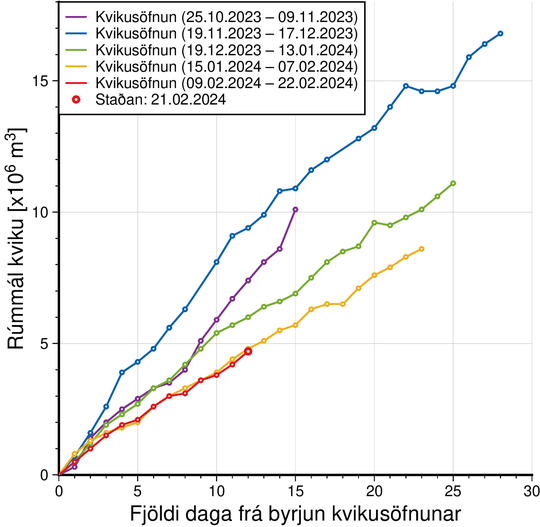
Model calculations show that around 5 million cubic meters of magma have now accumulated under Svartsengi. If you look at the eve of previous volcanic eruptions in the Sundhnúks crater series, the probability of an eruption increases when the volume has reached 8 – 13 million cubic meters. Based on the results of model calculations, it will be reached next week if the magma accumulation continues at the same rate.
It should be noted that uncertainty must be assumed in this interpretation and it cannot be stated that the development will be the same as before the last eruptions. There is also the possibility that magma will flow from Svartsengi to the Sundhnúks crater series without an eruption.
 The graph shows a comparison of the amount of magma that has accumulated under Svartsengi before the magma flows into the Sundhnúks crater sequence. The quantity is obtained by model calculations based on GPS data and is subject to uncertainty. Variations can also be seen between days. The position of magma collection on February 21 is marked in red. The purple line shows the amount of magma that accumulated before the large magma tunnel under Grindavík formed on November 10.
Eruption warning may be very short
It is still the opinion of scientists that if there is an eruption, it is most likely that the magma will move from Svartsengi to the Sundhnúksgíga series and that an eruption will occur in the area between Stóra-Scógfell and Hagafell. Signs that magma is making its way to the surface would appear in sudden, localized and intense micro-seismic activity. If you look at previous eruptions in the area, a new eruption could start with very little notice, less than 30 minutes, depending on where in the Sundhnúks crater series magma emerges.
Likely scenarios
Eruption between Sýlingarfell and Stóra-Skógfell – Similar to December 18, 2023 and February 8, 2024
- Prelude: Sudden, localized and intense microseismic activity. Deformation across the magma tunnel.
- Very short notice (less than 30 minutes) as magma has an easy way to the surface due to previous upheavals.
- Lava reaches Grindavíkurvegi in less than 4 hours.
Eruption at Hagafell – Similar to January 14, 2024
- Prelude: Small seismic activity in the Sundhnúks crater series that starts at Sýlingarfell and moves south. Deformation across the magma tunnel.
- Probably 1 – 3 hours notice. from when the first earthquakes are measured and the eruption begins.
- Lava reaches the defenses at Grindavík in 1 hour.
- A magma intrusion extending south of Hagafell will probably cause significant fissure movements in Grindavík.
Eruption within the fortifications at Grindavík
- Prelude: Small seismic activity in the Sundhnúks crater series that starts at Sýlingarfell and moves south. Deformation across the magma tunnel.
- Probable notice of 1 – 5 hours. from when the first earthquakes are measured and the eruption begins.
- There is a possibility that a fissure opens within the defense walls without an eruption having started at Hagafell, as happened on January 14 when a new fissure opened right at the town border about 4 hours after the eruption started at Hagafell.
- A magma intrusion extending south of Hagafell will probably cause significant fissure movements in Grindavík.
The fact that there are now clear signs of landris in Svartsengi does not mean that there is the most likely place for the source of the eruption. It is estimated, among other things, from the fact that the earth's crust above the magma tunnel at the Sundhnúks crater is much weaker than the earth's crust above the land giant in Svartsengi. If the scenario becomes a reality that the magma will go straight up into Svartsengi, it is estimated that it will take the magma at least 4 – 7 hours. to reach the surface from the first sign of such a thing begins to be measured.
It should be noted that the scenarios are based on the interpretation of the latest data and the scenario that has been recorded in previous volcanic eruptions in the Sundhnúks crater series. Uncertainty must be assumed in this interpretation, since only a few events are involved.
Weather conditions may affect monitoring and evacuations
It should be noted that although the Norwegian Meteorological Agency has not increased the danger level in the upheaval areas at this stage, conditions there can change very quickly and without warning. This applies to all natural hazards that the Norwegian Meteorological Agency monitors, and those who have business in the danger areas need to be aware of this.
The effectiveness of the Norwegian Meteorological Agency's monitoring depends on the good sensitivity of earthquake and real-time GPS measurements, but the sensitivity is highly dependent on weather conditions. High wind and surf affect the low frequency in the turbulence measurements where waves appear as turbulence. Fog and dark clouds then affect the visual confirmation of eruptions with cameras.
The risk assessment issued by the Norwegian Meteorological Agency does not take into account weather conditions or other factors that may affect the risk of being in danger zones.


/frimg/1/47/9/1470957.jpg)


