My thoughts remain the same for the most part. The only thing that has changed is that I now believe we have greater potential to see this end up on the stronger side of the intensity forecast, and wouldn't rule out major status.
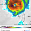
Above: major-hurricane landfalls between St. Marks and Crystal River, Florida, between 1851 and 2022. Map is centred on Horseshoe Beach, with a 60-n-mi radius.
Since 1851 only a handful of major hurricanes have made landfall on Florida’s Big Bend, between St. Marks and Anclote Key: one each in 1896 and 1950 (Hurricane Easy), officially. Both storms were Category-3s, on the order of 105–110 knots (120–125 mph)/~960 mb.
The strongest of these two was the 1896 Cedar Keys hurricane, which, though officially 110 knots (125 mph)/~960 mb at landfall, by all accounts was likely much stronger. Of the roughly 115 deaths in Florida, roughly forty-five occurred on the Cedar Keys, meaning that more than 60% of the fatalities occurred inland and thus were due to wind,
not flooding or storm surge. Historical accounts indicate that miles of forested land across the interior of North Florida were left without a single tree standing. Also, the storm produced a surge of 12.6’ at Yankeetown, which was outside the swath of strongest winds, so the actual surge between Cedar Keys and that location was likely ~15–20’, given the small size, rapid speed, and extreme intensity of the storm. So the hurricane of 1896 was likely a strong Category 4+ at landfall, like Charley (2004), but was not officially recorded as such, owing to sparseness of meteorological instrumentation.
Another storm that was likely of major intensity at landfall was the 1935 Labor Day hurricane. This storm was and is the strongest to make landfall on the mainland United States, based on its intensity in the Florida Keys...which was officially 160 knots (185 mph) but likely on the order of 175 knots (200 mph), based on contemporaneous surveys, along with a measured central pressure of 892 mb. At landfall on the Big Bend, the storm was officially a low-end Category-2, with winds of 85 knots (100 mph). However, cities well inland from the coast, including Madison, Florida, and Valdosta, Georgia, reported pressures of 972–9 mb...the former being a peripheral reading. Given the storm’s compact size, these readings would likely support major-hurricane status at the coastline. Additionally, despite being outside the swath of peak winds, Cedar Key registered its highest storm tide since the hurricane of 1896. So the ‘35 hurricane was likely still a Category-3+ at landfall.
Prior to 1851, there were a number of major storms that affected the region, including one in 1842 that generated a 20’ surge on the Cedar Keys, along with the Great Havana–Key West hurricane of 1846.