• Welcome to TalkWeather!
    We see you lurking around TalkWeather! Take the extra step and join us today to view attachments, see less ads and maybe even join the discussion.
    CLICK TO JOIN TALKWEATHER
  • April 2024 Weather Video of the Month
    Post your nominations now!

Hurricane Hurricane IDALIA: threat to the northeastern Gulf Coast

Messages
535
Reaction score
475
Location
Northern Europe
Most of the strongest members of the EC suite, along with the HAFS-A/-B and HWRF, suggest a landfall between St. Vincent Island and New Port Richey, with “ground zero” likely being between St. Marks and Cedar Key. The first package from the National Hurricane Centre (21Z/today) shows a rapidly-deepening 65-kt system well offshore prior to landfall, so the forecast likely implies either a high-end Category-1 or low-end Category-2 over Apalachee Bay. Obviously future packages are likely to reflect significant upward adjustments intensity-wise. Lunar phase notwithstanding, the forecast does show a very rapid acceleration offshore, which, along with a smaller-than-average wind-field, would potentially offset the surge somewhat. Remember: Charley (2004) rapidly deepened into a borderline-Category-5 hurricane prior to landfall, yet barely produced any surge, owing to its tiny size and quick movement. Current satellite-imagery also suggests that Idalia is going to be a tightly-organised, rapidly-intensifying system, embedded in high environmental pressures. So a fast forward speed and small size in this case would reduce rainfall and surge, possibly significantly, regardless of intensity.

One thing is rather clear: Tampa Bay’s notorious, if fictitious, “hurricane-shield” is almost certainly going to be at work once more.
 
Messages
535
Reaction score
475
Location
Northern Europe
1969-Camille-RH-1.gif

1969-Camille-RH-2.gif


^ As the vectors illustrate, dry, continental, montane air in the vicinity of Camille’s western quadrant was being pushed away from the storm. Eloise and Michael:

1975-Eloise-H7-1.gif

2018-Michael-H7-1.gif


^ To a lesser degree than in Camille’s case, certainly, but also reminiscent. Eloise especially is striking, with virtually no westerly flow nearby.

By contrast...

ecmwf-mid-RH-watl-29.png


...models such as the ECMWF suggest that Idalia may ingest substantial amounts of stable air from the northwest. This is a big difference.

Do I think that Idalia could overcome this environment and deepen down into the 930s mb or even lower? Certainly. But winds may not mix as efficiently.
 

JBishopwx

Member
Sustaining Member
Messages
938
Reaction score
2,134
Location
Ackerman, MS
Special Affiliations
  1. SKYWARN® Volunteer

akt1985

Member
Messages
1,030
Reaction score
552
Location
Madison, Alabama
Are the chances this system becomes a major hurricane still small? If future Idalia landfalls in Taylor or Dixie County at Category 3 or higher, it would be worse than the No Name Storm associated with the Blizzard of 1993.
 

JPWX

Member
Messages
1,585
Reaction score
4,313
Location
Smithville MS
Are the chances this system becomes a major hurricane still small? If future Idalia landfalls in Taylor or Dixie County at Category 3 or higher, it would be worse than the No Name Storm associated with the Blizzard of 1993.
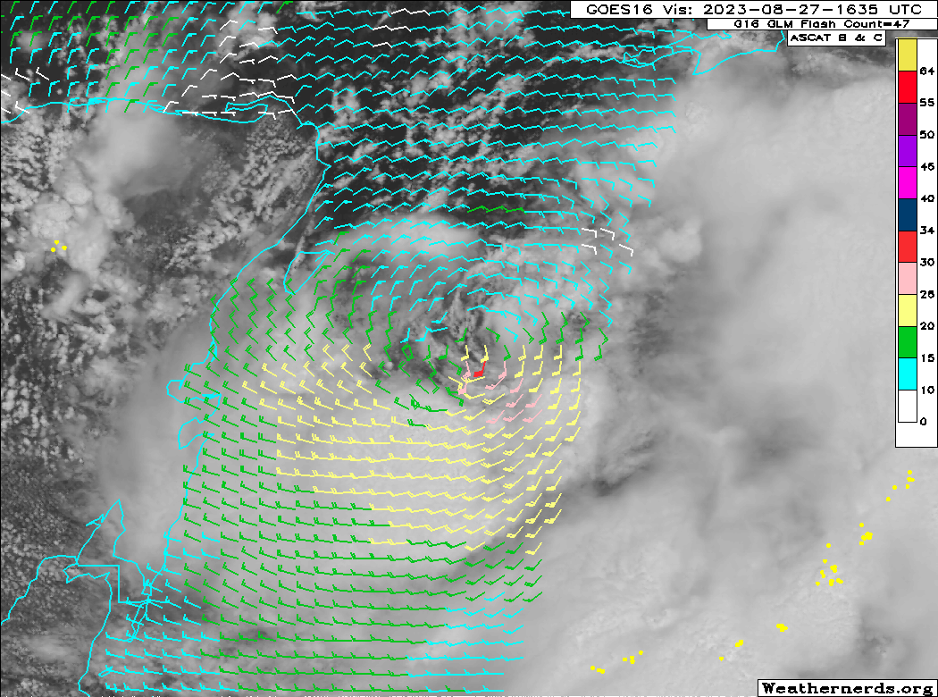
I personally would say no to that. The warmth of the Gulf plus other aspects going forward suggest that TD Ten becomes a hurricane rather quickly.
 

Clancy

Member
Messages
3,129
Reaction score
5,838
Location
Macland, Georgia
8AM update: TD10 continuing to organize, will likely become a TS today. Path remains pretty much the same from last night.
 
Messages
535
Reaction score
475
Location
Northern Europe
Based on satellite the low-level centre appears to be pivoting eastward, well offshore of Cozumel. This trend matches the 06Z EPS cycle’s well. Notably, the system appears to be suffering from dry-air intrusion and northeasterly mid-level shear, ensconced as it is in a region between an upper-level anticyclone and Franklin’s circulation. This may well result in a much weaker system over the Gulf of Mexico, prior to landfall in Florida. Notably, the weakest EPS members are also the farthest east in terms of landfall, some of which show landfall as far south as New Port Richey, just north of Greater Tampa Bay. The HAFS-A/-B and HWRF have also trended toward a much weaker peak and now show landfall considerably farther east than previous runs did.
 

Taylor Campbell

Moderator
Moderator
PerryW Project Supporter
Messages
2,138
Reaction score
2,242
Location
Wedowee, AL
Special Affiliations
  1. SKYWARN® Volunteer
06z GFS with rapid intensification from 7pm Tuesday at 986mb to 960mb at 9am Wednesday (26mb drop in 14hrs).
 
Last edited:

Taylor Campbell

Moderator
Moderator
PerryW Project Supporter
Messages
2,138
Reaction score
2,242
Location
Wedowee, AL
Special Affiliations
  1. SKYWARN® Volunteer
Tropical Depression Ten Discussion Number 4
NWS National Hurricane Center Miami FL AL102023
1000 AM CDT Sun Aug 27 2023

So far this morning, the overall cloud pattern of the tropical
cyclone has not become significantly better organized. The small
center is partially exposed on GOES-16 visible imagery, and
convective banding features are still not very well defined. The
current intensity is held at 30 kt for this advisory which is in
line with the latest Dvorak Satellite estimates. A NOAA Hurricane
Hunter aircraft, flying at around 12000 ft, is near the center of
the system taking Doppler radar wind velocity measurements. These
data should provide valuable information on the structure of the
cyclone for initializing the numerical weather prediction models.

The center of the cyclone appears to have been moving in a small
clockwise loop overnight and into this morning, and it will
probably complete this loop today. The initial motion estimate is
now around 090/2 kt. Steering currents should remain weak through
today and tonight. Beginning on Monday, a mid-level ridge starts to
build near southern Florida and eastward. This evolution should
cause a generally northward motion during the next couple of days.
In 48 to 72 hours, a mid-level trough dropping into the eastern U.S.
will likely induce a turn toward the north-northeast and take the
system across the northeast Gulf of Mexico coast on Wednesday. The
official forecast track has been nudged to the right of the
previous one, but is not quite as far east as the latest corrected
consensus, HCCA, prediction. Users are reminded not to focus on
the exact forecast track, since strong winds, heavy rains and
dangerous storm surges extend well away from the center.

The cyclone will be moving over waters of high oceanic heat content
over the eastern Gulf of Mexico and within a moist mid- to
low-level air mass for the next few days. An upper-tropospheric
trough is predicted to develop over the western Gulf of Mexico in 48
to 72 hours. Although this feature could produce some moderate
southwesterly vertical wind shear over the system, positive
vorticity advection and diffluent upper-level flow to the east of
the trough will likely be conducive for strengthening. The
official forecast, like the previous one, calls for the cyclone to
reach hurricane status over the eastern Gulf of Mexico in 48 to 72
hours. This is at the high end of the latest intensity model
guidance.
 
Messages
535
Reaction score
475
Location
Northern Europe
SgWzx.png


I don’t think that this is a tropical storm yet. This pass from ASCAT only shows winds of < 34 knots throughout the circulation, notwithstanding reconnaissance.
 
Back
Top