tornado examiner
Member
Erin’s eye still hasn’t fully eroded away on IR
Follow along with the video below to see how to install our site as a web app on your home screen.
Note: This feature may not be available in some browsers.
I'm not totally sure, but you're right, it is taking a long time. The radar and recon don't show a new eye wall taking over that I can tell, so it might indeed be failing.What is with this EWRC taking this long? Is it actually failing somehow?
Satellite and Doppler Radar data from San Juan indicate that Erin is going through some notable structural changes. The hurricane still has a small eye in radar images with a tight and closed eyewall. Beyond the small core, there are numerous convective rainbands that are expanding in all quadrants, with some indication of an outer eyewall beginning to take shape. Data from the Air Force Hurricane Hunters a few hours ago indicated that the peak winds have been decreasing, and the initial intensity is set at 110 kt using a blend of the latest satellite estimates. The outer bands to the south of the center are still affecting portions of the Virgin Islands, Puerto Rico, and the Dominican Republic. These bands are producing gusty winds and locally heavy rains. The Air Force and NOAA Hurricane Hunters are scheduled to investigate Erin again later this morning, and their data will provide a better assessment of the hurricane's intensity and structure.
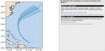
Erin has been wobbling around, but it appears to be moving a little to the south of the previous track. The hurricane is still moving west-northwestward at 12 kt on the south side of a subtropical ridge. This ridge is expected to break down later today due to a series of troughs moving across the northwestern Atlantic. In response to the pattern change, Erin should gradually turn toward the north and eventually the northeast. This motion should take the core of Erin to the east of the Bahamas on Monday and then roughly midway between Bermuda and the east coast of the U.S. around the middle of the week. The NHC track forecast has been nudged to the west in the short term based on the initial motion and latest model guidance.
The quick weakening over the past 6 to 12 hours is associated with Erin's structural changes and not environmental conditions. Since the large-scale environment is expected to be favorable for about another day, re-strengthening is possible during that time period. However, it should be noted that predicting the intensity evolution from internal dynamics are challenging, and models often provide little reliability in their solutions. Beyond 24 to 36 hours, a broadening of the wind field and some increase in shear should cause a gradual decay in the peak winds. Regardless of the details, there is high confidence that Erin will remain a powerful hurricane during the next several days.
Erin is growing in size, and that trend is expected to continue over the next few days. The expanding wind field will result in rough ocean conditions over much of the western Atlantic. Given the track adjustments and increasing size, the government of the Bahamas has issued a Tropical Storm Warning for the Turks and Caicos Islands and a Tropical Storm Watch for the Southeast Bahamas.
