tornado examiner
Member
Oh yeah rapid intensification is underway. Right now.
Follow along with the video below to see how to install our site as a web app on your home screen.
Note: This feature may not be available in some browsers.

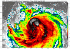
No clue. The eye actually looks somewhat like a rectangle.View attachment 46145
gah damn, that looks insane, but what is the eye doing


Deep convection has been increasing in intensity and symmetry, and it seems likely that Erin will strengthen today. The intensification is likely to end by tonight due to some increase in shear and a broadening of the inner core wind field. Slow weakening seems likely beginning Tuesday, but it should be emphasized that Erin is expected to remain a powerful hurricane through the week. The NHC intensity forecast is above the models in the short term, but falls near the middle of the guidance after that.
Based on an evaluation of storm sizes of major hurricanes over the past couple of decades in the subtropics, Erin is around the 80th percentile. Erin's wind field is expected to keep growing over the next few days. The expanding wind field will result in rough ocean conditions over much of the western Atlantic. It should be noted that the 34- and 50-kt wind speed probabilities beyond 36 hours in the text and graphical products are likely underestimating the risk of those winds occurring. This is because the forecast wind field of Erin is considerably larger than average compared to the wind field used to derive the wind speed probability product.


 weather.cod.edu
Yeah, think those evacuations were the right call. Coastal flooding is easy to underestimate but as dangerous as any other flooding hazard.The storm WILL remain offshore, but indirect impacts to the Outer Banks are likely as the storm is growing huge.
View attachment 46148


Freebasing dry air + increasing shear will do that to one.Erin’s no longer beautiful.