Navigation
Install the app
How to install the app on iOS
Follow along with the video below to see how to install our site as a web app on your home screen.
Note: This feature may not be available in some browsers.
More options
-
Welcome to TalkWeather! We see you lurking around TalkWeather! Take the extra step and join us today to view attachments, see less ads and maybe even join the discussion. CLICK TO JOIN TALKWEATHER
You are using an out of date browser. It may not display this or other websites correctly.
You should upgrade or use an alternative browser.
You should upgrade or use an alternative browser.
Hurricane Erin
- Thread starter wx_guy
- Start date
KakashiHatake2000
Member
yeah i think it could remain a possibility that is with i believe seeing a post on that on x say maybe matthew cappucci or wtus or somewhere but dont take my word for itIs it a likelyhood for it to regain cat 5 intensity after the EWRC? I guess it could but it won’t reach its peak again.
KakashiHatake2000
Member
i know right it is pretty neat seeing photos and also videos on the eye of a hurricane
Kds86z
Member
Yessir broi know right it is pretty neat seeing photos and also videos on the eye of a hurricane
Central Ohio Wx
Member
KakashiHatake2000
Member
KakashiHatake2000
Member
yepYessir bro
tornado examiner
Member
Recon is in. An hour too late
- Thread starter
- #249
wx_guy
Member
- Messages
- 1,202
- Reaction score
- 4,315
- Location
- United States
- HAM Callsign
- KO4ZGH
- Special Affiliations
- SKYWARN® Volunteer
- ARRL Member
Is it just me or is the HAFS-A and HAFS-B 18z running late today. Curious what they show...
- Thread starter
- #250
wx_guy
Member
- Messages
- 1,202
- Reaction score
- 4,315
- Location
- United States
- HAM Callsign
- KO4ZGH
- Special Affiliations
- SKYWARN® Volunteer
- ARRL Member
Looks like perhaps Erin is down to a 145-150 mph Cat 4 with pressure around 930 mb. Two recon planes have sampled nearly the same thing. Looks like an eye wall replacement cycle is ongoing. It should have time for a second peak later tonight or in the morning/tomorrow.
majorhurricane1703
Member
I don’t think this is going to weaken like the models think. Being that it is so large it will weaken maybe due to eye wall replacements cycles but not because of other factors until it reaches the North Atlantic. I think it will come back stronger after the new eyewall contracts.
- Thread starter
- #252
wx_guy
Member
- Messages
- 1,202
- Reaction score
- 4,315
- Location
- United States
- HAM Callsign
- KO4ZGH
- Special Affiliations
- SKYWARN® Volunteer
- ARRL Member
Indeed, 8 PM advisory has it at 150 mph and 934 mb. Says it's moving due west and still hugging 20 N.Looks like perhaps Erin is down to a 145-150 mph Cat 4 with pressure around 930 mb. Two recon planes have sampled nearly the same thing. Looks like an eye wall replacement cycle is ongoing. It should have time for a second peak later tonight or in the morning/tomorrow.
tornado examiner
Member
Erin is officially back at C4 150mph.
majorhurricane1703
Member
Indeed, 8 PM advisory has it at 150 mph and 934 mb. Says it's moving due west and still hugging 20 N.
Erin is definitely being stubborn to go on any consistent west northwest track as it is clearly moving west now. Will only need to take another 1-2 shifts with the Euro expanding the high west and the trough receding for it to bring this dangerously close if not over the northeast. I think North Carolina is safe, but what happens after the mid latitudes is a more complex setup that I don’t think the models are prepared for yet. What makes this maybe different than other years is the North Atlantic is warmer than the south, which is likely not as common for model data put into the computers. Makes me wonder if unusual things could occur even though chances are they won’t.
- Thread starter
- #255
wx_guy
Member
- Messages
- 1,202
- Reaction score
- 4,315
- Location
- United States
- HAM Callsign
- KO4ZGH
- Special Affiliations
- SKYWARN® Volunteer
- ARRL Member
notsoencrypted
Member
Northeastern Puerto Rico now has flash flood warnings and a severe thunderstorm warning as one of the bands moves on shore, as well as a flood watch. I really hope this thing turns more north soon.
Edit: The US Virgin Islands are also under similar warnings and watches.
Edit: The US Virgin Islands are also under similar warnings and watches.
- Thread starter
- #257
wx_guy
Member
- Messages
- 1,202
- Reaction score
- 4,315
- Location
- United States
- HAM Callsign
- KO4ZGH
- Special Affiliations
- SKYWARN® Volunteer
- ARRL Member
Okay, the 0z Best Track info is in, and here's the latest results from my tool...
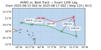
First up, the GFS error the past 5 days:
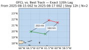
And the Official forecast error the past 5 days:
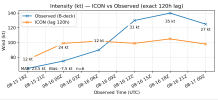
Fun story, the ICON has actually done better on intensity than the Official forecast:
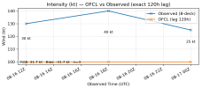
Versus the Official 5-day error on intensity:
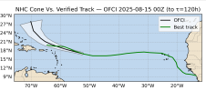
The Cone error 2 days ago at this time versus actual track:
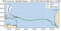
The Cone from last night:
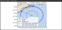
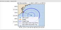
Using the 5-year historical error percentiles, it looks exceedingly unlikely that the Outer Banks are at risk, with the error needing to be in about the 96th percentile of errors, deviating from the forecast point by about 340 nautical miles to the West. Not impossible, but very, very unlikely.
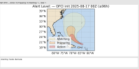
For Alert levels, Bermuda still needs to watch trends, and the Outer Banks is close to the watching trends also. This is for 4 days out.
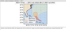
For 5 days out, Nova Scotia and New England also need to watch trends. New England it's very unlikely also, but not impossible. Nova Scotia it's a little more likely.
First up, the GFS error the past 5 days:

And the Official forecast error the past 5 days:

Fun story, the ICON has actually done better on intensity than the Official forecast:

Versus the Official 5-day error on intensity:

The Cone error 2 days ago at this time versus actual track:

The Cone from last night:

Using the 5-year historical error percentiles, it looks exceedingly unlikely that the Outer Banks are at risk, with the error needing to be in about the 96th percentile of errors, deviating from the forecast point by about 340 nautical miles to the West. Not impossible, but very, very unlikely.

For Alert levels, Bermuda still needs to watch trends, and the Outer Banks is close to the watching trends also. This is for 4 days out.

For 5 days out, Nova Scotia and New England also need to watch trends. New England it's very unlikely also, but not impossible. Nova Scotia it's a little more likely.

- Thread starter
- #258
wx_guy
Member
- Messages
- 1,202
- Reaction score
- 4,315
- Location
- United States
- HAM Callsign
- KO4ZGH
- Special Affiliations
- SKYWARN® Volunteer
- ARRL Member
Looks like it's resumed its northward component to its movement finally. At about 20.2 N now.
majorhurricane1703
Member
Okay, the 0z Best Track info is in, and here's the latest results from my tool...
First up, the GFS error the past 5 days:
View attachment 46122
And the Official forecast error the past 5 days:
View attachment 46123
Fun story, the ICON has actually done better on intensity than the Official forecast:
View attachment 46124
Versus the Official 5-day error on intensity:
View attachment 46125
The Cone error 2 days ago at this time versus actual track:
View attachment 46126
The Cone from last night:
View attachment 46127
Using the 5-year historical error percentiles, it looks exceedingly unlikely that the Outer Banks are at risk, with the error needing to be in about the 96th percentile of errors, deviating from the forecast point by about 340 nautical miles to the West. Not impossible, but very, very unlikely.
View attachment 46128
For Alert levels, Bermuda still needs to watch trends, and the Outer Banks is close to the watching trends also. This is for 4 days out.
View attachment 46129
For 5 days out, Nova Scotia and New England also need to watch trends. New England it's very unlikely also, but not impossible. Nova Scotia it's a little more likely.
View attachment 46130
I agree with everything you said. There’s one wrinkle that I think you can throw out whatever the percentages for the northeast are currently at the moment. If it comes north as let’s say as a huge large sized 930 millibar hurricane in the mid Atlantic part of the ocean well there’s very very little historical data to draw from such a storm with models. That intensity would matter at that latitude because a broader 930 millibar hurricane’s expanded outflow can more easily reinforce the bottom of the ridge to the very north making it more resistant to a trough eroding it depending on the intensity of the trough. There’s cases of strong hurricanes in the North Atlantic but not a large sample of data for one as intense (like 930 millibars) and also big in size. That’s why it’s harder to put a real percentage on this even though I agree it is very very low at the moment from an overall likelihood.
- Thread starter
- #260
wx_guy
Member
- Messages
- 1,202
- Reaction score
- 4,315
- Location
- United States
- HAM Callsign
- KO4ZGH
- Special Affiliations
- SKYWARN® Volunteer
- ARRL Member
I agree with everything you said. There’s one wrinkle that I think you can throw out whatever the percentages for the northeast are currently at the moment. If it comes north as let’s say as a huge large sized 930 millibar hurricane in the mid Atlantic part of the ocean well there’s very very little historical data to draw from such a storm with models. That intensity would matter at that latitude because a broader 930 millibar hurricane’s expanded outflow can more easily reinforce the bottom of the ridge to the very north making it more resistant to a trough eroding it depending on the intensity of the trough. There’s cases of strong hurricanes in the North Atlantic but not a large sample of data for one as intense (like 930 millibars) and also big in size. That’s why it’s harder to put a real percentage on this even though I agree it is very very low at the moment from an overall likelihood.
Sure! Depending on the part of the New England area, it's between the 90th and 95th percentiles error for the *center* to hit those areas. It's much more likely to sideswipe those areas, especially if it's a huge storm in size. If it follows the forecast point exactly, it'd be about 425 nautical miles away from the Northeast coast.
