
Navigation
Install the app
How to install the app on iOS
Follow along with the video below to see how to install our site as a web app on your home screen.
Note: This feature may not be available in some browsers.
More options
-
Welcome to TalkWeather! We see you lurking around TalkWeather! Take the extra step and join us today to view attachments, see less ads and maybe even join the discussion. CLICK TO JOIN TALKWEATHER
You are using an out of date browser. It may not display this or other websites correctly.
You should upgrade or use an alternative browser.
You should upgrade or use an alternative browser.
Hurricane Hurricane Dorian
- Thread starter Taylor Campbell
- Start date
DaveFromGA
Member
warneagle
Member
No words.
warneagle
Member
These numbers are just crazy.
- Staff
- #385
Even Timmer is trying to contact him!! 
- Staff
- #387
On Facebook this is a public site, it gives updates but some of it is heartbreaking to read!!
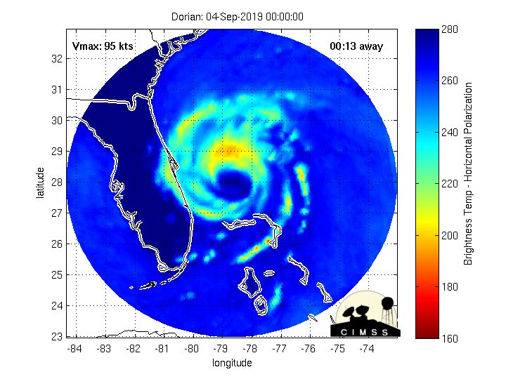
Radar presentation seems to be improving, with the inner eye almost gone and the larger outer eye possibly taking over. Satellite still shows a lot of dry air near the core though, so hopefully that'll continue to be a limiting factor.
Aaand 20 minutes later, it just looks like a ragged inner eye on radar with a lot of dry air issues.
Kory
Member
Morning sounding out of Miami has a 5% relative humidity value at 250mb.Aaand 20 minutes later, it just looks like a ragged inner eye on radar with a lot of dry air issues.
DaveFromGA
Member
Evan
Member
Aaand 20 minutes later, it just looks like a ragged inner eye on radar with a lot of dry air issues.
Large chunk of his northern side has been disrupted by a big slug of dry air. Probably the only thing that was keeping from re-organizing. Recon shows pressure is up another few mb. Very hopeful it takes him awhile to deal with the dry air and it causes further issues with his structure and attempts to re-organize.
- Staff
- #392


DaveFromGA
Member
Great news he is alive, imagine he probably has some amazing video as it was happening.
Evan
Member
Dorian has really gotten his act together over the past few hours. If he can finish just a bit more re-organization he may be able to tap into 12-24 hours of favorable conditions and intensify. I wouldn't expect considerable intensification, but I think he could get his pressure back down to the 940s.
Kory
Member
I think storm structure will preclude any large scale strengthening. We may see some small pressure drops but the wind field is so expansive I don’t think winds will respond appropriately. It’s quite lopsided per microwave scans.
I think storm structure will preclude any large scale strengthening. We may see some small pressure drops but the wind field is so expansive I don’t think winds will respond appropriately. It’s quite lopsided per microwave scans.
Agree to an extent, but it is trying to get better organized on satellite and you can see that a bit as well on the latest microwave scans.
Evan
Member
I think storm structure will preclude any large scale strengthening. We may see some small pressure drops but the wind field is so expansive I don’t think winds will respond appropriately. It’s quite lopsided per microwave scans.
I agree with that, and that's why I was focused solely on pressure. Since he's gotten larger, a 10-12mb drop might only see the winds slightly improve or even remain about the same. But it will only take a small pressure fall to get back to 949 or below. Several tropical intensity models have forecasted this kind of improvement off-and-on and it seems to be very dependent upon Dorian getting himself re-organized. I think he's close to having done that, and if he continues to improve I believe modest pressure drops are quite possible.
Kory
Member
Rather underwhelming wind reports from the coastline in Florida. Most are seeing very low end tropical storm gusts. Probably need some convection to get higher winds down to the surface.
Kory
Member
The *majority* of Florida has dodged yet another bullet (I say this because Michael certainty wasn't a dodged bullet, but the relative disaster impacts to populated areas were quite limited compared to the density of Central and South Florida).
Coastal parts of the Carolinas will definitely be dealing with a solid hurricane as landfall somewhere on the Outer Banks looks very likely, but we should avoid a major hurricane landfall.
Coastal parts of the Carolinas will definitely be dealing with a solid hurricane as landfall somewhere on the Outer Banks looks very likely, but we should avoid a major hurricane landfall.