TornadoFan
Member
Tornado emergency for Alexandria.
Follow along with the video below to see how to install our site as a web app on your home screen.
Note: This feature may not be available in some browsers.

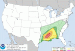
Mesoscale Discussion 2207
NWS Storm Prediction Center Norman OK
1239 PM CST Mon Dec 16 2019
Areas affected...northern Rapides Parish in central Louisiana
Concerning...Tornado Watch
700...
Valid 161839Z - 161915Z
The severe weather threat for Tornado Watch 700 continues.
SUMMARY...Based on recent radar and environmental data, a strong to
potentially intense tornado with potential peak winds of 110 to 155
mph (EF1-EF3) is likely ongoing and tracking towards Alexandria, LA.
DISCUSSION...Recent radar signatures from KPOE as of 1832z reveal a
long track tornadic supercell characterized by a 0.5 degree
rotational velocity between 61 and 70 kt. A tornadic debris
signature has also been noted on recent radar scans. These
signatures are occurring in an environment characterized by STP
between 4 and 5. Previous signatures within similar environments
produced tornado-damage-estimated wind speeds from 110 to 155 mph
and confidence is high for likely strong to potentially intense
tornado. A tornado is ongoing and may continue based on the
rotational velocity continuity and the storm moving within a
favorable downstream environment.
From the Port Gibson, MS storm earlier - Anyone know who the chaser is?


FWIW, new NAM run, 00z near Columbus MS... might have an issue with lots of tornadoes in a QLCS, but NAM remains way more aggressive than many other models
View attachment 2188