• Looks like our DeLorean hit 88 miles per hour a little too hard! A recent style update went sideways, sending us back to a retro look for a bit. We've parked that faulty future theme for now while we tinker under the hood.
  • Welcome to TalkWeather!
    We see you lurking around TalkWeather! Take the extra step and join us today to view attachments, see less ads and maybe even join the discussion.
    CLICK TO JOIN TALKWEATHER

Severe WX December 16-17 2019 Severe Weather Outbreak

JayF

Technical Administrator
Staff member
Administrator
Moderator
Technical Admin
Sustaining Member
Messages
1,656
Location
Hartselle, al
HAM Callsign
KB4JCS
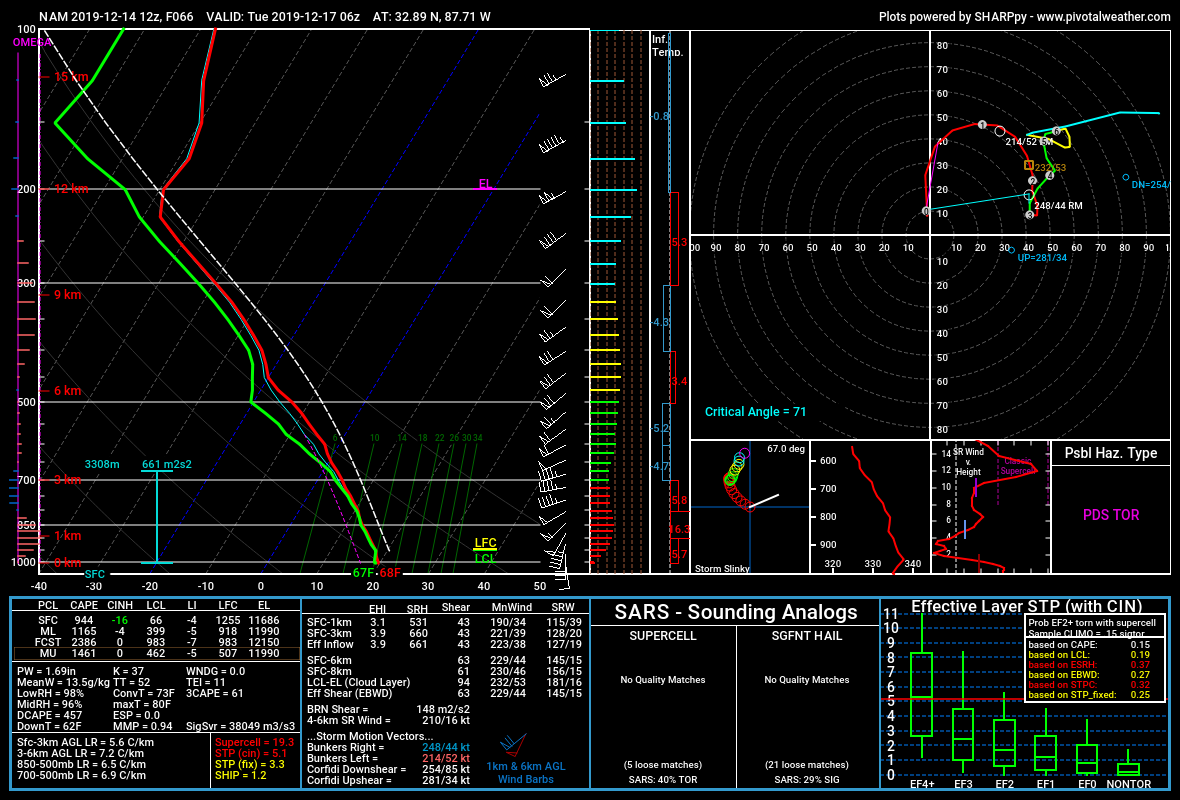
Looking at the model data I am thinking that NE Mississippi, Central to North Alabama and Southern Middle Tennessee are the highest chances for severe weather come Monday. IF the models are correct and I realize we are 5 days out, the Chattanooga area is going to be hardest hit. Let's discuss the upcoming weather pattern.
 
I hope not. People are so busy with holiday stuff right now and we haven't had an event in a while, so some may have let their guard down.
 
Wasn’t December 16th also the same date as the south Tuscaloosa tornado back in 2000?


You would be correct. Unfortunately with it now being 4 days out, the NWS has increased the 15% area.

Alabama is second only to Texas with 39 Christmas week (December 23-27) tornadoes since 1950. The strongest Alabama tornado on record in December was the Tuscaloosa F4 on 12/16/2000. This tornado was responsible for 11 fatalities and 144 injuries. This tornado was caught live on a tower camera during James Spann’s coverage.

This is the link where that information came from.

 
To me, it looks like the timing isn't right as far as the dynamics and instability.
Yeah the window where the best shear and best instability overlap is pretty small (not to mention some potential VBV that’s evident on some of the forecast soundings and storm mode issues).
 
We're in NAM range now 84h out, and getting a sliver of overlap as the best shear moves out that it still looks like we could briefly have some issues. Biggest threat here so far this fall season though I think.
 
Admin Note: I edited the title so it would be easier to search down the road.
 
18Z NAM still pretty spicy for central AL, though VBV still present
nam_2019121318_075_33.31-87.42.png
 
I guess we get to see in the short term how much instability we DO manage to get, always a big question in these events
 
I’m not sure we’ll have enough forcing to get any convection across the open warm sector. We’ll be relying on the cold front to spark convection and I’m not sure that will lead to a more significant threat.
 
Probably contaminated, but NAM still pretty hyped up; always fun to play the classic find-the-PDS-TOR-sounding. SW of Tuscaloosa

nam_2019121412_066_32.89-87.71.png
 
Probably contaminated, but NAM still pretty hyped up; always fun to play the classic find-the-PDS-TOR-sounding. SW of Tuscaloosa

nam_2019121412_066_32.89-87.71.png
The NAM is also a bit slower than the GFS...by at least a couple of hours, which give more time for instability to move northward, causing a larger and expanding warm sector...but also storm mode may be a bit messy.
 
Yeah it's increasingly a good bit off from the GFS timing-wise. GFS still not super convinced everything lines up right; very interested in seeing the CAMs/other regionals have to say as we get closer.
 
Wasn’t December 16th also the same date as the south Tuscaloosa tornado back in 2000?

I was waiting to see if anyone saw the date!!


124615A9-6595-44B4-BA7B-2D3F70D13F63.jpeg
 
I remember that one. Lived in Starkville, MS at the time. Depending on the winter, we could have tornadoes, snow, or ice storms in December.

The end of November usually signaled the beginning of severe weather season. We could go from below zero to tornadoes anytime during December, January, and February.
 
I remember watching that one live on ABC 33/40's tower cam. I *think* it was the first live tornado they caught on camera.
 
I was just ten but I remember that day clearly... and the dusting of snow immediately thereafter.
 
Back
Top