TornadoFan
Member
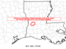
That DeRidder storm is just massive.
Follow along with the video below to see how to install our site as a web app on your home screen.
Note: This feature may not be available in some browsers.
Nothing to impede it as it gets closer to Alexandria as well....That DeRidder storm is just massive.
It’s going through a national forest so likely picking up a lot of trees.Debris ball is back on the DeRidder storm.
The HRRR has nailed this across MS and LA so far. It has some supercells out ahead in the open warm sector later this afternoon and evening.Trying to figure out if the supercells will run ahead of expanding warm sector into Alabama...lots of open space for these right now
That's what i was looking at..but it has been suggesting a messy storm mode at times, i wonder if these could be ahead of thatThe HRRR has nailed this across MS and LA so far. It has some supercells out ahead in the open warm sector later this afternoon and evening.

SUMMARY...Based on recent radar and environmental data, a strong to
potentially intense tornado with potential peak winds of 110 to 155
mph (EF1-EF3) is likely ongoing.
DISCUSSION...Recent radar signatures from KPOE and KLCH as of 17:31z
reveal an intense supercell characterized by a 0.5-0.9 degree
rotational velocity between 61 and 70 kt. A tornadic debris
signature has also been noted on recent radar scans. These
signatures are occurring in an environment characterized by STP
between 4 and 5. Previous signatures within similar environments
produced tornado-damage-estimated wind speeds from 110 to 155 mph
and confidence is high for likely strong to potentially intense
tornado. A tornado is ongoing and may continue based on the
rotational velocity continuity and the storm moving within a
favorable downstream environment.
The storm near Atlanta, LA bears watching. Looks like it’s starting to rotate.

Moving right toward Winnfield, which has about 6,000 people.They just issued a tornado warning on it.