I find FFC's discussion interesting, specifically regarding tomorrow.
374
FXUS62 KFFC 050928
AFDFFC
Area Forecast Discussion
National Weather Service Peachtree City GA
528 AM EDT Tue Apr 5 2022
...MULTIPLE ROUNDS OF SEVERE WEATHER ARE LIKELY BEGINNING TODAY
THROUGH WEDNESDAY..
.SHORT TERM /Today through Wednesday/...
Tuesday...
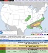
An Enhanced Risk Severe Weather Outlook has been forecast for most
of Central Georgia today with a threat for widespread damaging wind
gusts and several tornadoes possible, one or two of which may be
strong or long track. The primary threat will be this afternoon and
early evening, south of the I-20 corridor, with the highest severe
potential being along and south of a line from Columbus to Macon to
Augusta.
A strengthening low-level shortwave is currently digging across the
Lower Mississippi Valley and will continue moving eastward
throughout the day (best illustrated at 700 hPa). This shortwave
trough, with an associated low-level jet with winds over 60 kts
between 1-3 km aloft, will provide ample low-level lift throughout
the region with a weak low-pressure system being pulled across the
northern Gulf states through the day on Wednesday that will pull a
warm, moist Gulf airmass onto the forecast area throughout the
morning. Within this airmass...
* PWAT values are expected to surge well over 1.5" as dewpoints rise
to the low 60s.
* Surface-based CAPE values over 1000 J/kg, possibly as high as 2000
J/kg as afternoon highs reach the upper 60s and 70s.
* Abundant low-level shear due to the aforementioned jet manifests
as 0-1 km storm-relative helicity values between 150-400 m2/s2.
* Quarter-circled shaped hodographs from 0-1.5 km and semi-circled
hodographs from 0-6 km, storm relative inflow having
nearly 100 percent streamwise vorticity vs crosswise vorticity.
These ingredients combined are expected to create numerous severe
thunderstorms this afternoon, taking the form of a quasi-linear
convective system (QLCS) projected to kick through this afternoon
with several discrete, strong to potentially severe cells ahead of
the main line in the late morning and early afternoon. The primary
threats being severe, damaging wind gusts contained in storm
downdrafts due to 50+ kt winds at 850 hPa (1 km AGL) being
transfered to the ground and tornadoes, with high-resolution models
resolving several embedded rotating supercells within a quasi-linear
convective line. Other threats include sparse large hail and
isolated flash flooding though the messy, fast-moving storm mode
will limit these other threats. The shear speed of this system being
pushed by the forcing of the shortwave through is perhaps the only
thing preventing a larger severe weather outbreak from being
forecast.
Wednesday...
The cold pool following this line of storms won't be all that 'cool'
with generally moist adiabatic, thermodynamic profiles.
Additionally, the weak surface low-pressure will be short-lived and
won't have the ability to pull colder air behind it in the form of a
true cold front with a larger, more robust low-pressure system to
the north in the western Great Lakes region keeping the area in
broad southerly flow. The result means warm, moist air will linger
throughout the forecast area.
In Central Georgia, a coastal boundary is expected to move into the
region with a much weaker shortwave moving over the southern Gulf
states aloft. Models are predicting an unorganized cluster of storms
to develop. With PWATs increasing to near 2 inches, but shear values
being diminished in the area with a lack of stronger synoptic
forcing will limit severe potential. A Slight Risk Severe Weather
Outlook is forecast for the area as a result. The primary threat for
Central Georgia by Wednesday could be flash flooding with the
cluster of storms pushing 48-hour rainfall totals to 2.5-4 inches of
rain. Current antecedent conditions combine with the sandy Coastal
Plains soils types suggest the area may be able to handle a second
dose of heavy precip, but will need to be reevaluated after the
first round of storms moves through. Furthermore, several questions
remain about the recovery of the atmosphere after this initial wave
of storms. Strong damaging winds may also be a concern in water-
loaded downdrafts, with outside threats for large hail and very
brief spin-up tornadoes.
In North Georgia, a true cold front will push southwards into the
Northwestern corner of Georgia by dusk, with decent moisture and
instability recovery expected after the initial wave of storms on
Tuesday. A low-end Enhanced Risk Severe Weather Outlook has been
issued for the area of far north and northwest Georgia, however,
several unresolved questions still exist with this potential sever
weather setup. With relatively drier air aloft, models are
struggling to produce robust storms in the region along the frontal
zone and there is some question if convective storms further south
could rob northern Georgia of significant instability. Furthermore,
the timing of the system in the late evening could prevent storms
from being surface-based, which could prevent storms from harnessing
better ow-level wind profiles into tornadic circulations. With these
questions in mind, the primary threats will still be damaging wind
gusts with a tornado or two possible.
Thiem