- Moderator
- #21
Three days highlighted by SPC, D-4-6. For some reason can't upload them at the moment.

Follow along with the video below to see how to install our site as a web app on your home screen.
Note: This feature may not be available in some browsers.
Three days highlighted by SPC, D-4-6. For some reason can't upload them at the moment.
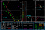
Probably, however it doesn't really matter much concerning significant tornado threat as low level shear is very meagre where instability is strongest. If this scenario was to come of, definitely a wind and hail threat would materialise but without those classic Dixie Soundings probably nothing like a significant tornado outbreak.06Z GFS shows some wicked CAPE values on the 4/06 system, at least for Dixie Alley on Wednesday. Are these overdone?
View attachment 13114

At least on 12z GFS for Wednesday, thinking the best tornado potential would be TN/KY/OH/WV, as that's where the best overlap of instability and shear is present.Probably, however it doesn't really matter much concerning significant tornado threat as low level shear is very meagre where instability is strongest. If this scenario was to come of, definitely a wind and hail threat would materialise but without those classic Dixie Soundings probably nothing like a significant tornado outbreak.
View attachment 13115
At least on 12z GFS for Wednesday, thinking the best tornado potential would be TN/KY/OH/WV, as that's where the best overlap of instability and shear is present.
Agreed, think there's some question about how far north the WF gets, GFS doesn't get it very far past Montgomery, AL still serves up a significant threat but a more limited warm sector. Euro gets it much further north to near the TN border maybe a little more southand has a pretty big warm sector but widespread convection which could limit convective organization and/or instability. NAM only goes out to 12z Tuesday on its 00z run but already has far more instability in MS/LA entering the warm sector, actually 12z NAM in itself would be a significant tornado threat in the early morning for MS/LA. Definitely needs to be watched.A very concerning synoptic setup for southern half of Alabama and Georgia on Tuesday. The current GFS almost looks March 3rd, 2019 ish.


Tuesday has now caught my eye, and things definitely look a lot more favourable for discrete supercells than past events this season, even at this range.
Per the Nam, the Warm Sector looks much more broad and unstable as well - 70F Dps quite widely even.
View attachment 13119
One concern for past 2 events was instability... here thermodynamics look pretty impressive/concerning. Tall and thick CAPE profiles modelled across S AL & MS during late Tues morning into afternoon.
View attachment 13120
Mid-level winds much less meridional, and with the larger and more unstable warm sector a partially discrete mode at least seems possible. And, while shear profiles aren't quite as extreme as last events, a 50kt LLJ will create pretty favourable hodographs anyways, though slightly offset from best intstability. Regardless, some discrete supercells, if they were to occur, could put down some strong-intense tornadoes.
View attachment 13121
To be honest, I do now feel it won't be long before one of these setups ends up with significant CAPE overlapped with significant shear with a favourable discrete mode... and resulting big problems.
Yeah, even 12z NAM is a high-end event for MS/AL/FL/GA. GFS is too progressive it seems and kinda limits the severe threat still, that may be the GFS's progressive bias however. Euro is a little closer to the NAM but does have widespread convection which could still limit the threat. However, quite a look for this far out, would expect a day 3 enhanced if this keeps up.Tuesday has now caught my eye, and things definitely look a lot more favourable for discrete supercells than past events this season, even at this range.
Per the Nam, the Warm Sector looks much more broad and unstable as well - 70F Dps quite widely even.
View attachment 13119
One concern for past 2 events was instability... here thermodynamics look pretty impressive/concerning. Tall and thick CAPE profiles modelled across S AL & MS during late Tues morning into afternoon.
View attachment 13120
Mid-level winds much less meridional, and with the larger and more unstable warm sector a partially discrete mode at least seems possible. And, while shear profiles aren't quite as extreme as last events, a 50kt LLJ will create pretty favourable hodographs anyways, though slightly offset from best intstability. Regardless, some discrete supercells, if they were to occur, could put down some strong-intense tornadoes.
View attachment 13121
To be honest, I do now feel it won't be long before one of these setups ends up with significant CAPE overlapped with significant shear with a favourable discrete mode... and resulting big problems.


...Day 4/Wednesday - Central Gulf Coast to the Central
Appalachians...
A strong mid/upper low will be located over the Upper Midwest early
Wednesday. The low and its attendant trough will develop
east/southeast across the MS Valley by Thursday morning. Intense
southwesterly midlevel flow will overspread the region as a surface
cold front surges eastward across the Ohio Valley and into the Deep
South by Wednesday evening. The cold front is expected to continue
east overnight, becoming positioned from the VA/NC Piedmont to the
central Gulf of Mexico by Thursday morning. A moist and unstable
airmass will reside ahead of the front. Strong ascent amid
boundary-parallel deep-layer flow should support linear convection
with an attendant damaging-wind and tornado threat. The northward
extent of severe potential is a bit uncertain at this time, and
severe probabilities may need to shift northward some in future
outlooks depending on forecast trends in the coming days.

When I look at the models even though this is the it's the furthest out in the forecast it looks the most troublingThe D4 is now quite large. SPC mentions linear setup with wind and tornado threat.
View attachment 13130
Doesn't seem like much shear to support major tornado business thankfully, but would still be a substantial wind threat for the Atlanta Metro.When I look at the models even though this is the it's the furthest out in the forecast it looks the most troubling
I can see Tuesday could be pretty hairy regarding tornado potential, though shear seems a lot weaker on Wednesday. Nevertheless, I usually don't like seeing CAPE modelled as high as it's supposed to be for Wednesday for GA. I'm not all that good at reading into the details beyond some of the soundings/model data, so are there some particular things that would point to Wednesday being more serious tornado-wise than currently forecast?I think these current forecast are undermining the number of tornadoes both days.