• Welcome to TalkWeather!
    We see you lurking around TalkWeather! Take the extra step and join us today to view attachments, see less ads and maybe even join the discussion.
    CLICK TO JOIN TALKWEATHER
  • April 2024 Weather Video of the Month
    Post your nominations now!
Logo 468x120

Severe WX April 4th-6th, 2022 Severe Weather Threat

Messages
2,860
Reaction score
4,670
Location
Madison, WI
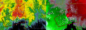
The cell south of the Ft. Deposit storm could be trouble as well.

That one also has nothing to its south, its left split looks to be raining into the inflow of the Ft. Deposit one. Sometimes in Dixie that sort of thing doesn't matter but I'm shocked I'm not seeing a TDS with how it looks otherwise.
 

keithGA

Member
Messages
189
Reaction score
327
Location
GA
Special Affiliations
  1. SKYWARN® Volunteer
New MCD out.

Mesoscale Discussion 0406
NWS Storm Prediction Center Norman OK
1015 AM CDT Tue Apr 05 2022

Areas affected...Portions of southern/central GA and the FL
Panhandle

Concerning...Severe potential...Tornado Watch likely

Valid 051515Z - 051715Z

Probability of Watch Issuance...95 percent

SUMMARY...A threat for several tornadoes and numerous damaging winds
will spread eastward this afternoon. Some of the tornadoes could be
strong. Tornado Watch issuance will be needed.

DISCUSSION...A small bowing complex with a history of producing
damaging winds and embedded tornadoes is moving eastward across
southern AL this morning. A couple of low-topped supercells are also
present ahead of the line. Recent visible satellite trends show a
fair amount of mid and high-level cloudiness downstream of this
activity across much of GA and parts of the FL Panhandle. Even so,
the airmass across this region is expected to destabilize enough to
support surface-based storms this afternoon. 15Z surface
observations show temperatures rising into the upper 60s and 70s,
with dewpoints gradually increasing into the 60s. MLCAPE should
increase into the 500-1500 J/kg range as this occurs, even though
mid-level lapse rates should remain fairly modest.

A 40-50+ kt south-southwesterly low-level jet will spread eastward
over GA this afternoon. A strongly veering and strengthening wind
profile with height through mid levels will likely support updraft
rotation both within the line and with any cells that can remain
discrete ahead of it. Given the enhanced low-level shear, a threat
for tornadoes will likely exist, especially with any supercells that
can remain at least semi-discrete. A strong tornado will remain a
possibility with favorably enhanced low-level hodographs. The bowing
line of convection should also remain capable of producing numerous
damaging winds. Based on recent radar trends, Tornado Watch issuance
across parts of southern/central GA and vicinity appears
increasingly likely by 16-17Z (12-1 PM EDT).

..Gleason/Mosier.. 04/05/2022
 

OHWX97

Member
Messages
1,087
Reaction score
1,579
Location
Maineville, Ohio
That one also has nothing to its south, its left split looks to be raining into the inflow of the Ft. Deposit one. Sometimes in Dixie that sort of thing doesn't matter but I'm shocked I'm not seeing a TDS with how it looks otherwise.
Velocity signature still seems a bit broad, but it would not take much at all for it tighten up and drop something.
 
Messages
2,860
Reaction score
4,670
Location
Madison, WI
Bow echo (warning to the west) looks to have a BWER donut hole or "tornadocane" structure from MXX radar at the moment, although the couplet doesn't look particularly impressive.
 

OHWX97

Member
Messages
1,087
Reaction score
1,579
Location
Maineville, Ohio
Uh ohhhh...can't post but on next scan it's doing that BWER thing that Cullman 4/27 and the 12/10 monster did just before they went nuts.
Was actually just thinking about how it reminded me of the supercell that produced the Rochelle, IL tornado in 2015… another monster EF4. Not saying that will be the outcome, but this thing means business.
 
Messages
2,860
Reaction score
4,670
Location
Madison, WI
Was actually just thinking about how it reminding me of the supercell that produced the Rochelle, IL in 2015… another monster EF4. Not saying that will be the outcome, but this thing means business.

Arrrrrgh most painful chase day in my life...because I targeted right and was about 20 miles from where it eventually touched down about 90 minutes later...but decided things didn't look that great and went home.
 

Jacob

Member
Messages
1,293
Reaction score
836
Location
Roy, UT
The Luverne storm is nasty, as is the one right behind it. Also pretty strong rotation over Wetumpka at the moment.
 
Back
Top