• Welcome to TalkWeather!
    We see you lurking around TalkWeather! Take the extra step and join us today to view attachments, see less ads and maybe even join the discussion.
    CLICK TO JOIN TALKWEATHER
  • April 2024 Weather Video of the Month
    Post your nominations now!
Logo 468x120

Severe WX April 3rd-5th, 2023 (South, Southeast, Ohio Valley)

TheSuckZone

Member
Messages
412
Reaction score
973
Location
Kansas
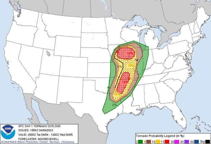
Huge hatched area on the latest day 1

Fs5UERwXwAEst7n
 

cincywx

Member
Messages
645
Reaction score
1,311
Location
Cincinnati, OH
Special Affiliations
  1. SKYWARN® Volunteer
So were there just no 18z balloon launches today? I’m not seeing anything on the SPC’s page other than DVN’s.

i was wondering the same thing. i assumed it was just taking some time to retrieve the data but its been a couple hours now so i guess DVN was the only one.
 

cincywx

Member
Messages
645
Reaction score
1,311
Location
Cincinnati, OH
Special Affiliations
  1. SKYWARN® Volunteer
very brief disco on the new d1

DAY 1 CONVECTIVE OUTLOOK
NWS STORM PREDICTION CENTER NORMAN OK
0256 PM CDT TUE APR 04 2023

VALID 042000Z - 051200Z

...THERE IS A MODERATE RISK OF SEVERE THUNDERSTORMS ACROSS PARTS OF
IOWA...WESTERN ILLINOIS...FAR SOUTHEAST OKLAHOMA AND WESTERN
ARKANSAS...

..SUMMARY

TORNADOES, SEVERE THUNDERSTORM GUSTS AND LARGE HAIL ARE LIKELY TODAY
AND TONIGHT FROM THE UPPER GREAT LAKES TO CENTRAL TEXAS. TORNADO
POTENTIAL IS FOCUSED TODAY OVER PARTS OF IOWA/ILLINOIS THIS
AFTERNOON, AND ESPECIALLY TONIGHT OVER PARTS OF THE OZARKS TO THE
ARKLATEX REGION.

..IOWA AND NORTHERN MISSOURI

THE MOST SUBSTANTIAL CHANGE FOR THIS UPDATE IS A WESTWARD EXPANSION
OF THE HIGHER TORNADO PROBABILITIES ACROSS PARTS OF CENTRAL/WESTERN
IA AND FAR NORTHERN MO. RECENT HI-RES GUIDANCE CONTINUES TO SUGGEST
A CORRIDOR OF CONVECTIVE INITIATION ACROSS NORTHWEST MO TO WESTERN
IA AROUND 22 UTC, AND THIS IDEA IS SUPPORTED BY RECENT SURFACE AND
SATELLITE OBSERVATIONS (SEE MCD #456 FOR ADDITIONAL SHORT-TERM
DETAILS). ELEVATED CONVECTION IS ALSO NOTED ACROSS NORTH TX INTO
SOUTHERN OK. THIS ACTIVITY IS EXPECTED TO INTENSIFY AS IT TRACKS
NORTHEAST THROUGH THE AFTERNOON/EVENING INTO THE HIGHER RISK
PROBABILITIES (SEE FORTHCOMING MCD #457 FOR ADDITIONAL DETAILS).

..MOORE/JEWELL.. 04/04/2023
 

warneagle

Member
Messages
4,142
Reaction score
4,327
Location
Arlington, VA
Special Affiliations
  1. SKYWARN® Volunteer
i was wondering the same thing. i assumed it was just taking some time to retrieve the data but its been a couple hours now so i guess DVN was the only one.
Which is completely unhelpful because it was on the cool side of the boundary when it was launched. Zero special launches in the warm sector of a moderate risk day is very confusing to me.
 

warneagle

Member
Messages
4,142
Reaction score
4,327
Location
Arlington, VA
Special Affiliations
  1. SKYWARN® Volunteer
Tornado warning for Howard Co., Missouri, which is, of course, about as far away from the St. Louis and Kansas City radars as you can get.
 

cincywx

Member
Messages
645
Reaction score
1,311
Location
Cincinnati, OH
Special Affiliations
  1. SKYWARN® Volunteer
Which is completely unhelpful because it was on the cool side of the boundary when it was launched. Zero special launches in the warm sector of a moderate risk day is very confusing to me.

yeah im not gonna lie, ive been mentally in denial for that exact reason. this is a complex forecast so you'd think that 18z launches would help provide some clarity. only other thing I can think of is they suspect 0z will provide a better picture.
 

warneagle

Member
Messages
4,142
Reaction score
4,327
Location
Arlington, VA
Special Affiliations
  1. SKYWARN® Volunteer
We did get a 20z sounding from SGF at least. Would’ve been nice to have something to look at from the northern MDT area but it’s better than nothing.

1680640631806.gif
 

TH2002

Member
Sustaining Member
Messages
3,818
Reaction score
6,485
Location
California, United States
Special Affiliations
  1. SKYWARN® Volunteer
Think I’m going to eat an early dinner and have some coffee in case this thing goes crazy as it gets into the morning hours
Have a feeling something really bad is gonna drop right as I’m on the road leaving work today. Never fails for something like a floor loaded semi to show up on the same day as a potentially major severe weather event.
 
Back
Top