
RRFS chose violence.
The RRFS did a good job surprisingly with depicting the updraft helicity tracks for the Tupelo and Pontotoc tornadoes.
Follow along with the video below to see how to install our site as a web app on your home screen.
Note: This feature may not be available in some browsers.
RRFS chose violence.
Is that showing a supercell with its own small pressure gradient?Both the NSSL and ARW have a monster supercell tracking from NE MO into W IL tomorrow afternoon in an incredible parameter space.
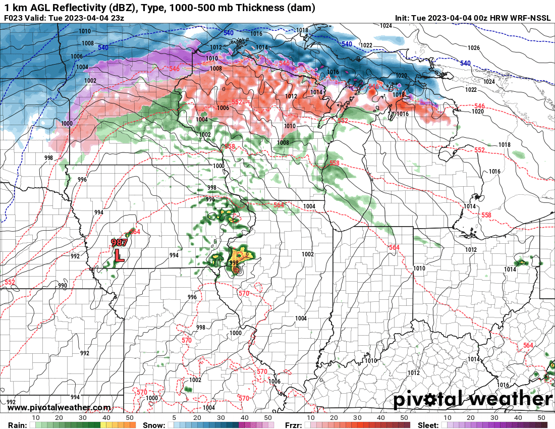
NSSL explicitly resolving a hook echo and intense mesocyclone.
More to your point of the contradiction:local met at the most watched station here in SWMO just said that after dark the tornado threat will be zero because all the storms will be behind the front…. Pretty direct contradiction of the SPC.
More to your point of the contradiction:
(Good thread, sounds like he/SPC remain quite bullish)
It's resolving a very strong mesocyclone, yes.Is that showing a supercell with its own small pressure gradient?
RRFS chose violence.


Day 1 Convective Outlook
NWS Storm Prediction Center Norman OK
0104 AM CDT Tue Apr 04 2023
Valid 041200Z - 051200Z
...THERE IS A MODERATE RISK OF SEVERE THUNDERSTORMS THERE IS A
MODERATE RISK OF SEVERE THUNDERSTORMS FROM EASTERN IOWA INTO
NORTHWEST ILLINOIS AND NORTHEAST MISSOURI...AND FROM SOUTHERN
MISSOURI SOUTHWESTWARD TOWARD THE ARKLATEX...
...SUMMARY...
A large area of severe potential will develop today into tonight,
from eastern portions of the Plains into the Missouri and mid/upper
Mississippi Valleys. Strong, potentially long track tornadoes are
possible, in addition to large hail and damaging winds. Both
afternoon and overnight potential is expected across various
regions, including the risk of dangerous nighttime tornadoes.
...Synopsis...
A deep upper trough will move from the Intermountain West/Rockies
toward the Great Plains today. Within the large-scale trough, an
upper cyclone will deepen as it moves northeastward toward the
Dakotas. An 80-100 kt midlevel jet will overspread the central
Plains during the afternoon/evening, while a secondary jet maximum
intensifies through the day from the southern Plains into parts of
the Midwest. At the surface, a broad cyclone will gradually
consolidate and deepen as it propagates from the central High Plains
toward western IA by early evening. A warm front will move northward
into central/northern IA and northern IL by late afternoon, and into
parts of WI/lower MI late tonight. A dryline will extend southward
across eastern portions of the central/southern Plains, with a cold
front expected to sweep through the Plains/Midwest this evening into
the overnight.
...Iowa into parts of the Great Lakes states...
Short-term guidance continues to vary greatly regarding the extent
of mixing across the warm sector over parts of the Midwest later
today. The typically overmixed RAP/HRRR drop surface dewpoints to
near 60F south of the warm front as temperatures warm to near 90F,
while the generally undermixed NAM maintains cooler temperatures and
upper 60s F dewpoints across the warm sector, and is slower to
advance the warm front northward. The current expectation is for the
magnitude of mixing to be somewhere between these two extremes, with
dewpoints remaining in the mid 60s in closer proximity to the warm
front, with somewhat stronger mixing possible farther south.
Considerable spread remains regarding convective evolution among
regional/global guidance and CAMs. However, two areas of possible
storm initiation this afternoon are evident. The first is near the
MO/IA/IL border region, where substantial warming/moistening beneath
steep midlevel lapse rates will result in rapid destabilization
near/south of the warm front. Any supercell that develops in this
region during the afternoon will pose a threat of very large to
giant hail. Very favorable low-level and deep-layer shear will
support a threat of strong tornadoes as well for as long as any
supercell traverses the warm sector along/south of the warm front.
The second area of potential initiation will be farther west across
west-central IA, closer to the surface low. Some uncertainty remains
regarding the moisture quality this far west, but moderate buoyancy
and very favorable wind profiles will support a threat of supercells
capable of all severe hazards, including the potential for a strong
tornado or two with any cell that can persist in the warm sector.
Additional convection may develop later tonight in association with
the cold front and move into the region, posing a threat of hail and
damaging gusts. A conditional tornado threat will also persist
overnight with any sustained supercells.
Finally, storms capable of hail will be possible north of the warm
front, where MUCAPE in excess of 1000 J/kg, steep midlevel lapse
rates, and sufficient deep-layer shear will support elevated
supercell potential, despite rather cold surface temperatures.
...Southern Plains into the Ozark Plateau...
A very favorable severe thunderstorm environment will also reside
across the southern Plains into the Ozark Plateau, beginning this
afternoon and persisting overnight east of the dryline/cold front.
Diurnal storm development along the dryline is expected to be
isolated at best, with large-scale ascent remaining weak for much of
the day. However, convection is expected to increase this evening
and especially overnight from northeast TX into AR and southern MO,
within a persistent low-level moist plume associated with a strong
low-level jet.
Moderate buoyancy and very favorable wind profiles will support
supercells, both with diurnal storms (if any develop) and nocturnal
convection. Some nocturnal storms may be somewhat elevated (at least
initially) and the mode may be a mix of discrete cells and clusters,
but weak MLCINH will not prohibit surface-based convection, and the
current expectation is for supercell potential to increase
overnight. Any nocturnal supercells will be capable of all severe
hazards, and the concern remains regarding the potential for
nocturnal strong tornadoes from near the ArkLaTex region into parts
of southern MO.
..Dean/Thornton.. 04/04/2023
Yeah that trend continues, look for spc put in a 10 percent hatched tornado threat in the enhanced for Kentucky close Tennessee border leastHRRR bringing the tornado threat further South for Wednesday.
I know where your chasing @CheeselandSkies hahahaHRRR is consistentlly firing a supercell in SE IA between 23 and 00Z, but soundings around it are still either super mixed or have a weird low-level inversion. The favorable tornado environment might exist only right on the warm front, where it's impossible to get an uncontaminated sounding. Low-level shear is monstrous in any case, though.
It is also showing some mid-morning convection in the area which you'd think might alleviate the mixing issue, but so far it doesn't seem to be according to the model.
The only time Michigan was put under a 10% tornado risk in the month of April was on April 11th, 2008. That wasn't hatched though. This would be the first 10% TOR hatch for Michigan going back to 2000 in the SPC archive in April.Can't remember the the last time Michigan had a 10% or greater risk for strong tornadoes. Looking like it's gonna be a interesting day