Kds86z
Member
We’ll see.. anything can happenYeah I’m not really seeing it either. The wind probs make sense but the Tor probs increase surprised me.
Follow along with the video below to see how to install our site as a web app on your home screen.
Note: This feature may not be available in some browsers.
We’ll see.. anything can happenYeah I’m not really seeing it either. The wind probs make sense but the Tor probs increase surprised me.
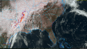
...Eastern MS and LA...AL...
A line of thunderstorms will be ongoing along the cold front early
on Sunday where MUCAPE will be on the order of 1000-1500 J/kg.
Severe potential will be mitigated somewhat due to the relatively
warm profiles aloft, however, veering winds with height and around
50 kt at 850 mb may support embedded supercells within the line,
with both wind and brief tornado potential. Depending on the degree
of outflow/convective contamination early in the day, a slightly
better corridor of tornado threat could materialize.


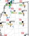
Waiting for tornado watch to pop. These may have better chance for isolated then up near the mdt..View attachment 39228
A bit concerned about these storms further south. They are relatively on their own and are headed in my direction.
View attachment 39220
Yurp, they indeed went with a Moderate. Unsure why but ok ig.
I guess Mother Nature didn’t take too kindly to Ja Morant this week
.jpeg")
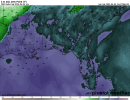
As you say that… tornado warning eastern ARdoubt this series of risks at your own peril.
that atmosphere over nw MS and sw TN is primed.

Thank you and blessings..It's pretty obvious why you saw the increase in tornado probability along with Moderate Upgrade. Dewpoints are upper 60s/low 70s. Very favorable for tornadoes. Only cloud cover is over Northwest MS while rest of North MS is seeing sunshine galore with temperatures already pushing 80.
This is my last post on here for a while. Peace.
Not gonna lie… 5/20 popped into my head yesterday but I kept my mouth shut..IIRC, that was also a notable failure mode for 5/20/2019.
It's hauling arse. 65 mph. A wall of straight line winds.PDS severe thunderstorm warning getting close to Memphis