CheeselandSkies
Member
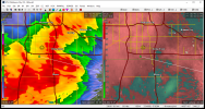
TORR with a storm embedded in the line west of Pawnee.
Follow along with the video below to see how to install our site as a web app on your home screen.
Note: This feature may not be available in some browsers.
So am I.Channel 9 met totally geeking out over the structure on air.
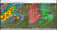
Not quite sure what's hampering these cells in the low levels but they are certainly struggling
Figures... Big Plains day turns into a nothingburger (last Friday an exception), while messy/marginal setups over the OH Valley/Dixie region produce significant or even historic episodes. (Mayfield a classic example)Yeah, there was a lot of talk about what an awesome environment there was gonna be for strong tornadoes today, but the storms certainly didn't behave like it (except the far eastern OK one well removed from where the main risk was thought to be).
*Now watch some bizarre EF2-3 QLCS spinup occur over Moore like in March of 2015.
This is how central Oklahoma events typically play out now. I have to go all the way back to 5/6/2015 to find a major OKC metro tornado day.
Yeah, there was a lot of talk about what an awesome environment there was gonna be for strong tornadoes today, but the storms certainly didn't behave like it (except the far eastern OK one well removed from where the main risk was thought to be).
*Now watch some bizarre EF2-3 QLCS spinup occur over Moore like in March of 2015.