
Navigation
Install the app
How to install the app on iOS
Follow along with the video below to see how to install our site as a web app on your home screen.
Note: This feature may not be available in some browsers.
More options
-
Welcome to TalkWeather! We see you lurking around TalkWeather! Take the extra step and join us today to view attachments, see less ads and maybe even join the discussion. CLICK TO JOIN TALKWEATHER
You are using an out of date browser. It may not display this or other websites correctly.
You should upgrade or use an alternative browser.
You should upgrade or use an alternative browser.
Severe WX April 19-20, 2020 Severe Weather Threat
- Thread starter Justin Hindman
- Start date
Kory
Member
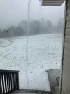
I don’t think snow would have water pouring off the roof like that.If I’m wrong I’m wrong but I feel like Spann got hoaxed with this one..,
Hail from Alexander City looking like snow from today...
skelly
Member
It does appear to be water gushing from the roof...
I’d have to know the source to be totally convinced. Crazy if legit though...
I’d have to know the source to be totally convinced. Crazy if legit though...
Bama Ravens
Member
What’s confusing to the non-weather nerds is that BMX’s graphic and SPC’s don’t quite matchup. For example, in the BMX graphic, where I am at north of Birmingham is in the “no threat” area. On the SPC graphic, though, I’m in the slight risk.Latest from NWS BMX... A little south:

Evan
Member
It does appear to be water gushing from the roof...
I’d have to know the source to be totally convinced. Crazy if legit though...
I think it is legit, too. I've run through some scenes like that while chasing. One time roads were almost impassable because hail was littering the road and congealed/melted into areas of sheer ice.
In the picture you posted, I can also make out some of the vapor trails that hail gives off when there is enough of it in one area and the ground is warm. Final thing is the rain pouring off the side of the roof which is most likely due to the gutter being clogged by hail.
I can see why you'd be suspicious of it. It's an odd looking picture and unfortunately so many people love to troll and get attention these days with fake images or reusing old ones.
Kory
Member
This has been a problem for a while now. But in theory the WFOs are more familiar with localized threats than the broad SPC outlook.What’s confusing to the non-weather nerds is that BMX’s graphic and SPC’s don’t quite matchup. For example, in the BMX graphic, where I am at north of Birmingham is in the “no threat” area. On the SPC graphic, though, I’m in the slight risk.
Bama Ravens
Member
Yeah, and I imagine the problem will always exist because of differences in opinion between SPC and the local NWS offices.This has been a problem for a while now. But in theory the WFOs are more familiar with localized threats than the broad SPC outlook.
JWard87
Member
Yeah, and I imagine the problem will always exist because of differences in opinion between SPC and the local NWS offices.
Only time you’ll probably see that it isn’t a problem is when it’s the WFO in Norman.
Tornado Warning in Northwestern LA.
823
WFUS54 KSHV 191819
TORSHV
LAC043-069-127-191900-
/O.NEW.KSHV.TO.W.0033.200419T1819Z-200419T1900Z/
BULLETIN - EAS ACTIVATION REQUESTED
Tornado Warning
National Weather Service Shreveport LA
119 PM CDT Sun Apr 19 2020
The National Weather Service in Shreveport has issued a
* Tornado Warning for...
West central Grant Parish in north central Louisiana...
East central Natchitoches Parish in northwestern Louisiana...
Southwestern Winn Parish in north central Louisiana...
* Until 200 PM CDT.
* At 118 PM CDT, a severe thunderstorm capable of producing a
tornado was located 9 miles southwest of Natchitoches, or
near Provencal, moving east at 45 mph.
HAZARD...Tornado.
SOURCE...Radar indicated rotation.
IMPACT...Flying debris will be dangerous to those caught without
shelter. Mobile homes will be damaged or destroyed.
Damage to roofs, windows, and vehicles will occur. Tree
damage is likely.
* This dangerous storm will be near...
Montgomery around 140 PM CDT.
Other locations impacted by this tornadic thunderstorm include
Melrose, Flora, Provencal, Natchez, Bermuda, Aloha and St. Maurice.
PRECAUTIONARY/PREPAREDNESS ACTIONS...
TAKE COVER NOW! Move to a basement or an interior room on the lowest
floor of a sturdy building. Avoid windows. If you are outdoors, in a
mobile home, or in a vehicle, move to the closest substantial shelter
and protect yourself from flying debris.
&&
LAT...LON 3158 9324 3170 9325 3180 9269 3155 9266
TIME...MOT...LOC 1818Z 265DEG 40KT 3164 9318
TORNADO...RADAR INDICATED
HAIL...<.75IN
$$
15
tennessee storm chaser
Member
- Messages
- 1,874
- Reaction score
- 4,283
- Location
- jackson tennessee
- Special Affiliations
- SKYWARN® Volunteer
latest meso just out, sounds like there could be a derecho type wind event developing
Yeah... but the hardwood trees in the background are showing no foliage. Looks very winteresque (sp) to me.I don’t think snow would have water pouring off the roof like that.
Yeah... but the hardwood trees in the background are showing no foliage. Looks very winteresque (sp) to me.
Well, there's plenty of trees where I'm at that currently don't show much if any foliage. I'm in favor of it being legit.
Last edited:
Kory
Member
Got a couple of rotating storms in North Central LA.
skelly
Member
There does seem to be some deciduous foliage missing that’s what made me have doubts. Other photos from the area show extensive ground coverage but not to the extent of that photo. Sometimes trees are dead but any live trees in Alexander City should be all out as of now. The gushing water is making me lean towards legit though.
Gawxnative
Member
MCS Getting together in LA/West MS now.. You can see motion of cells changing towards a SSW/NNE movement after the Warm Front Precip moves north. . Bit worrisome if they maintain that. while heading towards the rest of us (MS/AL/GA )
Jetstream
Member
So far 2.38 inches of rain. Temp 58.
BayouWeatherGeek
Member
Jetstream
Member
CC sig now on the tornadic storm in La.
Kory
Member
It has been pouring in Tuscaloosa. We might hit 4-5” once all is said and done.So far 2.38 inches of rain. Temp 58.
Wxhorse
Member
Radar from a few minutes ago. Edited to use thumbnail instead of full pic. Sorry! Still new to this
