• Welcome to TalkWeather!
    We see you lurking around TalkWeather! Take the extra step and join us today to view attachments, see less ads and maybe even join the discussion.
    CLICK TO JOIN TALKWEATHER
  • April 2024 Weather Video of the Month
    Post your nominations now!

Severe WX April 19-20, 2020 Severe Weather Threat

HazardousWx

Member
Messages
92
Reaction score
88
Location
Huntsville, AL
HAM Callsign
W4SSW
Special Affiliations
  1. SKYWARN® Volunteer
Very obvious where the warm front is located.
0851-4-19-20.png
Edit...I see you have answered this above....thanks!
 

weunice

Member
Messages
24
Reaction score
25
Location
Denham Springs, LA
Quick ob. SE LA here ... near Baton Rouge. FWIW compared to last weekend it is warmer, still very muggy and there are more gaps in the clouds over me streaming north at this point in the same day. I take a walk in the morning at the same time and am noticing the differences between the weeks.
 

warneagle

Member
Messages
3,870
Reaction score
3,520
Location
Arlington, VA
Special Affiliations
  1. SKYWARN® Volunteer
That storm moving over Fort Worth might be dropping some pretty good sized hail.
 
Messages
196
Reaction score
364
Location
Gardendale Alabama
Special Affiliations
  1. SKYWARN® Volunteer
  2. ARRL Member
I’m thinking it’s going to be a messy set up, will be interesting to see if any supercells can get going in Alabama and Mississippi. Looks embedded
 

Richardjacks

Member
Meteorologist
Messages
1,161
Reaction score
1,331
Location
Atop Red Mountain Birmingham, Al
Area Forecast Discussion
National Weather Service Birmingham AL
1038 AM CDT Sun Apr 19 2020

.UPDATE...
MESOSCALE UPDATE.

&&

.SHORT TERM...
/Updated at 1022 AM CDT Sun Apr 19 2020/

Multichannel water vapor imagery along with global model H500
fields agree in a well-defined trough over western Texas while a
shortwave trough was moving away from us positioned over Georgia.

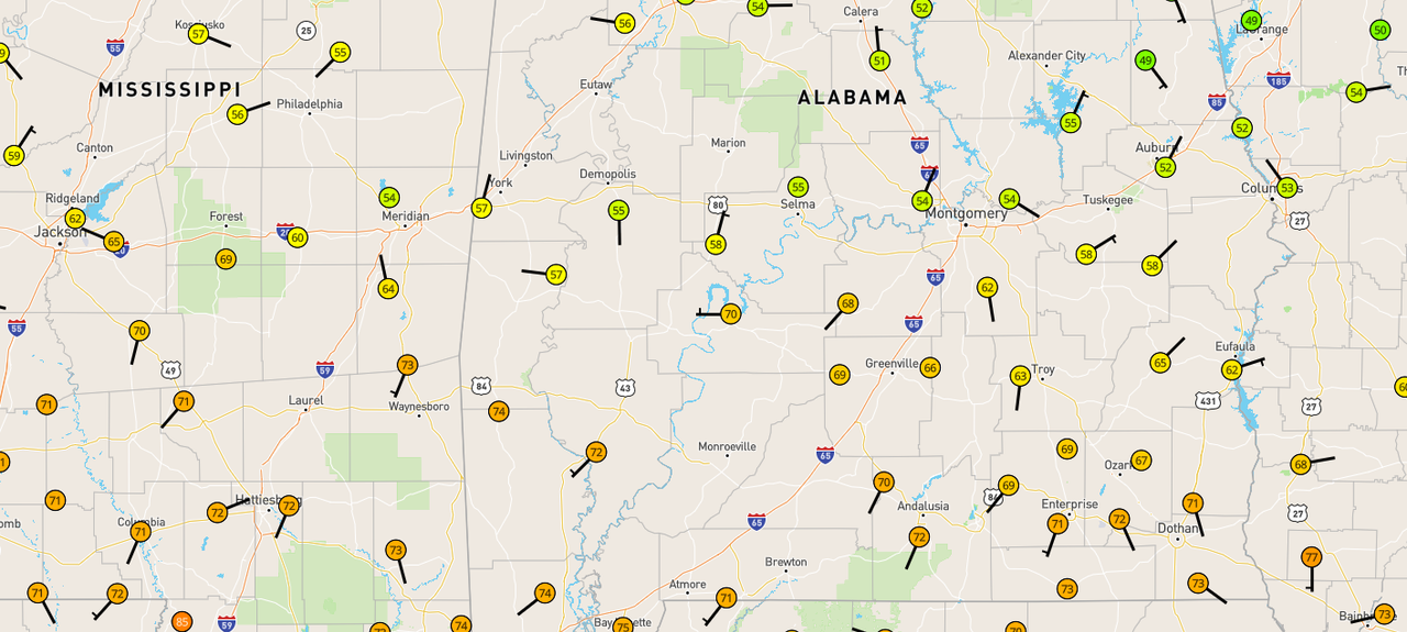
Hand surface analysis valid 14Z/9 am reveals the warm front
extending from south of Meridian, MS east to near Greenville and
extended further east to near Troy. The heavy morning convection
has produced outflow boundaries that have limited the warm front`s
northward advancement. The potential of the warm front overcoming
the expansive rain-cooled environment with locally higher surface
pressures is less likely compared to previous predictions. Expect
the warm front to remain south of the I-20 corridor with a more
likely position extending from south of Tuscaloosa to near
Sylacauga.

12Z National surface analysis shows low pressure now over far
southwest Oklahoma with a warm front extending to the southeast
through East Texas. A coastal/marine influenced warm front
extended from 50-100 miles inland of South Texas and this extended
east into our area.

The warm front is expected to remain south of the U.S. Highway 80
corridor through noon as the morning convective cold pool remains
dominant. This influence is expected to wane through early
afternoon with the warm front forecast to advance northward early
this afternoon.

While convection has become more isolated in nature, expect
isolated showers and some thunderstorms to continue to move across
our Southern and Central Counties. Large hail will remain the
primary threat though increasing wind fields and a destabilizing
boundary layer will permit a growing risk for damaging winds as we
head into the early afternoon hours.

Heavy rainfall with localized flooding remains a concern as
morning convection easily dropped over 2-4 inches. Additional
convection over these areas will aggravate saturated soils and
will runoff causing additional flooding. The Jackson, MS 12Z
Sounding contained a precipitable water value of 1.55 inches and
that airmass is likely in place now across much of our forecast
area.

The timing and locations for this afternoon`s severe weather
threat have been slightly adjusted with expectations of the warm
front nosing a bit further north into our western counties while
the residual mesohigh/cold pool is strong across West Georgia and
Eastern Alabama. Our primary concern remains across the southern
half of our area where the conditions remain favorable for intense
severe convection later this afternoon and into the evening
hours.

05
 

Kory

Member
Messages
4,928
Reaction score
2,119
Location
Tuscaloosa, Alabama
2000 J/KG MUCAPE feeding into that back building from North/Central MS into Central AL. Things could get ugly there flooding wise.
 

xJownage

Member
Messages
570
Reaction score
604
Location
Jacksonville, Florida
With this warm front being fairly stalled, it looks like the area in which we see the greatest risk for tornadoes is going to be in a moderate radar hole. Whatever chasers are out are going to play a very big role in warning lead time today.
 

South AL Wx

Member
Meteorologist
Messages
310
Reaction score
315
Location
Wetumpka, AL
Special Affiliations
  1. SKYWARN® Volunteer
New tornado watch out for portions of central and southern MS. Not a PDS, but the tornado probs are 90/70.
 

sak

Member
Messages
115
Reaction score
76
Location
Birmingham, AL
I just don’t understand the SPC. This is downtrending and those probs are pretty high

It really doesn't take much for it to "verify" though. One EF-2 tornado and a handful of spinups that are all on the ground for just a few minutes would warrant 90/70 if you are highly confident that is going to happen. The chances of a significant tornado in Birmingham has definitely downtrended but I don't really think the chances of a tornado in that watch area have really changed much.
 
Back
Top