• Welcome to TalkWeather!
    We see you lurking around TalkWeather! Take the extra step and join us today to view attachments, see less ads and maybe even join the discussion.
    CLICK TO JOIN TALKWEATHER

2025 Global Tropical Cyclone Season Discussion

As Peipah goes out to sea and finishes extratropical transition, we have an Invest 97W that is now a High chance invest just west of the northernmost Philippine islands.
View attachment 46426

WTPN21 PGTW 051430
MSGID/GENADMIN/JOINT TYPHOON WRNCEN PEARL HARBOR HI//
SUBJ/TROPICAL CYCLONE FORMATION ALERT (INVEST 97W) //
RMKS/
1. FORMATION OF A SIGNIFICANT TROPICAL CYCLONE IS POSSIBLE WITHIN
110 NM EITHER SIDE OF A LINE FROM 17.4N 119.1E TO 19.4N 116.3E
WITHIN THE NEXT 12 TO 24 HOURS. AVAILABLE DATA DOES NOT JUSTIFY
ISSUANCE OF NUMBERED TROPICAL CYCLONE WARNINGS AT THIS TIME.
WINDS IN THE AREA ARE ESTIMATED TO BE 15 TO 20 KNOTS. METSAT
IMAGERY AT 051200Z INDICATES THAT A CIRCULATION CENTER IS LOCATED
NEAR 17.6N 118.7E. THE SYSTEM IS MOVING WESTWARD AT 02 KNOTS.
2. REMARKS: THE AREA OF CONVECTION (INVEST 97W) PREVIOUSLY LOCATED NEAR
18.0N 118.9E IS NOW LOCATED NEAR 17.6N 118.7E, APPROXIMATELY 381.2 NM
SOUTHEAST OF HONG KONG. ANIMATED ENHANCED INFRARED IMAGERY (EIR) DEPICTS
A CONSOLIDATING CIRCULATION WITH A BAND OF FLARING CONVECTION JUST SOUTH
OF THE CENTER ASSISTING THE SYSTEM WITH A LINE OF CONVERGENCE DEEPENING
THE CONVECTION. A 051241Z METOP-B ASCAT IMAGE REVEALS 15-20 KT WINDS
FROM THE NORTHEAST AND THE SOUTHWEST BEGINNING TO WRAP CLOSER TO THE
CIRCULATION CENTER. ENVIRONMENTAL ANALYSIS FOR THE AREA INDICATES A
FAVORABLE ENVIRONMENT FOR DEVELOPMENT WITH LOW (10-15 KTS) VERTICAL WIND
SHEAR, WARM (30 C) SEA SURFACE TEMPERATURES, AND MODERATE EQUATORWARD
OUTFLOW ALOFT. ENSEMBLES ARE IN GOOD AGREEMENT THAT 97W WILL TRACK
NORTHWESTWARD TOWARDS MAINLAND CHINA WITH CONTINUED CONSOLIDATION OVER
THE NEXT 24 HOURS. MAXIMUM SUSTAINED SURFACE WINDS ARE ESTIMATED AT 15
TO 20 KNOTS.MINIMUM SEA LEVEL PRESSURE IS ESTIMATED TO BE NEAR 1005 MB.
THE POTENTIAL FOR THE DEVELOPMENT OF A SIGNIFICANT TROPICAL CYCLONE
WITHIN THE NEXT 24 HOURS IS HIGH.
3. THIS ALERT WILL BE REISSUED, UPGRADED TO WARNING OR CANCELLED BY
061430Z.
//
NNNN
Invest 97W is now known as Tropical Depression Lannie in the Philippines Area of Responsibility.


At 02:00 PHT on 6 September (18:00 UTC), the PAGASA gave the name Lannie to the system.<a href="https://en.wikipedia.org/wiki/2025_Pacific_typhoon_season#cite_note-215"><span>[</span>209<span>]</span></a>


- from the 2025 Pacific Typhoon Season article on Wikipedia.
 
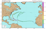
For Invest 91L, this would be my personal forecast as of now:


As of 8:00 pm EST September 5th, 2025


Central Tropical Atlantic (AL91):

Showers and thunderstorms have decreased in coverage in association with an area of low pressure located in the Tropical Atlantic. While strong dry air is inhibiting organization now, environmental conditions could become a little more favorable early next week as the disturbance moves westwards at 10 mph. Interests in the Leeward Islands should continue monitoring this system.


Formation Chance through 48 hours…low…10 percent

Formation Chance through 7 days…low…30 percent
 
This year has been anything but normal in the Northern Hemisphere.

This is an example (what is circled shouldn’t be possible with what the conditions should be like)
IMG_6627.jpeg
  • A hurricane north of Hawaii
  • A CPAC-named MH for the first time in the month of July
  • Another CPAC-named storm
  • Two open Pacific MHs (the first one is the July CPAC-named MH)
And this is all against what is supposed to be a negative Pacific Decadal Oscillation (-PDO)


The Western Pacific has also been being unusually quiet in major cyclones. We’re only had Danas (which wasn’t even operationally a major cyclone, the JTWC did an override a few days after the storm dissipated from 95 kts (110 mph) to 100 kts (115 mph) We’ve also had two 95 kt (110 mph) typhoons. Otherwise we have had a bunch of Category 1 equivalent typhoons and a bunch of TSs near or making landfall in Japan.
 
This year has been anything but normal in the Northern Hemisphere.

This is an example (what is circled shouldn’t be possible with what the conditions should be like)
View attachment 46428
  • A hurricane north of Hawaii
  • A CPAC-named MH for the first time in the month of July
  • Another CPAC-named storm
  • Two open Pacific MHs (the first one is the July CPAC-named MH)
And this is all against what is supposed to be a negative Pacific Decadal Oscillation (-PDO)


The Western Pacific has also been being unusually quiet in major cyclones. We’re only had Danas (which wasn’t even operationally a major cyclone, the JTWC did an override a few days after the storm dissipated from 95 kts (110 mph) to 100 kts (115 mph) We’ve also had two 95 kt (110 mph) typhoons. Otherwise we have had a bunch of Category 1 equivalent typhoons and a bunch of TSs near or making landfall in Japan.
The Atlantic has been oddly inactive aside from the random Category 5 that was Hurricane Erin. But we have the usual horseshoe anomalies that would signal a favorable basin. Erin put a dent in the subtropical warmth (which should have also began making it a bit more favorable too, because warm tropics and cool subtropics are correlated with active seasons)

We also have easterly trades (winds) blowing across the equator of the Eastern and Central Pacific, which is upwelling much cooler anomalies that could lead to a La Niña by later this upcoming fall.

But the Atlantic has struggled with developing cyclones due to mainly wave breaking, which is winds surging around the eastern side of the Bermuda-Azores High that brings down dry air and sometimes dust as well that chokes out tropical waves as the move west off the coast of Africa.
Just look at this. The Caribbean and Gulf have been dead this year so far, which is rare to see after passing through the entirety of August (a peak season month). All we have in the Gulf is Barry.
IMG_6628.png
 
This year has been anything but normal in the Northern Hemisphere.

This is an example (what is circled shouldn’t be possible with what the conditions should be like)
View attachment 46428
  • A hurricane north of Hawaii
  • A CPAC-named MH for the first time in the month of July
  • Another CPAC-named storm
  • Two open Pacific MHs (the first one is the July CPAC-named MH)
And this is all against what is supposed to be a negative Pacific Decadal Oscillation (-PDO)


The Western Pacific has also been being unusually quiet in major cyclones. We’re only had Danas (which wasn’t even operationally a major cyclone, the JTWC did an override a few days after the storm dissipated from 95 kts (110 mph) to 100 kts (115 mph) We’ve also had two 95 kt (110 mph) typhoons. Otherwise we have had a bunch of Category 1 equivalent typhoons and a bunch of TSs near or making landfall in Japan.
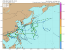
And here is the Western Pacific side of things to see what I mean:
IMG_6629.png
 
Yeah it’s so quiet @Atlantic.
For the entire Gulf U.S. coast to escape the entirety of June, July AND August without a TS or hurricane or even a major hurricane is very interesting to see compared to the past 10 years.

Usually before the peak season starts in August the gulf coast would have seen a weak, sloppy tropical storm or a strong tropical storm or two, and then the hurricanes would climatologically start to strike at the earliest in August.
 
This year has been anything but normal in the Northern Hemisphere.

This is an example (what is circled shouldn’t be possible with what the conditions should be like)
View attachment 46428
  • A hurricane north of Hawaii
  • A CPAC-named MH for the first time in the month of July
  • Another CPAC-named storm
  • Two open Pacific MHs (the first one is the July CPAC-named MH)
And this is all against what is supposed to be a negative Pacific Decadal Oscillation (-PDO)


The Western Pacific has also been being unusually quiet in major cyclones. We’re only had Danas (which wasn’t even operationally a major cyclone, the JTWC did an override a few days after the storm dissipated from 95 kts (110 mph) to 100 kts (115 mph) We’ve also had two 95 kt (110 mph) typhoons. Otherwise we have had a bunch of Category 1 equivalent typhoons and a bunch of TSs near or making landfall in Japan.
And to top this off, the spring season peak in the North Indian Ocean didn’t produce a TC.
 
And to top this off, the spring season peak in the North Indian Ocean didn’t produce a TC.
Which means the NIO doesn’t have a single true TC to date yet. There’s always the Oct-Nov-Dec Fall season for the basin though.
 
Invest 97W is now known as Tropical Depression Lannie in the Philippines Area of Responsibility.


At 02:00 PHT on 6 September (18:00 UTC), the PAGASA gave the name Lannie to the system.<a href="https://en.wikipedia.org/wiki/2025_Pacific_typhoon_season#cite_note-215"><span>[</span>209<span>]</span></a>


- from the 2025 Pacific Typhoon Season article on Wikipedia.
Invest 97W was upgraded to Tropical Depression 22W overnight, and JMA also upgraded it to Tropical Storm Tapah. JTWC now has it at 35 kts (40 mph). Tapah is expected to move west of Hong Kong and briefly reach typhoon status according to the JTWC.
 
Invest 97W was upgraded to Tropical Depression 22W overnight, and JMA also upgraded it to Tropical Storm Tapah. JTWC now has it at 35 kts (40 mph). Tapah is expected to move west of Hong Kong and briefly reach typhoon status according to the JTWC.
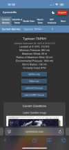
Tapah is now a typhoon by both JMA and the unofficial JTWC.
IMG_6926.png
 
Welcome to the Southern Hemisphere, where you get a high chance invest for the third consecutive month in a row despite it being winter down there. We had 01S in July and Awo in August.

Behold Invest 92S;
IMG_7028.gif
WTXS21 PGTW 082200
MSGID/GENADMIN/JOINT TYPHOON WRNCEN PEARL HARBOR HI//
SUBJ/TROPICAL CYCLONE FORMATION ALERT(INVEST 92S)//
RMKS/
1. FORMATION OF A SIGNIFICANT TROPICAL CYCLONE IS POSSIBLE WITHIN
155 NM EITHER SIDE OF A LINE FROM 8.8S 71.0E TO 9.1S 63.8E WITHIN
THE NEXT 12 TO 24 HOURS. AVAILABLE DATA DOES NOT JUSTIFY ISSUANCE
OF NUMBERED TROPICAL CYCLONE WARNINGS AT THIS TIME. WINDS IN THE
AREA ARE ESTIMATED TO BE 23 TO 28 KNOTS. METSAT IMAGERY AT
081800Z INDICATES THAT A CIRCULATION CENTER IS LOCATED NEAR 8.8S
71.0E. THE SYSTEM IS MOVING WEST-SOUTHWESTWARD AT 16 KNOTS.
2. REMARKS:THE AREA OF CONVECTION (INVEST 92S) PREVIOUSLY LOCATED AT
8.7S 71.3E IS NOW LOCATED NEAR 8.8S 71.0E, APPROXIMATELY 123 NM SW OF
DIEGO GARCIA. ANIMATED ENHANCED INFRARED SATELLITE IMAGERY DEPICTS DEEP
CONVECTION BUILDING OVER THE CENTER WITH CURVED DEEP CONVECTIVE BANDING.
A 081725Z ASCAT IMAGE SHOWS 25-30 KNOT WINDS WRAPPING AROUND A
CONSOLIDATING CIRCULATION. ENVIRONMENTAL ANALYSIS FOR THE AREA INDICATES
MODERATE FAVORABLE CONDITIONS FOR DEVELOPMENT WITH HIGH VERTICAL WIND
SHEAR (25-30 KTS), OFFSET BY WARM SEA SURFACE TEMPERATURES (28-29 C) AND
MODERATE POLEWARD OUTFLOW ALOFT. GLOBAL DETERMINISTIC MODELS ARE ALL IN
GOOD AGREEMENT THAT 92S WILL CONTINUE TO INTENSIFY OVER THE NEXT 48
HOURS ON A WESTWARD TRACK. GLOBAL ENSEMBLE MODELS ARE IN AGREEMENT AS
WELL THAT 92S WILL INTENSIFY OVER THE NEXT 48 HOURS WITH ECENS SHOWING
HIGHER INTENSITY SUPPORT.MAXIMUM SUSTAINED SURFACE WINDS ARE ESTIMATED
AT 23 TO 28 KNOTS.MINIMUM SEA LEVEL PRESSURE IS ESTIMATED TO BE NEAR
1001 MB. THE POTENTIAL FOR THE DEVELOPMENT OF A SIGNIFICANT TROPICAL
CYCLONE WITHIN THE NEXT 24 HOURS IS HIGH.
3. THIS ALERT WILL BE REISSUED, UPGRADED TO WARNING OR CANCELLED BY
092200Z.
//
NNNN
 
Welcome to the Southern Hemisphere, where you get a high chance invest for the third consecutive month in a row despite it being winter down there. We had 01S in July and Awo in August.

Behold Invest 92S;
View attachment 46497
WTXS21 PGTW 082200
MSGID/GENADMIN/JOINT TYPHOON WRNCEN PEARL HARBOR HI//
SUBJ/TROPICAL CYCLONE FORMATION ALERT(INVEST 92S)//
RMKS/
1. FORMATION OF A SIGNIFICANT TROPICAL CYCLONE IS POSSIBLE WITHIN
155 NM EITHER SIDE OF A LINE FROM 8.8S 71.0E TO 9.1S 63.8E WITHIN
THE NEXT 12 TO 24 HOURS. AVAILABLE DATA DOES NOT JUSTIFY ISSUANCE
OF NUMBERED TROPICAL CYCLONE WARNINGS AT THIS TIME. WINDS IN THE
AREA ARE ESTIMATED TO BE 23 TO 28 KNOTS. METSAT IMAGERY AT
081800Z INDICATES THAT A CIRCULATION CENTER IS LOCATED NEAR 8.8S
71.0E. THE SYSTEM IS MOVING WEST-SOUTHWESTWARD AT 16 KNOTS.
2. REMARKS:THE AREA OF CONVECTION (INVEST 92S) PREVIOUSLY LOCATED AT
8.7S 71.3E IS NOW LOCATED NEAR 8.8S 71.0E, APPROXIMATELY 123 NM SW OF
DIEGO GARCIA. ANIMATED ENHANCED INFRARED SATELLITE IMAGERY DEPICTS DEEP
CONVECTION BUILDING OVER THE CENTER WITH CURVED DEEP CONVECTIVE BANDING.
A 081725Z ASCAT IMAGE SHOWS 25-30 KNOT WINDS WRAPPING AROUND A
CONSOLIDATING CIRCULATION. ENVIRONMENTAL ANALYSIS FOR THE AREA INDICATES
MODERATE FAVORABLE CONDITIONS FOR DEVELOPMENT WITH HIGH VERTICAL WIND
SHEAR (25-30 KTS), OFFSET BY WARM SEA SURFACE TEMPERATURES (28-29 C) AND
MODERATE POLEWARD OUTFLOW ALOFT. GLOBAL DETERMINISTIC MODELS ARE ALL IN
GOOD AGREEMENT THAT 92S WILL CONTINUE TO INTENSIFY OVER THE NEXT 48
HOURS ON A WESTWARD TRACK. GLOBAL ENSEMBLE MODELS ARE IN AGREEMENT AS
WELL THAT 92S WILL INTENSIFY OVER THE NEXT 48 HOURS WITH ECENS SHOWING
HIGHER INTENSITY SUPPORT.MAXIMUM SUSTAINED SURFACE WINDS ARE ESTIMATED
AT 23 TO 28 KNOTS.MINIMUM SEA LEVEL PRESSURE IS ESTIMATED TO BE NEAR
1001 MB. THE POTENTIAL FOR THE DEVELOPMENT OF A SIGNIFICANT TROPICAL
CYCLONE WITHIN THE NEXT 24 HOURS IS HIGH.
3. THIS ALERT WILL BE REISSUED, UPGRADED TO WARNING OR CANCELLED BY
092200Z.
//
NNNN
And on top of that is this to the west, Invest 93S.
 

Attachments

  • IMG_7031.jpeg
    IMG_7031.jpeg
    1 MB · Views: 0
Welcome to the Southern Hemisphere, where you get a high chance invest for the third consecutive month in a row despite it being winter down there. We had 01S in July and Awo in August.

Behold Invest 92S;
View attachment 46497
WTXS21 PGTW 082200
MSGID/GENADMIN/JOINT TYPHOON WRNCEN PEARL HARBOR HI//
SUBJ/TROPICAL CYCLONE FORMATION ALERT(INVEST 92S)//
RMKS/
1. FORMATION OF A SIGNIFICANT TROPICAL CYCLONE IS POSSIBLE WITHIN
155 NM EITHER SIDE OF A LINE FROM 8.8S 71.0E TO 9.1S 63.8E WITHIN
THE NEXT 12 TO 24 HOURS. AVAILABLE DATA DOES NOT JUSTIFY ISSUANCE
OF NUMBERED TROPICAL CYCLONE WARNINGS AT THIS TIME. WINDS IN THE
AREA ARE ESTIMATED TO BE 23 TO 28 KNOTS. METSAT IMAGERY AT
081800Z INDICATES THAT A CIRCULATION CENTER IS LOCATED NEAR 8.8S
71.0E. THE SYSTEM IS MOVING WEST-SOUTHWESTWARD AT 16 KNOTS.
2. REMARKS:THE AREA OF CONVECTION (INVEST 92S) PREVIOUSLY LOCATED AT
8.7S 71.3E IS NOW LOCATED NEAR 8.8S 71.0E, APPROXIMATELY 123 NM SW OF
DIEGO GARCIA. ANIMATED ENHANCED INFRARED SATELLITE IMAGERY DEPICTS DEEP
CONVECTION BUILDING OVER THE CENTER WITH CURVED DEEP CONVECTIVE BANDING.
A 081725Z ASCAT IMAGE SHOWS 25-30 KNOT WINDS WRAPPING AROUND A
CONSOLIDATING CIRCULATION. ENVIRONMENTAL ANALYSIS FOR THE AREA INDICATES
MODERATE FAVORABLE CONDITIONS FOR DEVELOPMENT WITH HIGH VERTICAL WIND
SHEAR (25-30 KTS), OFFSET BY WARM SEA SURFACE TEMPERATURES (28-29 C) AND
MODERATE POLEWARD OUTFLOW ALOFT. GLOBAL DETERMINISTIC MODELS ARE ALL IN
GOOD AGREEMENT THAT 92S WILL CONTINUE TO INTENSIFY OVER THE NEXT 48
HOURS ON A WESTWARD TRACK. GLOBAL ENSEMBLE MODELS ARE IN AGREEMENT AS
WELL THAT 92S WILL INTENSIFY OVER THE NEXT 48 HOURS WITH ECENS SHOWING
HIGHER INTENSITY SUPPORT.MAXIMUM SUSTAINED SURFACE WINDS ARE ESTIMATED
AT 23 TO 28 KNOTS.MINIMUM SEA LEVEL PRESSURE IS ESTIMATED TO BE NEAR
1001 MB. THE POTENTIAL FOR THE DEVELOPMENT OF A SIGNIFICANT TROPICAL
CYCLONE WITHIN THE NEXT 24 HOURS IS HIGH.
3. THIS ALERT WILL BE REISSUED, UPGRADED TO WARNING OR CANCELLED BY
092200Z.
//
NNNN
This is now Tropical Cyclone 03S, and this is now the third preseason storm of the 2025-26 season. It's the first time in many years that we have had a storm in the SHEM in July, August and September. We are just missing October, and if we get a storm in October that would be the first time in many years that every off-season pre-season month has seen a storm.
 
This is now Tropical Cyclone 03S, and this is now the third preseason storm of the 2025-26 season. It's the first time in many years that we have had a storm in the SHEM in July, August and September. We are just missing October, and if we get a storm in October that would be the first time in many years that every off-season pre-season month has seen a storm.
93S is now a medium chance invest. This is giving the gut feeling that the upcoming 2025-26 Southern Hemisphere season is going to be an active one. We’ve already had three tropical cyclones in the SHEM and it’s not even November yet.
 
93S is now a medium chance invest. This is giving the gut feeling that the upcoming 2025-26 Southern Hemisphere season is going to be an active one. We’ve already had three tropical cyclones in the SHEM and it’s not even November yet.
The 1989-90 season produced two storms in July, with the second storm forming just about 24 hours after the first one dissipated, both were unnamed and in the SWIO.

The 2018-19 season saw two storms forming in September but there was a six day gap between the unnamed first one dissipating on the 19th after forming in the SWIO and the second one (named Liua) forming on the Pacific side of Australia on 25th.

To summarize: no SHEM pre-season going back to 1975 (the furthest back I consider reliable) in IBTrACS has seen simultaneously active storms before. If 93S does form it will as far as I am aware be the first time on record there were simultaneous storms active before November on record as well as for September and for the SWIO basin.
 
Back
Top