- Thread starter
- #941
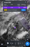
Invest 97W is now known as Tropical Depression Lannie in the Philippines Area of Responsibility.As Peipah goes out to sea and finishes extratropical transition, we have an Invest 97W that is now a High chance invest just west of the northernmost Philippine islands.
View attachment 46426
WTPN21 PGTW 051430
MSGID/GENADMIN/JOINT TYPHOON WRNCEN PEARL HARBOR HI//
SUBJ/TROPICAL CYCLONE FORMATION ALERT (INVEST 97W) //
RMKS/
1. FORMATION OF A SIGNIFICANT TROPICAL CYCLONE IS POSSIBLE WITHIN
110 NM EITHER SIDE OF A LINE FROM 17.4N 119.1E TO 19.4N 116.3E
WITHIN THE NEXT 12 TO 24 HOURS. AVAILABLE DATA DOES NOT JUSTIFY
ISSUANCE OF NUMBERED TROPICAL CYCLONE WARNINGS AT THIS TIME.
WINDS IN THE AREA ARE ESTIMATED TO BE 15 TO 20 KNOTS. METSAT
IMAGERY AT 051200Z INDICATES THAT A CIRCULATION CENTER IS LOCATED
NEAR 17.6N 118.7E. THE SYSTEM IS MOVING WESTWARD AT 02 KNOTS.
2. REMARKS: THE AREA OF CONVECTION (INVEST 97W) PREVIOUSLY LOCATED NEAR
18.0N 118.9E IS NOW LOCATED NEAR 17.6N 118.7E, APPROXIMATELY 381.2 NM
SOUTHEAST OF HONG KONG. ANIMATED ENHANCED INFRARED IMAGERY (EIR) DEPICTS
A CONSOLIDATING CIRCULATION WITH A BAND OF FLARING CONVECTION JUST SOUTH
OF THE CENTER ASSISTING THE SYSTEM WITH A LINE OF CONVERGENCE DEEPENING
THE CONVECTION. A 051241Z METOP-B ASCAT IMAGE REVEALS 15-20 KT WINDS
FROM THE NORTHEAST AND THE SOUTHWEST BEGINNING TO WRAP CLOSER TO THE
CIRCULATION CENTER. ENVIRONMENTAL ANALYSIS FOR THE AREA INDICATES A
FAVORABLE ENVIRONMENT FOR DEVELOPMENT WITH LOW (10-15 KTS) VERTICAL WIND
SHEAR, WARM (30 C) SEA SURFACE TEMPERATURES, AND MODERATE EQUATORWARD
OUTFLOW ALOFT. ENSEMBLES ARE IN GOOD AGREEMENT THAT 97W WILL TRACK
NORTHWESTWARD TOWARDS MAINLAND CHINA WITH CONTINUED CONSOLIDATION OVER
THE NEXT 24 HOURS. MAXIMUM SUSTAINED SURFACE WINDS ARE ESTIMATED AT 15
TO 20 KNOTS.MINIMUM SEA LEVEL PRESSURE IS ESTIMATED TO BE NEAR 1005 MB.
THE POTENTIAL FOR THE DEVELOPMENT OF A SIGNIFICANT TROPICAL CYCLONE
WITHIN THE NEXT 24 HOURS IS HIGH.
3. THIS ALERT WILL BE REISSUED, UPGRADED TO WARNING OR CANCELLED BY
061430Z.
//
NNNN
“
| At 02:00 PHT on 6 September (18:00 UTC), the PAGASA gave the name Lannie to the system.<a href="https://en.wikipedia.org/wiki/2025_Pacific_typhoon_season#cite_note-215"><span>[</span>209<span>]</span></a> |
- from the 2025 Pacific Typhoon Season article on Wikipedia.