- Thread starter
- #701
Follow along with the video below to see how to install our site as a web app on your home screen.
Note: This feature may not be available in some browsers.
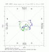
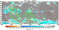
Literally everything is spinning in the Western Pacific right now due to a monsoon event blowing up!
View attachment 45329
From left to right: Invest 98W, Invest 90W, Tropical Depression 10W (Dante) (Formerly Invest 97W, now TD 10W) and on the far right, Invest 99W.
Some of them (like 98W) will be. Some of them won’t according to the models.hopefully just some fish storms
oh i see gotcha good to knowInvest 98W could become an OTS powerful typhoon and the JTWC has it at medium chance right now. This system is expected to stay out to sea other then affecting the Mariana Islands early on.
Invest 99W is at medium chance too and it could stall around the top end of the Philippines before possibly getting absorbed into the monsoonal flow.
Invest 90W is new and it hasn’t been noticed on the JTWC home page map yet.
Former Invest 97W became Tropical Depression 10W and it received the Philippine name Dante. 10W is expected to strengthen into a short-lived TS before getting absorbed into the monsoonal flow.
Wipha has moved inland over northern Vietnam and it is dissipating, however its remnants could cross over into the Bay of Bengal and possibly power a monsoon low expected to form here soon.
Here is the most recent JTWC homepage tropical weather map:
View attachment 45330
gotchaThe NHC and the CPHC have noted an AoI that is expected to develop into a disturbance in a few days. The reason the Central Pacific Hurricane Center has in correlation with the National Hurricane Center noted this disturbance is because it is centered from roughly 145*W to 135*W, and the Central Pacific begins at 140*W and ends at the International Dateline (180*W)
The wording is the same from both sides, but I’ll show it from both:
National Hurricane Center side:
View attachment 45331
Central Pacific Hurricane Center side:
View attachment 45332
oh welp at least some of them will be fish storms but it does suck how some of them wont be fish storms unfortunatelySome of them (like 98W) will be. Some of them won’t according to the models.
Thanks @AtlanticInvest 98W could become an OTS powerful typhoon and the JTWC has it at medium chance right now. This system is expected to stay out to sea other then affecting the Mariana Islands early on.
Invest 99W is at medium chance too and it could stall around the top end of the Philippines before possibly getting absorbed into the monsoonal flow.
Invest 90W is new and it hasn’t been noticed on the JTWC home page map yet.
Former Invest 97W became Tropical Depression 10W and it received the Philippine name Dante. 10W is expected to strengthen into a short-lived TS before getting absorbed into the monsoonal flow.
Wipha has moved inland over northern Vietnam and it is dissipating, however its remnants could cross over into the Bay of Bengal and possibly power a monsoon low expected to form here soon.
Here is the most recent JTWC homepage tropical weather map:
View attachment 45330
Dang I hope no rain for TexasLet’s do it again! Round 2 of ex-93L!
View attachment 45337
WTPQ51 RJTD 230000 RSMC TROPICAL CYCLONE ADVISORY NAME TS 2507 FRANCISCO (2507) UPGRADED FROM TD ANALYSIS PSTN 230000UTC 20.4N 130.4E FAIR MOVE NW 11KT PRES 996HPA MXWD 035KT GUST 050KT 30KT 350NM NORTHEAST 150NM SOUTHWEST FORECAST 12HF 231200UTC 22.0N 128.5E 40NM 70% MOVE NW 12KT PRES 996HPA MXWD 035KT GUST 050KT 24HF 240000UTC 23.6N 126.8E 57NM 70% MOVE NW 11KT PRES 994HPA MXWD 040KT GUST 060KT 48HF 250000UTC 25.9N 123.7E 115NM 70% MOVE NW 09KT PRES 990HPA MXWD 040KT GUST 060KT 72HF 260000UTC 27.6N 121.2E 160NM 70% TROPICAL DEPRESSION = |
The official warning on Tropical Depression 11W;Tropical Depression 11W first warning cone and forecast intensities:
View attachment 45342
View attachment 45343
Tropical Depression 11W has been upgraded by PAGASA to tropical depression by them as well, and it is now currently known as Tropical Depression Emong there.Tropical Depression 11W first warning cone and forecast intensities:
View attachment 45342
View attachment 45343
WTPQ50 RJTD 231200 RSMC TROPICAL CYCLONE ADVISORY NAME TS 2508 CO-MAY (2508) UPGRADED FROM TD ANALYSIS PSTN 231200UTC 17.7N 118.8E FAIR MOVE W 08KT PRES 994HPA MXWD 035KT GUST 050KT 30KT 90NM FORECAST 12HF 240000UTC 16.9N 118.6E 40NM 70% MOVE S SLOWLY PRES 990HPA MXWD 040KT GUST 060KT 24HF 241200UTC 16.4N 119.1E 57NM 70% MOVE SE SLOWLY PRES 980HPA MXWD 050KT GUST 070KT 48HF 251200UTC 20.3N 123.2E 100NM 70% MOVE NE 14KT PRES 994HPA MXWD 035KT GUST 050KT 72HF 261200UTC 25.4N 129.6E 160NM 70% TROPICAL DEPRESSION = |