KevinH
Member
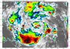
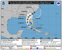
Not sure what the criteria is for starting a thread about hurricanes. Severe threats I think we got covered, but hurricanes… no idea.Not sure we want to start a thread or wait, but good article from Bryan Nordcross on 97L He reference Hurricane Elena as a possible sitsituation with the steering currents.

Bryan Norcross: Latest computer forecasts indicate tropical system could stall, impact Florida for days
Welcome to August. The various computer forecast models have coalesced around the idea that the tropical disturbance we've been following will track into the Gulf of Mexico.www.foxweather.com
Definitely need to be mindful in the coming months.